1816 Thomson Map of Grenada, Curacao, Trinidad, and Tobago

SouthernAntilles-thomson-1816
$250.00
West India Islands. - Main View
Processing...

1816 Thomson Map of Grenada, Curacao, Trinidad, and Tobago

SouthernAntilles-thomson-1816

Bargaining Chips of Colonial Competition.
$250.00

Title


West India Islands.
  1816 (dated)     20.5 x 23.75 in (52.07 x 60.325 cm)

Description


A map of the Caribbean islands of Grenada, Curacao, Trinidad, and Tobago in the Lesser Antilles, prepared by John Thomson and engraved by Samuel Neele for Thomson's New General Atlas.
A Closer Look
Grenada, Curacao, Trinidad, and Tobago are displayed with varying scales with internal administrative divisions, roads, religious missions, churches, and other individual buildings illustrated. Mountains, waterways, and other geographical features are noted, with terrain on Trinidad and Curacao indicated. The map of Curacao also includes an inset of Fort Amsterdam, part of the capital city of Willemstad, including anchorages. Remarks on sources of fresh water, local history, and helpful hints to travelers also appear throughout.
Historical Context
These islands changed hands regularly during the 16th-19th centuries as European powers traded them as part of global colonial empires. Trinidad, Tobago, and Grenada progressed through Spanish, then French, and finally British rule, or at least preponderant influence, before independence in the post-World War II period. Curacao is the outlier, having been Spanish and then Dutch, thanks to the Eighty Years’ War (1568 - 1648), and remaining part of the Kingdom of the Netherlands, albeit with significant autonomy.
Publication History and Census
This map was prepared by John Thomson and engraved by Samuel John Neele for inclusion in Thomson's New General Atlas, which went through multiple printings in Edinburgh, London, and Dublin between 1815 and 1817. Examples of the map display different pagination (or none at all) and other minor details depending on the printing, with the plate number here (No. 68) seemingly added separately from the main plate.

CartographerS


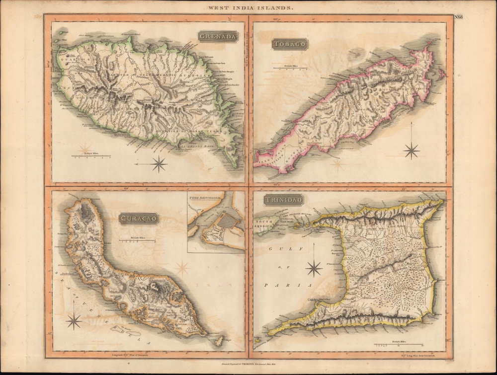
John Thomson (1777 - c. 1841) was a Scottish cartographer, publisher, and bookbinder active in Edinburgh during the early part of the 19th century. Thomson apprenticed under Edinburgh bookbinder Robert Alison. After his apprenticeship he briefly went into business with Abraham Thomson. Later the two parted ways, John Thomson segueing into maps and Abraham Thomson taking over the bookbinding portion of the business. Thomson is generally one of the leading publishers in the Edinburgh school of cartography which flourished from roughly 1800 to 1830. Thomson and his contemporaries (Pinkerton and Cary) redefined European cartography by abandoning typical 18th century decorative elements such as elaborate title cartouches and fantastic beasts in favor of detail and accuracy. Thomson's principle works include Thomson's New General Atlas, published from 1814 to 1821, the New Classical and Historical Atlas of 1829, and his 1830 Atlas of Scotland. The Atlas of Scotland, a work of groundbreaking detail and dedication would eventually bankrupt the Thomson firm in 1830, at which time their plates were sequestered by the court. The firm partially recovered in the subsequent year allowing Thomson to reclaim his printing plates in 1831, but filed again for bankruptcy in 1835, at which time most of his printing plates were sold to A. K. Johnston and Company. There is some suggestion that he continued to work as a bookbinder until 1841. Today, Thomson maps are becoming increasingly rare as they are highly admired for their impressive size, vivid hand coloration, and superb detail. More by this mapmaker...


Samuel John Neele (July 29, 1758 - May 13, 1824) was a prolific British map engraver active in the late 18th and early 19th centuries. Neele apprenticed as a printer and engraver with Harry Ashby from about 1781 to 1782 before establishing himself independently in 1785 at 352 Strand, London. The combination of business acumen and technical skill made Neele extremely successful with literally hundreds of maps to his credit. His vast corpus was composed of notable maps by most major English publishers of the period including, Haywood, Faden, Wallis, Stockdale, Arrowsmith, Thomson, Pinkerton, and Greenwood, among others. Neele's sons, James and Josiah Neele, also engravers, took over their fathers business around 1818, both becoming notable in their own right. Learn More...

Source


Thomson, J., A New General Atlas, (Edinburgh) 1817.     Thomson's New General Atlas was first published in 1817 and continued to be published until about 1821. This is the first of Thomson's major cartographic works and the atlas for which is most celebrated. The New General Atlas follows in the Edinburgh School, which eschews excessive decoration in favor of a more minimalistic fact-based cartographic vision, as established by John Pinkerton, Laurie and Whittle, John Cary, and others in the previous decades. The maps are notable for their massive scale, heavy stock, elegant color work, and easy-to-read typefaces. Although the atlas stopped being published after 1821, Thomson continued to offer 'supplementary' maps that could be tipped into the atlas as late as 1830, when he declared bankruptcy. The maps in the Thomson Atlas were engraved by Thomas Clerk, William Dassauville, Nathaniel Rogers Hewitt, James Kirkwood, Robert Kirkwood, John Menzies, George Menzies, Edward Mitchell, John Moffatt, Samuel John Neele, Robert Scott, and James Wyld.

Condition


Very good. Light offsetting.

References


Rumsey 1007.074.