This item has been sold, but you can get on the Waitlist to be notified if another example becomes available, or purchase a digital scan.
1638 Jansson Map of Norway
Stavangriensis-jansson-1638$475.00

Title
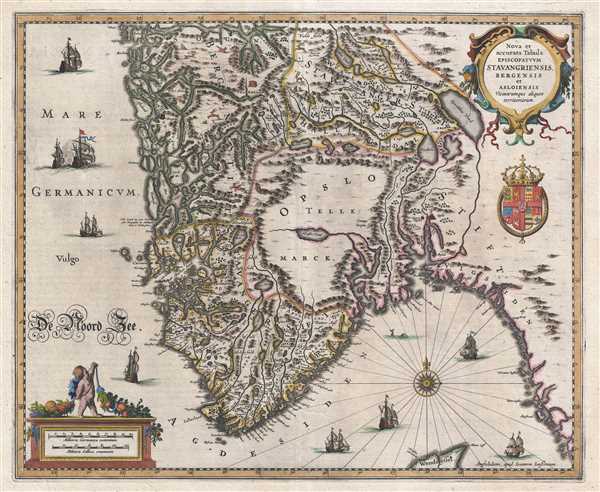
Nova et accurata Tabula Episcopatvvm Stavangriensis, Bergensis et Asloiensis.
1638 (undated) 16 x 19.5 in (40.64 x 49.53 cm) 1 : 1000000
1638 (undated) 16 x 19.5 in (40.64 x 49.53 cm) 1 : 1000000
Description
This is a 1638 Jan Jansson or Johannes Jansonnius map of Norway. The map depicts Norway from the North Sea to Sweden and from the region around Bergen to the North Sea. Both Bergen and Oslo are labeled and marked using small symbols resembling cities. The intricately entwined waterways of the Norwegian coast are illustrated, along with numerous rivers. Mountain ranges and forests are presented in profile. Several different animals are included near the top of the map, including stags, foxes, wolves, and a bear. Several sailing ships are depicted in the ocean, along with a sea monster. A title cartouche is situated in the upper right corner, along with what appears to be a royal crest. An allegorical cartouche, in the lower left corner, bears the scale.
This map was produced by Jan Jansson in 1638.
This map was produced by Jan Jansson in 1638.
Cartographer
Jan Jansson or Johannes Janssonius (1588 - 1664) was born in Arnhem, Holland. He was the son of a printer and bookseller and in 1612 married into the cartographically prominent Hondius family. Following his marriage he moved to Amsterdam where he worked as a book publisher. It was not until 1616 that Jansson produced his first maps, most of which were heavily influenced by Blaeu. In the mid 1630s Jansson partnered with his brother-in-law, Henricus Hondius, to produce his important work, the eleven volume Atlas Major. About this time, Jansson's name also begins to appear on Hondius reissues of notable Mercator/Hondius atlases. Jansson's last major work was his issue of the 1646 full edition of Jansson's English Country Maps. Following Jansson's death in 1664 the company was taken over by Jansson's brother-in-law Johannes Waesberger. Waesberger adopted the name of Jansonius and published a new Atlas Contractus in two volumes with Jansson's other son-in-law Elizée Weyerstraet with the imprint 'Joannis Janssonii haeredes' in 1666. These maps also refer to the firm of Janssonius-Waesbergius. The name of Moses Pitt, an English map publisher, was added to the Janssonius-Waesbergius imprint for maps printed in England for use in Pitt's English Atlas. More by this mapmaker...
Condition
Very good. Closed margin tears professionally repaired on verso. Blank on verso.
References
OCLC 159836217.