Digital Image: 1882 Williamson Map of Central Florida Canal Surveys
SteamboatComm-williamson-1882_d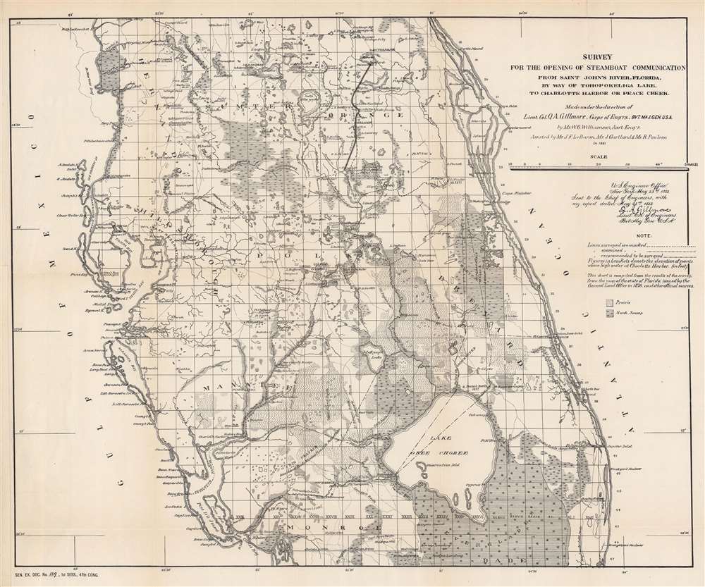

Title
Survey for the Opening of Steamboat Communication from Saint John's River, Florida, by Way of Tohopokeliga Lake, to Charlotte Harbor or Peace Creek.
1882 (dated) 18 x 21.75 in (45.72 x 55.245 cm) 1 : 704000
1882 (dated) 18 x 21.75 in (45.72 x 55.245 cm) 1 : 704000
Description
FOR THE ORIGINAL ANTIQUE MAP, WITH HISTORICAL ANALYSIS, CLICK HERE.
Digital Map Information
Geographicus maintains an archive of high-resolution rare map scans. We scan our maps at 300 DPI or higher, with newer images being 600 DPI, (either TIFF or JPEG, depending on when the scan was done) which is most cases in suitable for enlargement and printing.
Delivery
Once you purchase our digital scan service, you will receive a download link via email - usually within seconds. Digital orders are delivered as ZIP files, an industry standard file compression protocol that any computer should be able to unpack. Some of our files are very large, and can take some time to download. Most files are saved into your computer's 'Downloads' folder. All delivery is electronic. No physical product is shipped.
Credit and Scope of Use
You can use your digial image any way you want! Our digital images are unrestricted by copyright and can be used, modified, and published freely. The textual description that accompanies the original antique map is not included in the sale of digital images and remains protected by copyright. That said, we put significant care and effort into scanning and editing these maps, and we’d appreciate a credit when possible. Should you wish to credit us, please use the following credit line:
Courtesy of Geographicus Rare Antique Maps (https://www.geographicus.com).
How Large Can I Print?
In general, at 300 DPI, you should at least be able to double the size of the actual image, more so with our 600 DPI images. So, if the original was 10 x 12 inches, you can print at 20 x 24 inches, without quality loss. If your display requirements can accommodate some loss in image quality, you can make it even larger. That being said, no quality of scan will allow you to blow up at 10 x 12 inch map to wall size without significant quality loss. For more information, it is best consult a printer or reprographics specialist.
Refunds
If the high resolution image you ordered is unavailable, we will fully refund your purchase. Otherwise, digital images scans are a service, not a tangible product, and cannot be returned or refunded once the download link is used.
Cartographer
Quincy Adams Gillmore (February 28, 1825 - April 7, 1888) was an American army officer, engineer, and Union general during the American Civil War. Born at Black River, Ohio, Gillmore graduated at the top of his class from the United States Military Academy at West Point in 1849. Upon graduation, Gillmore was commissioned as a second lieutenant in the Army Corps of Engineers. During these early years he helped plan the fortifications of Hampton Roads, Virginia. He returned to West Point in 1852 to teach practical military engineering. He was transferred to New York City in 1856 and became the army's chief engineer in the region. When the American Civil War started, Gillmore ended up on General Thomas W. Sherman's staff, and accompanied him on the Port Royal expedition in 1861. In 1862, Gillmore (who had been promoted to brigadier general) was in command of the siege of Fort Pulaski. During this siege and ensuing battle, Gillmore became the first military officer to effectively use the new naval rifled artillery to destroy and enemy stone fortification. His actions at Fort Pulaski earned Gillmore national attention. Gillmore served in various capacities throughout the rest of the American Civil War, including as commander of the Department of the South from June 12, 1863, until May 1, 1864. Then, as commander of the X Corps, Gillmore and his corps were transferred to the Army of the James in Virginia, where they participated in the Bermuda Hundred campaign. Gillmore feuded with his commander, Benjamin Butler, over the Union defeat, which led him to be transferred to Washington, D.C. While in D.C., Gillmore commanded the defense of the city against 10,000 Confederate soldiers under the command of Jubal A. Early. Gillmore resigned from the Army on December 5, 1865. He returned to New York, where he became a prominent civil engineer. He authored several books. He also played a role in rebuilding the coastal fortifications along the Atlantic coast destroyed during the war. More by this mapmaker...
References
University of South Florida U15-0071. OCLC 39552559.