1852 Vuillemin Map of Switzerland
Switzerland-vuillemin-1852$150.00

Title
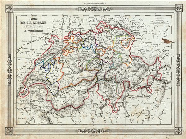
Carte de la Suisse.
1858 (undated) 10 x 13 in (25.4 x 33.02 cm)
1858 (undated) 10 x 13 in (25.4 x 33.02 cm)
Description
An uncommon and extremely attractive 1852 map of Switzerland. The map covers the entire country and shows the division by Cantons from Vaud to Grisons. Also shows parts of adjacent France, Germany, and Italy. Throughout, the map identifies various cities, towns, rivers and assortment of additional topographical details. Switzerland at this time was undergoing a rapid social and economic change known as the Regeneration Movement. Following the French July Revolution in 1830 the Swiss began assemble and call for fair representation and new cantonal constitutions. Many of the cantons subsequently established representative governments and instituted freedom of the press and trade. The map features a beautiful frame style border. Prepared by A. Vuillemin for publication as plate no. 15 in Maison Basset's 1852 edition of Atlas Illustre Destine a l'enseignement de la Geographie elementaire.
CartographerS
Alexandre Aimé Vuillemin (1812 - 1880) was an engraver, publisher, and editor based in Paris, France in the middle of the 19th century. Despite a prolific publishing career, much of Vuillemin's life is shrouded in mystery. In 1852, he married Josephine Caroline Goret and they had at least one child, Ernestine Adèle Vuillemin, later in the same year. What is known is that his studied under the prominent French Auguste Henri Dufour (1798 - 1865). Vuillemin's most important work his detailed, highly decorative large format Atlas Illustre de Geographie Commerciale et Industrielle. More by this mapmaker...
Jean Denis Barbie du Bocage (1760 - 1825) and his son Jean-Guillaume Barbie du Bocage (1795 - 1848) were French cartographers and cosmographers active in Paris during late 18th and early 19th centuries. The elder Barbie du Bocage, Jean Denis, was trained as a cartographer and engraver in the workshops of mapmaking legend J. B. B. d'Anville. At some point Jean Denis held the post of Royal Librarian of France and it was through is associations with d'Anville that the d'Anville collection of nearly 9000 maps was acquired by French Ministry of Foreign Affairs. The younger Barbie du Bocage, Jean-Guillaume, acquired a position shortly afterwards at the Ministry of Foreign Affairs and, in time, became its head, with the title of Geographe du Ministere des Affaires Etrangeres. Learn More...
Source
Barbie du Bocage, J. D., Atlas Illustre Destine a l'Enseignement de la Geographie Elementaire, (Paris: Maison Basset) 1852.
Condition
Very good. Blank on verso. Minor foxing throughout. Small discoloration near the right margin over Bavaria.