This item has been sold, but you can get on the Waitlist to be notified if another example becomes available, or purchase a digital scan.
1726 Valentijn Map of Taiwan or Formosa
TaiwanFormosa-valentijn-1726$2,250.00

Title
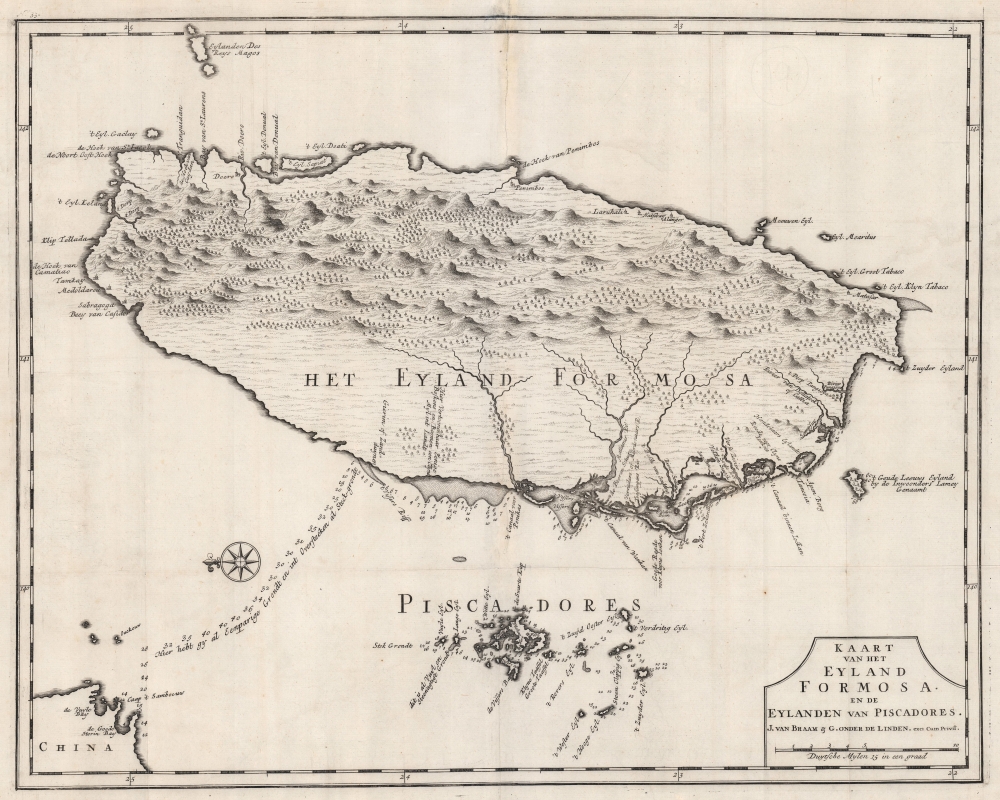
Kaart van het Eyland Formosa en de Eylanden van Piscadores.
1726 (undated) 18 x 22.5 in (45.72 x 57.15 cm) 1 : 850000
1726 (undated) 18 x 22.5 in (45.72 x 57.15 cm) 1 : 850000
Description
Printed in 1726 by Francois Valentijn, this is the earliest and most desirable printed map of Taiwan or Formosa. It is considered the first specific printed map of Formosa. Oriented to the east, with north at the left, Valentijn's map covers the entire island was well as the nearby Pescadores, now known as the Penghu Islands, and the nautical route to the Chinese coastal province of Fujian. Soundings appear around the Pescadores, along the west coast of Taiwan, and extend to the Chinese coast.
The history and hopes of Dutch Formosa can be read into this map. The trade routes to China and the inclusion of the Pescadores are indicative of the VOC's intent and long-term strategy. As noted by the Taiwan historian Keating, 'Since Taiwan's major ports were dotted along its western coastline, many believed that whoever controlled the Pescadores controlled Taiwan.' The soundings suggest both a firm occupation of the Pescadores and hint at a well-established trade route with Fujian Province. The VOC, however, was never able to secure a reliable commercial treaty with China and this map remains one of the most significant lasting legacies of the VOC in Formosa.
The Source Map
Cartographically Valentijn based this map on the 1640 manuscript (hand drawn) map of Formosa drawn by Johannes Vingboones. Vingboons based his famous map upon information gleaned during the brief Dutch occupation of Formosa between 1624 and 1662. At the time, and today, Vingboons' manuscript is the best early map of Taiwan or Formosa to survive. No doubt, when Valentijn prepared to publish his Oud en Nieuw Oost-Indien this was also the case. While Valentijn's map closely follows the more decorative work of Vingboons, it is not a slavish copy. Valentijn added significant new information to the north and northeastern parts of the island - doubtless extracted from additional information derived from now unknown charts. Moreover, some of the soundings have been revised or updated.Dutch Formosa
At the time the western part of Taiwan was partially colonized by Chinese immigrants, while the eastern lands were dominated by ferocious headhunting tribes with an history of inhospitality. The Dutch East India Company (VOC) (which established itself in western Formosa in 1624) was intent on pacifying the aggressive Formosan aborigines and ultimately establishing a trading center capable of rivaling Macao and thus challenging Portuguese dominance of the China trade. The Dutch were repeatedly rebuffed by the Chinese and ultimately driven out of Formosa entirely in 1668 by a Chinese backed aborigine resistance.The history and hopes of Dutch Formosa can be read into this map. The trade routes to China and the inclusion of the Pescadores are indicative of the VOC's intent and long-term strategy. As noted by the Taiwan historian Keating, 'Since Taiwan's major ports were dotted along its western coastline, many believed that whoever controlled the Pescadores controlled Taiwan.' The soundings suggest both a firm occupation of the Pescadores and hint at a well-established trade route with Fujian Province. The VOC, however, was never able to secure a reliable commercial treaty with China and this map remains one of the most significant lasting legacies of the VOC in Formosa.
A Formerly Secret Map
Francois Valentijn (1666 - 1727), a missionary, printer, and author was among the first to publish on the history and management of the VOC in the East Indies. Cartographic knowledge of the Dutch East Indies was tightly controlled by the VOC throughout the 17th century. Valuable cartographic data was typically shared among VOC pilots in manuscript form and rarely ever submitted to printing. Valentijn spent sixteen years in the East Indies as a VOC minister and, as such, doubtless had access to secret charts, such as the Vingboons Atlas. Despite the strict VOC injunction on publishing its valuable maps, Valentijn successfully published his work in 1726. In the same year Johannes van Keulen II was commissioned as official VOC hydrographer and published his own 'secret atlas' of VOC maps. The fact that both were published in 1726 suggests that the era of VOC dominance in the East Indies had nearly come to an end.Publication History and Census
This map was issued in Amsterdam as plate no. 33 in Francois Valentijn's 1726 Oud en nieuw Oost-Indien . It was published by Joannes van Braam and Gerard onder de Linden, whose names appear on the imprint. Today this important map is exceedingly rare. We note only two examples cataloged in OCLC which are part of the collections at the Library of Congress and the British Library.Cartographer
Francois Valentijn (April 17, 1666 - August 6, 1727) was a Dutch minister, naturalist, colonial administrator, and historian active in Holland and the East Indies, in the late 17th and early 18th centuries. Valentijn was born in Dordrecht, Holland and studied at the Universities and Leiden and Utrecht before, in 1685, taking a position with the Dutch East India Company (VOC). He remained in the East Indies for about 10 years before returning to Dordrecht. Unable to adjust to life in Europe, he returned to the East Indies in 1705 where he remained for another 9 years. After 19 total years in the Orient working for the VOC, Valentijn once again returned to Holland where he composed his eight volume five part masterwork Oud en Nieuw Oost-Indien. The scope and detail of this work, including over 1000 engraved images and numerous maps was unprecedented with regards to Asia. The work contained some of the finest and most detailed large scale maps of the East Indies ever published. The most important of these focus on Taiwan and Malaya. Valentijn most likely drew on secret VOC manuscript maps and documents, a fact that makes it exceptionally surprising that his works were actually published. Valentijn academic scholarship, in sharp contrast to his cartographic work, is often highly criticized as being self-aggrandizing and, more often than not, plagiarized. More by this mapmaker...
Source
Valentijn, F., Oud en Nieuw Oost-Indien, (Dordrecht: J. van Braam) 1726.
Condition
Very good. Minor verso repair top centerfold. Wear along original fold lines. Platemark visible.
References
OCLC: 51828226. Library of Congress, Map Division, G7910 1726 .B7 1997. Keating, Jerome F., The Mapping of Taiwan Desired Economies, Coveted Geographies, pages 72-73.