This item has been sold, but you can get on the Waitlist to be notified if another example becomes available, or purchase a digital scan.
1855 Public Survey Map of the Tallahassee Land District, Florida
TallahasseeLandDistrictFlorida-publicsurvey-1855$75.00

Title
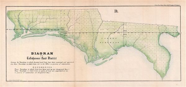
D. Diagram of Tallahassee Land District.
1855 (undated) 7.5 x 17 in (19.05 x 43.18 cm)
1855 (undated) 7.5 x 17 in (19.05 x 43.18 cm)
Description
An appealing 1855 Florida Land Office survey map of the Florida Panhandle. This map covers the panhandle from the Alabama Border to the Suwannee River. This map was drawn to illustrate the progress of the Florida Land Survey. The state of the Land Survey is noted via a series of blocks, those marked with an asterisk indicate that the survey is complete, a circle suggests work in progress, and unmarked blocks are planned but uninitiated surveys.
Forbes Purchase is also identified. This refers to a large tract of land in the Florida Panhandle that was purchased from Spain by three American traders in the late 18th century. After Florida became part of the United States there was an attempt by the government to seize this land, but it was shot down by the United States Supreme Court. Unfortunately, as Forbes Purchase was mostly uninhabitable swampland, it was impossible to develop and later sold off in lots.
Though lacking attribution, this map was most likely prepared by John Westcott, director of the Florida Land Office in 1855. It was engraved by A. Hoen and Company, government printers, in Baltimore, Maryland for issue in the 1856 congressional report, Maps and Views to Accompany Message and Documents 1855-56.
CartographerS
The General Land Office (1812 - 1946) was an independent agency charged with the administration and sale of public lands of the western territories of the United States under the Preemption Act of 1841 and the Homestead Act of 1862. During a time of frenetic energy and rapid westward expansion, the Land Office oversaw the surveying, platting, mapping and eventually the sale of much of the Western United States and Florida. The structural layout of the western United States that we see today, and many of their district and county divisions, are direct result of the early surveying work of the General Land Office. More importantly, as a branch of the Federal Government in Washington D.C. and the only agency able to legally sell and administer public lands in the western territories of the United States, the General Land Office played a pivotal role in consolidating power away from the original states and into the hands of the centralized federal government. The General Land Office was absorbed into the Department of Interior in 1849 and in 1946 merged with the United States Grazing Service to become the Bureau of Land Management. Today the Bureau of Land Management administers the roughly 246 million acres of public land remaining under federal ownership. More by this mapmaker...
August Hoen and Company (fl. c. 1840 - 1981) was a Baltimore based engraving and lithography firm active in the middle part of the 19th century. A. Hoen and Co. was originally founded by Edward Weber under the name 'E. Weber and Company.' Weber died in the early 1850s and his company was taken over by German immigrant August Hoen (18?? - 1886) and his brothers, Henry and Ernest Hoen. As general interest lithographers, the Hoen firm's corpus includes posters, cigar boxes, sheet music covers, and posters as well as maps. They are best known for their pioneering multi-color lithographic techniques. After the death of August Hoen, the business passed on to his son, Albert Hoen. Another son, Earnest A. Hoen, moved to Richmond, Virginia and opened a branch of the firm there where he was granted a charter to produce Civil War era Confederate Currency. Their contributions to the cartographic field are generally in association with engraving and printing work done for Jacob Monk and the U.S. Geological Survey. The Hoen family maintained an active interest in the firm for the next 100 years or so until it finally filed for bankruptcy in 1981. Learn More...
Source
Maps and Views to Accompany Message and Documents 1855-56, (Washington: Nicholson) 1856.
Condition
Very good. Original fold lines. Professionally flattened and backed with archival tissue. Some wear and toning on original fold lines.