Digital Image: 1917 'Yard-Long' Photographic View of Tampa, Florida
Tampa-fishbaugh-1934_d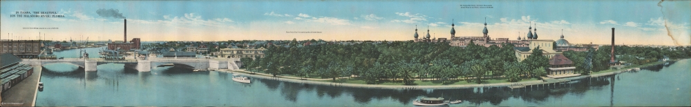

Title
In Tampa, 'The Beautiful,' (on the Hillsboro River,) Florida.
1934 (undated) 5.5 x 34.75 in (13.97 x 88.265 cm)
1934 (undated) 5.5 x 34.75 in (13.97 x 88.265 cm)
Description
FOR THE ORIGINAL ANTIQUE MAP, WITH HISTORICAL ANALYSIS, CLICK HERE.
Digital Map Information
Geographicus maintains an archive of high-resolution rare map scans. We scan our maps at 300 DPI or higher, with newer images being 600 DPI, (either TIFF or JPEG, depending on when the scan was done) which is most cases in suitable for enlargement and printing.
Delivery
Once you purchase our digital scan service, you will receive a download link via email - usually within seconds. Digital orders are delivered as ZIP files, an industry standard file compression protocol that any computer should be able to unpack. Some of our files are very large, and can take some time to download. Most files are saved into your computer's 'Downloads' folder. All delivery is electronic. No physical product is shipped.
Credit and Scope of Use
You can use your digial image any way you want! Our digital images are unrestricted by copyright and can be used, modified, and published freely. The textual description that accompanies the original antique map is not included in the sale of digital images and remains protected by copyright. That said, we put significant care and effort into scanning and editing these maps, and we’d appreciate a credit when possible. Should you wish to credit us, please use the following credit line:
Courtesy of Geographicus Rare Antique Maps (https://www.geographicus.com).
How Large Can I Print?
In general, at 300 DPI, you should at least be able to double the size of the actual image, more so with our 600 DPI images. So, if the original was 10 x 12 inches, you can print at 20 x 24 inches, without quality loss. If your display requirements can accommodate some loss in image quality, you can make it even larger. That being said, no quality of scan will allow you to blow up at 10 x 12 inch map to wall size without significant quality loss. For more information, it is best consult a printer or reprographics specialist.
Refunds
If the high resolution image you ordered is unavailable, we will fully refund your purchase. Otherwise, digital images scans are a service, not a tangible product, and cannot be returned or refunded once the download link is used.
Cartographer
William Arthur Fishbaugh (June 20, 1873 - November 3, 1950) was an early 20th-century American photographer. Fishbaugh was born in Ohio but had flair for adventure. He worked as a mounted police officer in South Africa as early as 1895. It was there that he developed a passion for photography. He moved to the Philippines to capture the Spanish-American War on film. He also developed, at this time, a focus on architectural photography. Later he moved to Tampa, where he operated a photo studio at 506 Franklin Street for about 10 years. In 1917 he moved to Miami, where he worked closely with real-estate developers to photograph and promote land development. His work captures the pioneering days of Miami and south Florida. In addition to his urban landscapes, he documented agricultural scenes, local Seminole Indians, and the burgeoning aviation industry. His work provides an invaluable historical record of south Florida's rapid transformation during the early 1900s. More by this mapmaker...