This item has been sold, but you can get on the Waitlist to be notified if another example becomes available, or purchase a digital scan.
1874 Sudo General Manuscript Map of Tamsui Harbor, Taiwan / Formosa
Tamsui-sudo-1874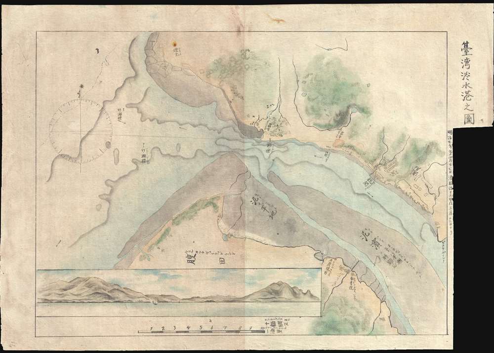

Title
台湾淡水港之图 / Map of Tamusi Harbor.
1874 (dated) 10.5 x 15 in (26.67 x 38.1 cm) 1 : 158000
1874 (dated) 10.5 x 15 in (26.67 x 38.1 cm) 1 : 158000
Description
Part of Sudo Collection. Not sold Separately: Click here for full collection.
A striking general map detailing the entrance to the Tamsui River and Tamsui Harbor, near modern day Taipei, Northern Taiwan. The map includes a large profile view illustrating the Tamsui River entrance and names the site of the British Consulate there. Tamsui has a long history of association with foreign activity in Taiwan. Early on it was an outpost of the Spanish, and later the Dutch. It rose to greater prominence in the 19th century for its fine natural harbor and proximity to the mainland port of Fuzhou, the Qing Fujian provincial capital and a major maritime trading center. In 1862, the Qing government opened Tamsui to foreign trade under the terms of the Treaty of Tientsin, exporting tea, camphor, sulfur, coal, opium, and dyes. By the mid-19th century Tamsui had become the largest port in Taiwan, boasting a sizable foreign population as well as a British consulate at Fort Santo Domingo. British activity in the region led to reliable nautical charts of the port and its immediate surroundings. Although we know little of Sudo, it is evident that he was in Tamsui in March of 1874, prior to the May Putative Expedition, and produced many if not all of these maps on location.
A striking general map detailing the entrance to the Tamsui River and Tamsui Harbor, near modern day Taipei, Northern Taiwan. The map includes a large profile view illustrating the Tamsui River entrance and names the site of the British Consulate there. Tamsui has a long history of association with foreign activity in Taiwan. Early on it was an outpost of the Spanish, and later the Dutch. It rose to greater prominence in the 19th century for its fine natural harbor and proximity to the mainland port of Fuzhou, the Qing Fujian provincial capital and a major maritime trading center. In 1862, the Qing government opened Tamsui to foreign trade under the terms of the Treaty of Tientsin, exporting tea, camphor, sulfur, coal, opium, and dyes. By the mid-19th century Tamsui had become the largest port in Taiwan, boasting a sizable foreign population as well as a British consulate at Fort Santo Domingo. British activity in the region led to reliable nautical charts of the port and its immediate surroundings. Although we know little of Sudo, it is evident that he was in Tamsui in March of 1874, prior to the May Putative Expedition, and produced many if not all of these maps on location.
Cartographer
Sudo Katsuzō (湏藤 / 湏藤勝三; c. 1848 - c. 1874) was a Japanese cartographer of Tochigi Prefecture (栃木県 / Tochigi-ken), Japan. Sudo was part of an 1874 mission to Taiwan and subsequently to the mainland of China. As part of this expedition, he produced a series of maps detailing Taiwan and some major cities in Fujian, including Fuzhou and Xiamen. The quality and execution of the maps suggest that he was experienced in both western and Japanese cartographic styles, indicating that he may have had training as a military engineer. Sudo apparently died of an unknown illness shortly after the maps were made, at just 26, so it is not surprising that little is recorded regarding his history. His maps were subsequently collected by his brother and remained in the family until recently. More by this mapmaker...
Condition
Very good. On thin Japanese paper. Manuscript.