This item has been sold, but you can get on the Waitlist to be notified if another example becomes available, or purchase a digital scan.
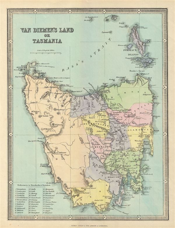
1857 Philip Map of Van Diemen's Land or Tasmania, Australia
Tasmania-philip-1857$75.00

Title
Van Diemen's Land or Tasmania.
1857 (undated) 12.5 x 9.5 in (31.75 x 24.13 cm) 1 : 1152000
1857 (undated) 12.5 x 9.5 in (31.75 x 24.13 cm) 1 : 1152000
Description
This is a beautiful 1857 map of Van Diemen's Land or Tasmania issued by George Philip and Sons. The map covers the entire island of Tasmania in considerable detail noting lakes, mountains, rivers, towns, parishes and other topographical features. Van Diemen's Land, was colonized by the British as a Penal Colony under the name 'Van Diemen's Land,' referring to the Dutch East India Company governor who sponsored Tasman's historic 1642 discovery of the island. In 1856, a year before this map was issued, Van Diemen's Land was granted responsible self-government and renamed 'Tasmania.' The map is color coded according to territories and regions. The lower left quadrant of the map features a list with references to Hundreds of Parishes. This map was issued by George Philip and Sons, London and Liverpool, in 1857.
Cartographer
George Philip (1800 - 1882) was a map publisher and cartographer active in the mid to late-19th century. Philip was born into a Calvinst family in Huntly, Aberdeenshire, Scotland. Around 1819 he apprenticed himself to William Grapel, a Liverpool printer and bookseller. Fifteen years later, in 1834, Philip founded his own Liverpool book and map firm. Philip's earliest cartographic ventures were mostly educational material issued in tandem with John Bartholomew Sr., August Petermann, and William Hughes. In 1848, Philip admitted his son, George Philip Jr. (1823 - 1902) into the firm, renaming it George Philip and Son Ltd. George Philip Jr. ran the firm until his death in 1902, by which time it had developed into a major publishing concern. His successors established the London Geographical Institute, a factory where they embraced modern printing techniques to produce thousands of economical and high quality maps. In April 1988, George Philip & Son was acquired by Octopus Publishing, a branch of Reed International. Nonetheless, today the firm trades and publishes to this day as George Philip and Son. More by this mapmaker...
Condition
Very good. Blank on verso.