
This item below is out of stock, but another example (left) is available. To view the available item, click "Details."
Details
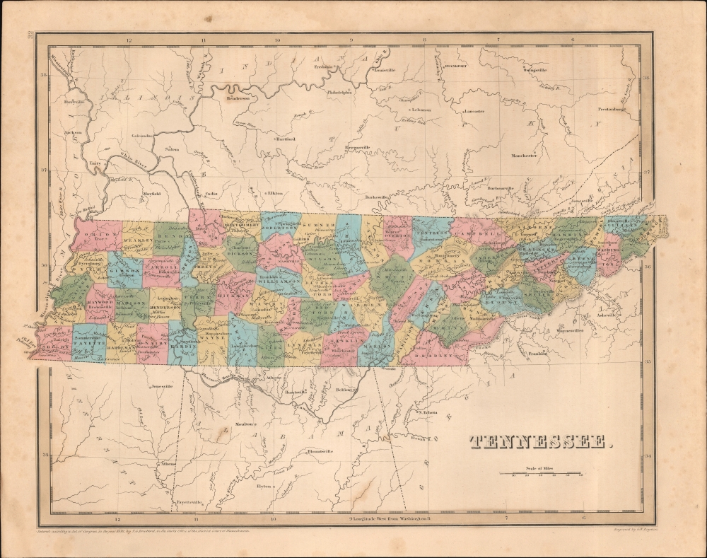
1846 Bradford Map of Tennessee
1846 (dated) $300.00
1838 Bradford Map of Tennessee
Tennessee-bradford-1838$150.00

Title
Tennessee.
1838 (dated) 12 x 14.5 in (30.48 x 36.83 cm) 1 : 2000000
1838 (dated) 12 x 14.5 in (30.48 x 36.83 cm) 1 : 2000000
Description
This is an 1838 Thomas G. Bradford map of Tennessee.
A Closer Look
The map embraces all of Tennessee as well as significant parts of adjacent states, particularly Kentucky. Here the state breaks the border of the map on both the east and west, allowing the cartographer to illustrate the state on the largest possible scale - given the page size. Tennessee in 1838 was rapidly growing, with new towns and settlements emerging constantly. Nonetheless, the state remained primary agricultural, with no railroad until Nashville and Chattanooga line of 1842.Historical Context - Slavery
Unlike many other southern states, Tennessee was not heavily dependent on slavery despite it still being part of the state's economy. This, and extensive migration from the north and east, fostered a growing abolitionist movement, with anti-slavery sentiment increasing in the state throughout the 1830s.Publication History and Census
This map was engraved by George Boynton in 1838 and published in the 1841 edition of Bradford and Goodrich's A Universal Illustrated Atlas. The map received regular updates through the late 1840s.CartographerS
Thomas Gamaliel Bradford (1802 - 1887) was born in Boston, Massachusetts, where he worked as an assistant editor for the Encyclopedia Americana. Bradford's first major cartographic work was his revision and subsequent republishing of an important French geography by Adrian Balbi, Abrege de Geographie published in America as Atlas Designed to Illustrate the Abridgment of Universal Geography, Modern and Ancient. Afterwards Bradford revised and expanded this work into his own important contributions to American cartography, the 1838 An Illustrated Atlas Geographical, Statistical and Historical of the United States and Adjacent Countries. Bradford's cartographic work is significant as among the first to record Texas as an independent nation. In his long career as a map publisher Bradford worked with William Davis Ticknor of Boston, Freeman Hunt of New York, Charles De Silver of Philadelphia, John Hinton, George Washington Boynton, and others. We have been able to discover little of Bradford's personal life. More by this mapmaker...
George Washington Boynton (fl. c. 1830 - 1850) was a Boston based cartographer and map engraver active in the first half of the 19th century. Boynton engraved and compiled maps for numerous publishers including Thomas Bradford, Nathaniel Dearborn, Daniel Adams, and S. G. Goodrich. His most significant work is most likely his engraving of various maps for Bradford's Illustrated Atlas, Geographical, Statistical, and Historical, of the United States and the Adjacent Countries and Universal Illustrated Atlas. He also engraved for the Boston Almanac. In 1835, Boynton is listed as an employee of the Boston Bewick Company, an engraving, stereotype, and printing concern based at no. 47 Court Street, Boston. Little else is known of his life. Learn More...
Source
Bradford, T. G. and Goodrich, S. G., A Universal Illustrated Atlas, exhibiting a Geographical, Statistical, and Historical view of the World, (Boston: Charles D. Strong) 1841.
The Universal Illustrated Atlas is one of the great American atlases of the first half of the 19th century. The atlas was first published in 1838 under the imprint of Charles D. Strong. It replaced and superseded Bradford's earlier smaller format Illustrated Atlas, Geographical, Statistical, and Historical, of the United States and the Adjacent Countries. Numerous reissues of the Universal Illustrated Atlas followed until about 1848. Although there are minor variations between the editions, most contain about 50 maps, the majority of which focus on the United States. Bradford's atlases are significant for recording North America during the Republic of Texas Era. In later editions, particularly the 1846 edition, Bradford illustrates the boom in railroad construction, possibly with the idea that his maps would aid travelers in planning journeys by rail. It was compiled by Thomas Gamaliel Bradford and Samuel Griswold Goodrich with most of the plates engraved by George Washington Boynton (fl. c. 1830 - 1850). Other contributors include Thomas Gordon (1778 - 1848), Fielding Lucas Jr. (1781 - 1854), Samuel Edward Stiles (1844 - 1901), Sherman and Smith (fl. c. 1829 - 1855), and Horace Thayer (1811 - c. 1874).
Condition
Very good. Even overall toning.
References
Rumsey 4453.030.