1876 Roessler Folding Geological Map of Texas
Texas-roessler-1876$5,500.00

Title
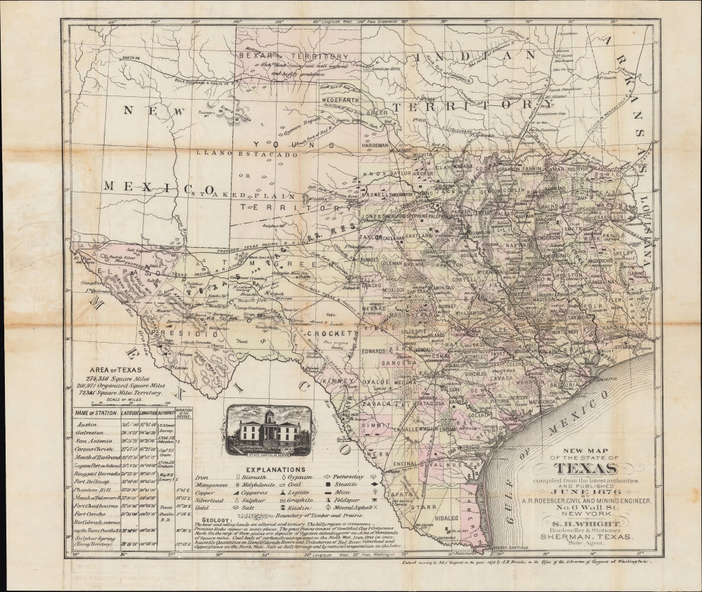
New Map of the State of Texas compiled from the Latest Authorities and Published June 1876.
1876 (dated) 17.25 x 19.25 in (43.815 x 48.895 cm) 1 : 315000
1876 (dated) 17.25 x 19.25 in (43.815 x 48.895 cm) 1 : 315000
Description
A significant 1876 map of Texas by mining engineer Anton Roessler highlighting railroads, minerals, and geological features. It captures the state's geography in a period of transition, on the cusp of transitions that accompanied the adoption of a new state constitution in 1876.
A Closer Look
Coverage includes the entirety of Texas, along with portions of New Mexico, the Indian Territory, Arkansas, and Louisiana. Waterways, terrain, cities, and other features are noted in splendid detail. Counties are color shaded for easy distinction. At bottom-left, latitude and longitude are provided for major stations (towns, ports, and forts) with the sources (authorities) on which Roessler relied to provide the coordinates and magnetic variations noted.Minerals and Mining
In 1874 Roessler wrote: 'Texas is, or will be, the wealthiest state in the Union, possessing as she does great agricultural capabilities, all the varieties of soils, minerals and useful rocks known to exist in the world.' Accordingly, the extensive legend focuses on minerals, including iron, copper, gold, coal, and lignite. The whole is a result of Roessler's background in geology and his groundbreaking work in the geological mapping of Texas. Descriptive notes, such as 'rich black loamy soil well watered and highly productive,' also give a sense of local geology. An illustration of the state capital building in Austin and the inclusion of both the Washington, D.C. and Greenwich Meridians add distinctive character.Railroads and Telegraphs
This map is also notable for displaying the rapid development of railroad and telegraph lines across the state, even in the sparsely populated western portion. Along a proposed route of the Texas and Pacific Railroad, large tracts of land ('reserves') along either side of the rail line are referred to.Transitory Territories
Perhaps most importantly, Roessler's map includes several territories and counties in the northern and western part of the state that would soon cease to exist or be reorganized. Most noticeable are the Young Territory and a rump Bexar Territory in the state's northwest. The Young Territory was divided into counties and ceased to exist in 1876, when Texas adopted a new constitution, making this a late representation of it. The short-lived Wegefarth County, created in 1873, also ceased to exist in 1876. Neighboring Greer County had been created but never been fully organized with an independent administration. Its status remained under dispute and was only resolved in 1896, when the U.S. Supreme Court ruled that it was territory of the federal government and belonged to the Indian Territory (soon to be Oklahoma). Several of the large counties in the western part of the state were only recently created, such as Tom Green County (1874), and would be subdivided continuously over the following decades.Publication History and Census
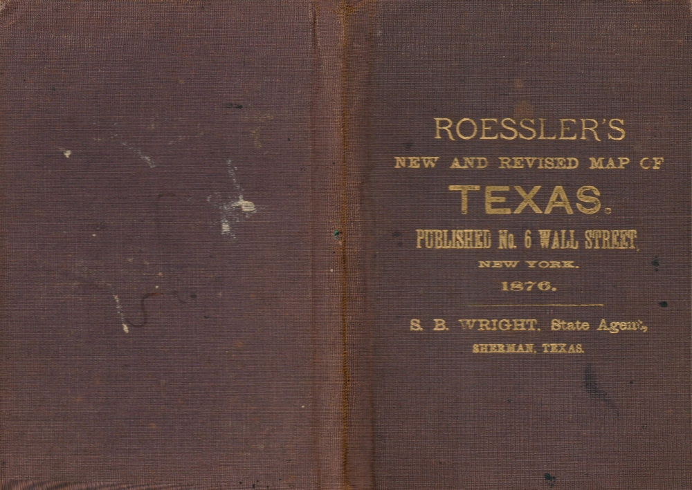
This map was copyrighted by Anton Roessler in 1875 and published the following year in New York. Roessler produced multiple maps of Texas in the mid-1870s that appeared in a variety of contexts, but this example, a separate-issue folding map with an accompanying binder, is rare. The closest presentation of the map we have been able to identify is noted in the OCLC (21730666) among the holdings of Brigham Young University, Rice University, the University of Texas, and the University of Houston, but those examples appear to be slightly smaller and are listed as including an inset of Galveston that is not present here.Cartographer
Anton R. Roessler (c. 1833 - 1893) was a surveyor and cartographer who played an important role in the mapping of Texas in the early statehood period. Little is known about his early life aside from his being born in the Austro-Hungarian Empire. He arrived in Texas in the late 1850s and spent most of his adult life in Austin. He participated in the 'Shumard Survey,' led by the chief geologist of the state, Benjamin Franklin Shumard. Roessler worked as a geological assistant and draughtman on the survey, which was disbanded due to the Civil War in 1862 (Roessler's maps are the only ones that survive from the Shumard Survey). Roessler then worked as chief draughtsman for the Texas State Military Board's arsenal. Towards the end of the war, he shifted to the Union side, moving to New Orleans and informing federal troops about Confederate defenses and the geography of Texas. After the war, he worked for the U.S. Land Office (General Land Office) and began to publish maps of Texas and of individual counties of Texas under his own name. He also published scholarly papers related to geology and, for a time, relocated to New York, where he worked to promote immigration to Texas through the Texas Land and Immigration Company of New York. Mystery and controversy surrounded Roessler. The records of the Shumard Survey all were lost or destroyed, save for those in Roessler's possession. He was later publicly attacked by State Geologist S. B. Buckley, who accused Roessler of hoarding the only remaining copies of the Survey's maps and using them for personal gain. More by this mapmaker...
Condition
Average to good. Toning and some loss at fold intersections. Margin tears closed and repaired on verso.