1590 Adrichem Map of the Tribe of Simeon, Israel (South of Canaan)
TribeSimeon-adrichem-1590$500.00

Title
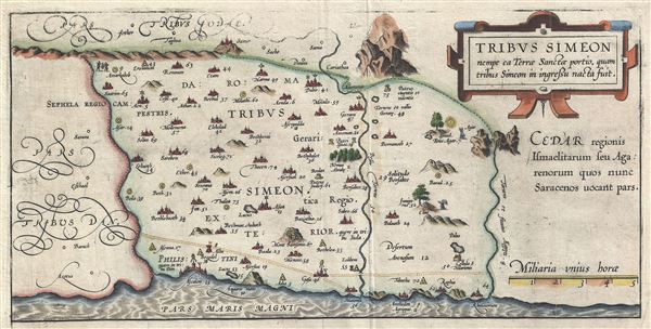
Tribus Simeon nempe ea Terrae Sanctae portio, quam tribus Simeon in ingressu nacta fuit.
1590 (undated) 7.5 x 14.5 in (19.05 x 36.83 cm)
1590 (undated) 7.5 x 14.5 in (19.05 x 36.83 cm)
Description
This is a fine example of Christian van Adrichem's rare 1590 map of the lands granted to the Tribe of Simeon at the time of Joshua's division of the Twelve Tribes. Oriented to the East and identifies the lands of the Philistines as well as timber lands rich in Cedar. The Tribe of Simeon occupied the region southwest of Canaan and was bounded by the lands granted to the Tribes of Dan and Judah. Numerous Biblical sites are noted throughout. This map is the tenth of ten maps of the Holy Land prepared by Christian van Adrichem for publication in his Theatrum Terrae Sanctae. Adrichem's maps for the Theatrum were prepared between 1580 and 1585, but were published posthumously by his associate, Gerardis Brunius of Koln, in 1590. The publication went through several later editions and served as a basis for most subsequent maps of the Holy Land well into the 18th century.
Cartographer
Christian Kruik van Adrichem (February 13, 1533 - June 20, 1585), alternatively known as Christianus Crucius Adrichomius was a Dutch theologian active in the second half of the 16th century. Adrichem was born in Delft of a wealthy family - at one point his father, Adriaen Claesz, was mayor of Delft. Adrichem was ordained in 1566. He served as the director of the Convent of St. Barbara in Delft until expelled by the Protestant Reformation. Fleeing the anti-Catholic sentiment of the Reformation, Adrichem reestablished himself in Cologne (Koln) where compiled various religious works including his important historical atlas, the Theatrum Terrae Sanctae et Biblicarum Historiarum. Adrichem's important atlas was published posthumously by his associate Gerardis Brunius in 1590. The work went through numerous editions and served as the foundation of most subsequent maps of the Holy Land well into the 18th century. More by this mapmaker...
Source
Adrichem, Christian van, Theatrum Terrae Sanctae et Biblicarum Historiarum (Gerardus Brunius, Koln) 1590.
Condition
Very good. Minor wear along original fold lines. Original platemark visible. Weak impression near top border.
References
Laor, E., Maps of the Holy Land: Cartobibliography of Printed Maps, 1475 - 1900, #18.