This item has been sold, but you can get on the Waitlist to be notified if another example becomes available, or purchase a digital scan.
1590 Adrichem Map of the Tribes of Zebulun, Issachar and Manasseh, Israel
TribesZebulunIssachar-adrichem-1590$250.00

Title
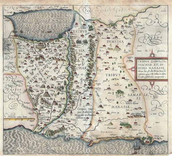
Tribus Zabulon, Isachar, et, Dimidia Manasse altera, hoc est, illae Tarrae Sanctae regiones, quas iste tribus in distribuendo possidendas acceperunt.
1590 (undated) 14.5 x 16.5 in (36.83 x 41.91 cm) 1 : 300000
1590 (undated) 14.5 x 16.5 in (36.83 x 41.91 cm) 1 : 300000
Description
This is a beautiful and rare 1590 example of Christian van Adrichem's map of the lands granted to the Tribes of Zabulon or Zebulun, Issachar or Isachar and the western half of the tribe of Manasseh at the time of Joshua's division of the Twelve Tribes. The map is oriented to the east and covers from the Sea of Galilee westward to the Mediterranean. Numerous Biblical illustrations include a dramatic scene where Jonas is being cast from a sailing ship into the open maw of the awaiting whale. This map, among the most attractive of the series, shows the Sea of Galilee in full with several scenes from the life of Jesus, including the walking on water episode, Jesus preaching from a boat, and others.
This map is the fourth of ten maps of the Holy Land prepared by Christian van Adrichem for publication in his Theatrum Terrae Sanctae. Adrichem's maps for the Theatrum were prepared between 1580 and 1585, but were published posthumously by his associate, Gerardis Brunius of Koln, in 1590. The publication went through several later editions and served as a basis for most subsequent maps of the Holy Land well into the 18th century.
This map is the fourth of ten maps of the Holy Land prepared by Christian van Adrichem for publication in his Theatrum Terrae Sanctae. Adrichem's maps for the Theatrum were prepared between 1580 and 1585, but were published posthumously by his associate, Gerardis Brunius of Koln, in 1590. The publication went through several later editions and served as a basis for most subsequent maps of the Holy Land well into the 18th century.
Cartographer
Christian Kruik van Adrichem (February 13, 1533 - June 20, 1585), alternatively known as Christianus Crucius Adrichomius was a Dutch theologian active in the second half of the 16th century. Adrichem was born in Delft of a wealthy family - at one point his father, Adriaen Claesz, was mayor of Delft. Adrichem was ordained in 1566. He served as the director of the Convent of St. Barbara in Delft until expelled by the Protestant Reformation. Fleeing the anti-Catholic sentiment of the Reformation, Adrichem reestablished himself in Cologne (Koln) where compiled various religious works including his important historical atlas, the Theatrum Terrae Sanctae et Biblicarum Historiarum. Adrichem's important atlas was published posthumously by his associate Gerardis Brunius in 1590. The work went through numerous editions and served as the foundation of most subsequent maps of the Holy Land well into the 18th century. More by this mapmaker...
Source
Adrichem, Christian van, Theatrum Terrae Sanctae et Biblicarum Historiarum (Gerardus Brunius, Koln) 1590.
Condition
Very good. Minor wear along original centerfold. Narrow bottom margin. Few dampstains near top margin. Minor printing crease, lower right and upper left quadrants.
References
Laor, E., Maps of the Holy Land: Cartobibliography of Printed Maps, 1475 - 1900, #12.