Digital Image: 1822 Admiralty Chart of Newfoundland from Trinity Harbor to Cape Freels
TrinityFreels-admiralty-1822_d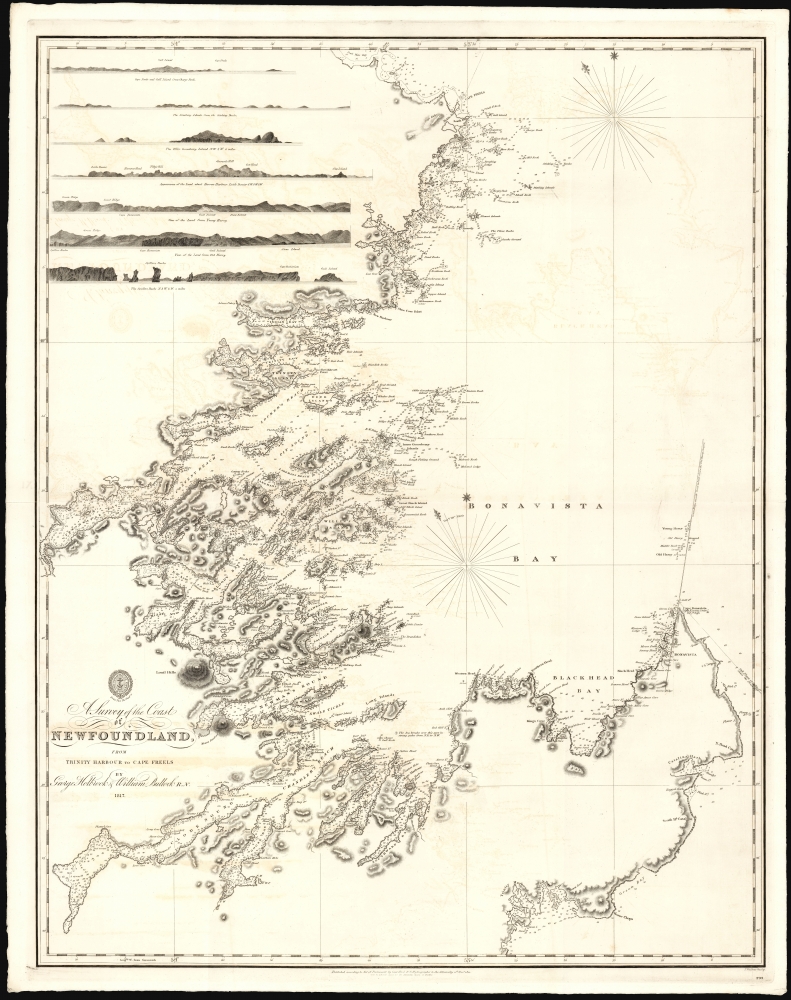


Title
A Survey of the Coast of Newfoundland from Trinity Harbour to Cape Freels.
1822 (dated) 31.5 x 24.5 in (80.01 x 62.23 cm) 1 : 1478340
1822 (dated) 31.5 x 24.5 in (80.01 x 62.23 cm) 1 : 1478340
Description
FOR THE ORIGINAL ANTIQUE MAP, WITH HISTORICAL ANALYSIS, CLICK HERE.
Digital Map Information
Geographicus maintains an archive of high-resolution rare map scans. We scan our maps at 300 DPI or higher, with newer images being 600 DPI, (either TIFF or JPEG, depending on when the scan was done) which is most cases in suitable for enlargement and printing.
Delivery
Once you purchase our digital scan service, you will receive a download link via email - usually within seconds. Digital orders are delivered as ZIP files, an industry standard file compression protocol that any computer should be able to unpack. Some of our files are very large, and can take some time to download. Most files are saved into your computer's 'Downloads' folder. All delivery is electronic. No physical product is shipped.
Credit and Scope of Use
You can use your digial image any way you want! Our digital images are unrestricted by copyright and can be used, modified, and published freely. The textual description that accompanies the original antique map is not included in the sale of digital images and remains protected by copyright. That said, we put significant care and effort into scanning and editing these maps, and we’d appreciate a credit when possible. Should you wish to credit us, please use the following credit line:
Courtesy of Geographicus Rare Antique Maps (https://www.geographicus.com).
How Large Can I Print?
In general, at 300 DPI, you should at least be able to double the size of the actual image, more so with our 600 DPI images. So, if the original was 10 x 12 inches, you can print at 20 x 24 inches, without quality loss. If your display requirements can accommodate some loss in image quality, you can make it even larger. That being said, no quality of scan will allow you to blow up at 10 x 12 inch map to wall size without significant quality loss. For more information, it is best consult a printer or reprographics specialist.
Refunds
If the high resolution image you ordered is unavailable, we will fully refund your purchase. Otherwise, digital images scans are a service, not a tangible product, and cannot be returned or refunded once the download link is used.
Cartographer S
William Bullock (January 12, 1797 - March 7, 1874) was a British naval officer, clergyman, and hymn writer. He was born in Essex, England, and died in Halifax, Nova Scotia. He was educated at a Bluecoat School (a school for the poor) in London. He entered the navy in 1815, during which he saw active duty in the bombardment of Algiers in 1816. Eventually, he became sailing master's mate and assistant surveyor aboard the Brig Snap, which did extensive hydrographic surveys around the coasts of Newfoundland - some in conjunction with George Papps Holbrook, future Surveyor General of Newfoundland. His ill health led to his discharge from the navy in 1821. During his service in Newfoundland, he came to believe the spiritual needs of the people of Newfoundland were not being met, and following his discharge, he chose to stay on in Newfoundland as a missionary for the Society for the Propagation of the Gospel. Bullock was ordained deacon in 1822 and raised to the priesthood two weeks later. He was appointed missionary at Trinity Bay, Newfoundland, in 1822. In 1823 he married Mary Clinch, daughter of the former missionary at Trinity; they had ten children. Bullock remained in Trinity as a successful and popular pastor, doctor, and magistrate until 1840. In 1841, he moved on to join a mission in Digby, Nova Scotia, where he built four new churches. He would become curate of St. Paul's Cathedral in Halifax in 1847. Eventually, he was appointed dean of the new cathedral of St. Luke, where he finally settled. In 1854, he published a collection of 166 hymns, one of which ('We love the place, O God') would be incorporated into the official hymnbook of the Church of England. More by this mapmaker...
George Papps Holbrook (1770 - March 18, 1832) was a British hydrographic surveyor who lived and worked in Newfoundland and Nova Scotia. He was born in Cornwall, England. Between 1814 and 1820, as a master in the Royal Navy, Holbrook commanded the Brig Sydney in order to survey the east coast of Newfoundland; between 1817 and 1820, he was assisted by astronomical surveyor William Bullock. He later commanded the Brig Snap, but would be relieved of that command in 1821. 1822 saw the birth of a son in Halifax. By the time of his death, he had become Surveyor General of Newfoundland. Learn More...