This item has been sold, but you can get on the Waitlist to be notified if another example becomes available, or purchase a digital scan.
1879 Henry Rawlinson Map of Turkmenistan and Iran
TurcomanSteppe-rawlinson-1879$75.00

Title
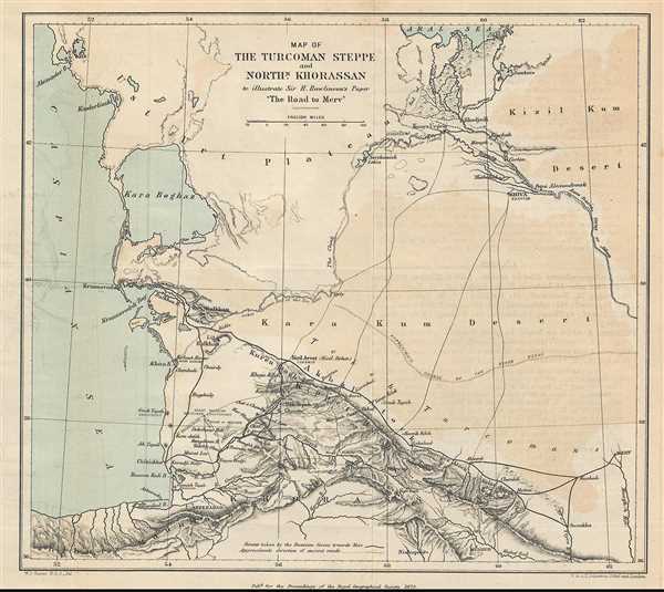
Map of the Turcoman Steppe and Northern Khorassan to illustrate Sir H. Rawlinson's paper 'The Road to Merv'
1879 (dated) 9 x 10 in (22.86 x 25.4 cm) 1 : 4306000
1879 (dated) 9 x 10 in (22.86 x 25.4 cm) 1 : 4306000
Description
This is a rare 1879 Sir Henry Rawlinson map of Turkmenistan and Iran. The map shows from the eastern Caspian Sea to the western half of Turkmenistan, which the map calls the Turcoman Steppe and from the Aral Sea to the northern reaches of Iran (Khorassan). This map shows the coast of the Caspian Sea in incredible detail, and includes the mountain ranges and both ancient and contemporary routes of rivers. Several towns and cities are labeled as well.
This map was made to accompany a paper given by Major General Henry Rawlinson entitled 'The Road to Merv' to the Royal Geographical Society. In his paper, General Rawlinson discusses both the ancient and contemporary geography of the region, as well as the current status of the Russian invasion of the region. This map shows the route taken by Russian troops, as well as General Rawlinson's proposed routes, since, at the time of the paper, the successful capture of Merv (the modern city of Mary, Turkmenistan) had not yet been achieved.
This map was drafted by W. J. Turner of the Royal Geographical Society and published by W. and A. K. Johnston for the Proceedings of the Royal Geographical Society in 1879.
Cartographer
Alexander Keith Johnston (December 28, 1804 - July 9, 1871) was a Scottish cartographer and map publisher active in the middle portion of the 19th century. Johnson was born at Kirkhill, near Edinburgh, Scotland. He studied at the University of Edinburgh where he apprenticed as an engraver. Around 1826, in partnership with his brother William, he founded a cartographic printing and engraving firm with the imprint "W. and A. K. Johnston." Johnston made a name for himself in educational geography, publishing numerous maps for use in schools. His brother, William Johnston, eventually left the firm to pursue a career in politics, eventually becoming the Lord Provost of Edinburgh. Alexander's son, who would bear the same name, became a geographer and explorer, suffering an untimely death on the Royal Geographical Society's 1879 expedition to Lake Nyasa. More by this mapmaker...
Source
Rawlinson, H.C., 'The Road to Merv', in Proceedings of the Royal Geographical Society and Monthly Record of Geography Vol.1, No. 3, March 1879.
Condition
Very good. Blank on verso.