1828 Arrowsmith Map of Northern Turkey in Europe
TurkeyEurope-arrowsmith-1828$100.00

Title
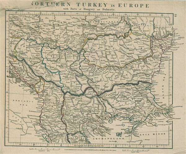
Northern Turkey in Europe with parts of Hungary and Dalmatia.
1828 (dated) 11 x 13 in (27.94 x 33.02 cm)
1828 (dated) 11 x 13 in (27.94 x 33.02 cm)
Description
This is a rare example of Aaron Arrowsmith's 1828 map of Turkey in Europe. The map covers Turkey or the Ottoman Empire as it extended into Europe during the early 19th century and includes the Balkan regions of Bosnia, Herzegovina, Monde Negro, Albania, Thessaly, Macedonia, Rumilia, Bulgaria, Walachia and Serbia. It also shows parts of Hungary, Transylvania and Dalmatia. The regional political boundaries are colored and relief shown by hachures. This map was published by A. Arrowsmith, hydrographer to His Majesty, in 1828.
Cartographer
Aaron Arrowsmith (1750-1823), John Arrowsmith (1790-1873), and Samuel Arrowsmith. The Arrowsmith family were noted map engravers, publishers, geographers, and cartographers active in the late 18th and early 19th century. The Arrowsmith firm was founded by Aaron Arrowsmith, who was trained in surveying and engraving under John Cary and William Faden. Arrowsmith founded the Arrowsmith firm as a side business while employed by Cary. The firm specialized in large format individual issue maps containing the most up to date and sophisticated information available. Arrowsmith's work drew the attention of the Prince of Wales who, in 1810, named him Hydrographer to the Prince of Wales, and subsequently, in 1820, Hydrographer to the King. Aaron Arrowsmith was succeeded by two sons, Aaron and Samuel, who followed him in the map publication business. The Arrowsmith firm eventually fell to John Arrowsmith (1790-1873), nephew of the elder Aaron. John was a founding member of the Royal Geographical Society. The firm is best known for their phenomenal large format mappings of North America. Mount Arrowsmith, situated east of Port Alberni on Vancouver Island, British Columbia, is named for Aaron Arrowsmith and his nephew John Arrowsmith. More by this mapmaker...
Condition
Very good. Original platemark visible. Blank on verso. Notable reapir work to damage on title and bottom right corner of map.