Digital Image: 1902 Harry H. Johnston Map of the Uganda Protectorate
UgandaProtectorate-manly-1902_d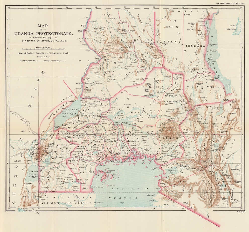

Title
Map of the Uganda Protectorate to illustrate the paper by Sir Harry Johnston, G.C.M.G., K.C.B.
1902 (dated) 17.5 x 18.5 in (44.45 x 46.99 cm) 1 : 2000000
1902 (dated) 17.5 x 18.5 in (44.45 x 46.99 cm) 1 : 2000000
Description
FOR THE ORIGINAL ANTIQUE MAP, WITH HISTORICAL ANALYSIS, CLICK HERE.
Digital Map Information
Geographicus maintains an archive of high-resolution rare map scans. We scan our maps at 300 DPI or higher, with newer images being 600 DPI, (either TIFF or JPEG, depending on when the scan was done) which is most cases in suitable for enlargement and printing.
Delivery
Once you purchase our digital scan service, you will receive a download link via email - usually within seconds. Digital orders are delivered as ZIP files, an industry standard file compression protocol that any computer should be able to unpack. Some of our files are very large, and can take some time to download. Most files are saved into your computer's 'Downloads' folder. All delivery is electronic. No physical product is shipped.
Credit and Scope of Use
You can use your digial image any way you want! Our digital images are unrestricted by copyright and can be used, modified, and published freely. The textual description that accompanies the original antique map is not included in the sale of digital images and remains protected by copyright. That said, we put significant care and effort into scanning and editing these maps, and we’d appreciate a credit when possible. Should you wish to credit us, please use the following credit line:
Courtesy of Geographicus Rare Antique Maps (https://www.geographicus.com).
How Large Can I Print?
In general, at 300 DPI, you should at least be able to double the size of the actual image, more so with our 600 DPI images. So, if the original was 10 x 12 inches, you can print at 20 x 24 inches, without quality loss. If your display requirements can accommodate some loss in image quality, you can make it even larger. That being said, no quality of scan will allow you to blow up at 10 x 12 inch map to wall size without significant quality loss. For more information, it is best consult a printer or reprographics specialist.
Refunds
If the high resolution image you ordered is unavailable, we will fully refund your purchase. Otherwise, digital images scans are a service, not a tangible product, and cannot be returned or refunded once the download link is used.
Cartographer
Harry Hamilton Johnston (June 12, 1858 - July 31, 1927) was a British explorer, linguist, artist, botanist, and colonial administrator who spoke several African languages. Born in London, Johnston attended King's College London and then studied painting at the Royal Academy for four years. He traveled to southern Angola in 1882 with the Earl of May, and he met Henry Morton Stanley in the Congo the next year. During that visit, he became one of the first Europeans after Stanley to see the Congo River above the Stanley Pool. In 1884, the Royal Geographical Society and the British Association appointed Johnston to lead a scientific expedition to Mount Kilimanjaro, during which he concluded treaties with local chiefs (succeeding where German efforts had not), to the advantage of the British East Africa Company to whom the treaties were transferred. Johnston became vice-consul in Cameroon and the Niger Delta in October 1886 and was promoted to acting consul in 1887. Throughout the 1880s and 1890s, Johnston played an important role in Britain's efforts during the Scramble for Africa, spending time in Katanga, Nyasaland, and North-Eastern Rhodesia. Johnston was appointed Knight Commander of the Order of Bath in 1896 and was transferred to Tunis to serve as consul-general, since he was suffering from 'tropical fevers' (malaria). Johnston was sent to Uganda to serve as special commissioner to reorganize the administration of that protectorate in 1899. He published over forty books on African subjects. He retired to Poling, in West Sussex, in 1906, and spent his retirement focused on literary endeavors. Between 1883 and 1915, he published roughly 190 maps of various parts of Africa, most in conjunction with the Royal Geographical Society or British War Office, but some privately with the Bartholomew firm. In 1925, Johnston suffered two strokes, from which he never fully recovered and became partially paralyzed. He died two years later. More by this mapmaker...
Source
Johnston, H., 'The Uganda Protectorate, Ruwenzori, and the Semliki Forest', The Geographical Journal, Vol. XIX No. 1 January 1902, (London: Royal Geographical Society) 1902.
References
OCLC 49359949, 243538858, 49580317.