1716 Homann Map of the Black Sea and Ukraine
Ukraine-homann-1716$650.00
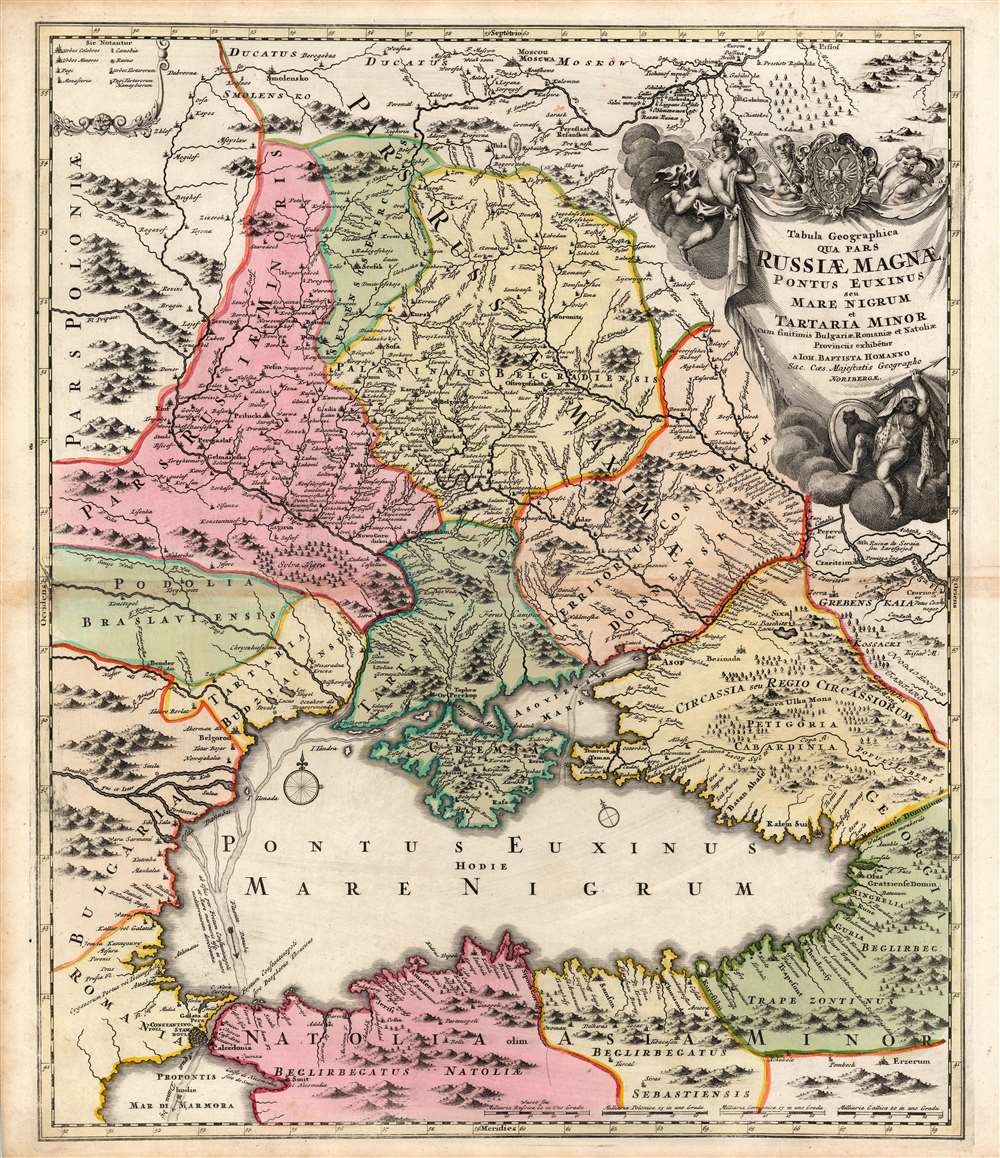

Title
Tabula Geographica qua pars Russiae Magnae, Pontus Euxinus, seu Mare Nigrum et Tartaria Minor cum finitimis Bulgariae, Romaniae, et Natoliae Provinciis exhibitur.
1716 (undated) 22.5 x 19 in (57.15 x 48.26 cm) 1 : 3100000
1716 (undated) 22.5 x 19 in (57.15 x 48.26 cm) 1 : 3100000
Description
This is a beautiful original color example of Johann Baptist Homann's 1716 map of the Black Sea region, including modern-day Ukraine, Moldova, and Russia. The map was produced during the reign of Peter the Great, when Russia actively warred with Sweden, the Crimean Tatars, and the Ottoman Turks. The region from the Don River on north to Moscow is here designated Russiae Maximae - or 'Greater Russia' thus expressing the extent of Peters ambitions.
The map is embellished with a superbly engraved cartouche, framed in clouds and surmounted with the arms of Imperial Russia. Flanking the Russian arms are a trio of putti, one helmed in imitation of Ares, and one all-too-enthusiastically brandishing a sword. At the foot of the cartouche, a dark-skinned putto sits upon a cloud wearing skins and waving an arrow. The owl-painted shield beside him indicates that this putto represents the Tatar Empire.
Peter the Great's Expansion to the Black Sea
Among the ambitious Peter's goals was to gain access to warm water ports: the only port at the beginning of his rule was Arkhangelsk, on the White Sea. The Baltic was controlled by Sweden, and the Black Sea and the Caspian were part of the Ottoman Empire and Safavid Empire, respectively. In the North, the Great Northern War (1700 - 1721) resulted in the founding of Saint Petersburg along with a significant decline in Swedish power. In the present map, Peter secured the passage of Kiev to Russia from Poland. Thereafter Peter waged war against the Crimean Khan Tatars and the Ottoman Sultan in effort to capture of the Ottoman fortress of Azov, thus controlling the mouth of the Don River - a feat he achieved in 1696. Homann has included crossed-sword symbols at several points to indicate important battles. One at the mouth of the Don corresponds to Peter's capture of Azov; another appears at the southwestern part of Tartaria Minor. The absence of such a symbol at Poltava is a strong indication that this map was engraved prior to the 1709 Battle of Poltava, the culminating battle of the Great Northern War.A Superb Engraving
The engraving is sophisticated and attractively executed, showing mountains evocatively and pictorially. In addition to the many rivers, Homann's map includes currents of those rivers as they extend into the Black Sea, and out into the Propontis.The map is embellished with a superbly engraved cartouche, framed in clouds and surmounted with the arms of Imperial Russia. Flanking the Russian arms are a trio of putti, one helmed in imitation of Ares, and one all-too-enthusiastically brandishing a sword. At the foot of the cartouche, a dark-skinned putto sits upon a cloud wearing skins and waving an arrow. The owl-painted shield beside him indicates that this putto represents the Tatar Empire.
Publication History and Census
This map was engraved as early as 1705 for inclusion in Homann's atlases. This example corresponds to 1716 editions of Homann's Atlas Novus Terrarum Orbis Imperia Regna.Cartographer
Johann Baptist Homann (March 20, 1664 - July 1, 1724) was the most prominent and prolific map publisher of the 18th century. Homann was born in Oberkammlach, a small town near Kammlach, Bavaria, Germany. As a young man, Homann studied in a Jesuit school and nursed ambitions of becoming a Dominican priest. Nonetheless, he converted to Protestantism in 1687, when he was 23. It is not clear where he mastered engraving, but we believe it may have been in Amsterdam. Homann's earliest work we have identified is about 1689, and already exhibits a high degree of mastery. Around 1691, Homann moved to Nuremberg and registered as a notary. By this time, he was already making maps, and very good ones at that. He produced a map of the environs of Nürnberg in 1691/92, which suggests he was already a master engraver. Around 1693, Homann briefly relocated to Vienna, where he lived and studied printing and copper plate engraving until 1695. Until 1702, he worked in Nuremberg in the map trade under Jacob von Sandrart (1630 - 1708) and then David Funck (1642 - 1709). Afterward, he returned to Nuremberg, where, in 1702, he founded the commercial publishing firm that would bear his name. In the next five years, Homann produced hundreds of maps and developed a distinctive style characterized by heavy, detailed engraving, elaborate allegorical cartouche work, and vivid hand color. Due to the lower cost of printing in Germany, the Homann firm could undercut the dominant French and Dutch publishing houses while matching their diversity and quality. Despite copious output, Homann did not release his first major atlas until the 33-map Neuer Atlas of 1707, followed by a 60-map edition of 1710. By 1715, Homann's rising star caught the attention of the Holy Roman Emperor Charles VI, who appointed him Imperial Cartographer. In the same year, he was also appointed a member of the Royal Academy of Sciences in Berlin. Homann's prestigious title came with several significant advantages, including access to the most up-to-date cartographic information as well as the 'Privilege'. The Privilege was a type of early copyright offered to very few by the Holy Roman Emperor. Though less sophisticated than modern copyright legislation, the Privilege offered limited protection for several years. Most all J. B. Homann maps printed between 1715 and 1730 bear the inscription 'Cum Priviligio' or some variation. Following Homann's death in 1724, the firm's map plates and management passed to his son, Johann Christoph Homann (1703 - 1730). J. C. Homann, perhaps realizing that he would not long survive his father, stipulated in his will that the company would be inherited by his two head managers, Johann Georg Ebersberger (1695 - 1760) and Johann Michael Franz (1700 - 1761), and that it would publish only under the name 'Homann Heirs'. This designation, in various forms (Homannsche Heirs, Heritiers de Homann, Lat Homannianos Herod, Homannschen Erben, etc.) appears on maps from about 1731 onwards. The firm continued to publish maps in ever-diminishing quantities until the death of its last owner, Christoph Franz Fembo (1781 - 1848). More by this mapmaker...
Source
Homann, J. B., Neuer Atlas bestehend in einig curieusen Astronomischen Kuppren und vielen auserlesenen accuratensten Land-Charten über die Gantze Welt, (Nuremberg: Homann), 1716.
Homann's Neuer Atlas bestehend in einig curieusen Astronomischen Kuppren und vielen auserlesenen accuratensten Land-Charten über die Gantze Welt was first publihsed in 1707 with 33 maps. A second edition followed in 1710 with 60 maps. Subsequent editions followed until about 1730. The title page notes proudly that the atlas features measurements based on the 'Copernican principle of the moving sky', a truly state-of-the-art innovation for the period. Regardless of editions, collations of the atlas are inconsistent, with some examples having less, while others have more maps - a consequence of the fact that the map sheets were delivered loose, to be bound at the buyer's discretion, and so some buyers chose to omit maps they did not consider relevant, or add others they did. Between editions, the constituent maps, particularly of European regions, were regularly updated to reflect the most recent political events. The atlas continued to be published by Homann's son, J. C. Homann (1703 - 1730), and then by Homann Heirs. Most examples also feature a fine allegorical frontispiece with the title Atlas Novus Terrarum Orbis Imperia, regna et Status, which was used for multiple Homann atlases, including the Neuer Atlas and the Atlas Minor.
Condition
Very good. Marginal mend, some toning along centerfold, else excellent with a bold strike and original wash and outline color.
References
OCLC 842204882 Rumsey 12499.192.