1857 Desilver Pocket Map of the United States
UnitedStates-desilver-1857$800.00

Title
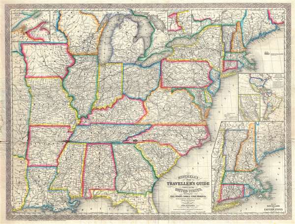
Mitchell's New Traveller's Guide through the United States Showing the Rail Roads, Canals, Stage Roads and c. with Distances from Place to Place.
1857 (dated) 22 x 29.5 in (55.88 x 74.93 cm) 1 : 3700000
1857 (dated) 22 x 29.5 in (55.88 x 74.93 cm) 1 : 3700000
Description
An uncommon separately issued 1857 pre-Civil War pocket map of the United States issued by Charles Desilver based on earlier maps by Samuel Augustus Mitchell. The map covers the United States from the Atlantic seaboard west to the first tier of states beyond the Mississippi, with insets offering additional detail in the New England Region, the Lake Superior Copper Mine Region, and in the California Gold Region. As might be anticipated from a map designed for the 'traveler,' Desilver offers exceptional detail with regard to railways, canals, and roads. It also offers an inset illustrates routes to California, emphasizing continued interest in the California gold discovery.
This map was drawn by J. L. Hazzard and I.S. Drake. Desilver first issued this map in 1856. This is the second Desilver edition, dated 1857. It is uncommon on the market.
This map was drawn by J. L. Hazzard and I.S. Drake. Desilver first issued this map in 1856. This is the second Desilver edition, dated 1857. It is uncommon on the market.
CartographerS
Charles Desilver (1815 - May 18, 1876) was an American book and map publisher active during the 19th century in Philadelphia. Desilver, the son of Thomas Desilver of the firm Desilver, Thomas and Co., began is cartographic career as a partner in the firm Thomas, Cowperthwait and Company, the publisher of Samuel Augustus Mitchell's popular New Universal Atlas. Thomas, Cowperthwait and Company was succeeded by Cowperthwait, Desilver and Butler. In 1856, when the previous firm dissolved, Desilver succeeded it by starting his own lithographic firm, acquired Mitchell's copyrights, and began publishing his own variant on the New Universal Atlas. Desilver revised Mitchell's maps with a new grillwork border, his own color scheme, new titles, and some updated political data. Despite a noble pedigree, Desilver's maps did not sell well - possibly because they followed the long and very popular run of Mitchell's own atlases. Desliver continued to publish his atlas until 1859 (though we have heard that he also published an 1862 edition). In 1859 he resold the Mitchell copyrights and printing plates to S. A. Mitchell's son S. A. Mitchell, Jr. The younger Mitchell again updated the plates with his own border and color scheme. He began publishing his own successful atlas in 1860. Desilver continued to operate his firm even after selling the Mitchell copyrights, and his sons Harry and Joseph T., joined the firm in 1875 which was renamed Desilver and Sons. Desilver married Caroline Hill on March 29, 1836, in Philadelphia, with whom he had several children. More by this mapmaker...
Samuel Augustus Mitchell (March 20, 1792 - December 20, 1868) began his map publishing career in the early 1830s. Mitchell was born in Bristol, Connecticut. He relocated to Philadelphia in 1821. Having worked as a school teacher and a geographical writer, Mitchell was frustrated with the low quality and inaccuracy of school texts of the period. His first maps were an attempt to rectify this problem. In the next 20 years Mitchell would become the most prominent American map publisher of the mid-19th century. Mitchell worked with prominent engravers J. H. Young, H. S. Tanner, and H. N. Burroughs before attaining the full copyright on his maps in 1847. In 1849 Mitchell either partnered with or sold his plates to Thomas, Cowperthwait and Company who continued to publish the Mitchell's Universal Atlas. By about 1856 most of the Mitchell plates and copyrights were acquired by Charles Desilver who continued to publish the maps, many with modified borders and color schemes, until Mitchell's son, Samuel Augustus Mitchell Junior, entered the picture. In 1859, S.A. Mitchell Jr. purchased most of the plates back from Desilver and introduced his own floral motif border. From 1860 on, he published his own editions of the New General Atlas. The younger Mitchell became as prominent as his father, publishing maps and atlases until 1887, when most of the copyrights were again sold and the Mitchell firm closed its doors for the final time. Learn More...
Condition
Good. Some wear and creasing on original fold lines. A few areas of repaired loss, lower left quadrant. Removed form binder, which is not present. Ready for framing.
References
OCLC 781473681.