
Desilver, Charles

Charles Desilver (1815 - May 18, 1876) was an American book and map publisher active during the 19th century in Philadelphia. Desilver, the son of Thomas Desilver of the firm Desilver, Thomas and Co., began is cartographic career as a partner in the firm Thomas, Cowperthwait and Company, the publisher of Samuel Augustus Mitchell's popular New Universal Atlas. Thomas, Cowperthwait and Company was succeeded by Cowperthwait, Desilver and Butler. In 1856, when the previous firm dissolved, Desilver succeeded it by starting his own lithographic firm, acquired Mitchell's copyrights, and began publishing his own variant on the New Universal Atlas. Desilver revised Mitchell's maps with a new grillwork border, his own color scheme, new titles, and some updated political data. Despite a noble pedigree, Desilver's maps did not sell well - possibly because they followed the long and very popular run of Mitchell's own atlases. Desliver continued to publish his atlas until 1859 (though we have heard that he also published an 1862 edition). In 1859 he resold the Mitchell copyrights and printing plates to S. A. Mitchell's son S. A. Mitchell, Jr. The younger Mitchell again updated the plates with his own border and color scheme. He began publishing his own successful atlas in 1860. Desilver continued to operate his firm even after selling the Mitchell copyrights, and his sons Harry and Joseph T., joined the firm in 1875 which was renamed Desilver and Sons. Desilver married Caroline Hill on March 29, 1836, in Philadelphia, with whom he had several children.
Europe during the Crimean War.
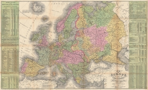
Map of Europe Compiled From the Latest Authorities.
$450.00
Acquire
- Digital Map Information
- Suitable for large format printing
- File Size: 34.39 MB
- File Type: ZIP / TIFF
- ICC color profile embedded
- Delivered instantly via download link
This is a separate issue 1854 Young and Cowperthwait map of Europe published during the Crimean War. Likely printed to capitalize on American interest in the war, Austrian gains in the Balkans in 'Servia' (Serbia) and Wallachia are outlined in red manuscript. (more details)
Rare Pre-Civil War Map of the United States illustrating California Gold Region.
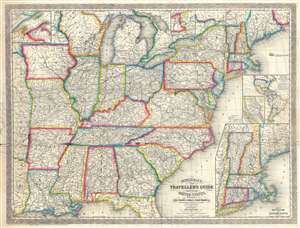
Mitchell's New Traveller's Guide through the United States Showing the Rail Roads, Canals, Stage Roads and c. with Distances from Place to Place.
$800.00
Acquire
- Digital Map Information
- Suitable for large format printing
- File Size: 27.38 MB
- File Type: ZIP / TIFF
- ICC color profile embedded
- Delivered instantly via download link
An uncommon separately issued 1857 pre-Civil War pocket map of the United States issued by Charles Desilver based on earlier maps by Samuel Augustus Mitchell. The map covers the United States from the Atlantic seaboard west to the first tier of states beyond the ... (more details)