This item has been sold, but you can get on the Waitlist to be notified if another example becomes available, or purchase a digital scan.
1846 Ensign and Thayer Wall Map of the United States w/ Texas, Florida, and Oregon Inset
UnitedStates-ensign-1846$1,750.00

Title
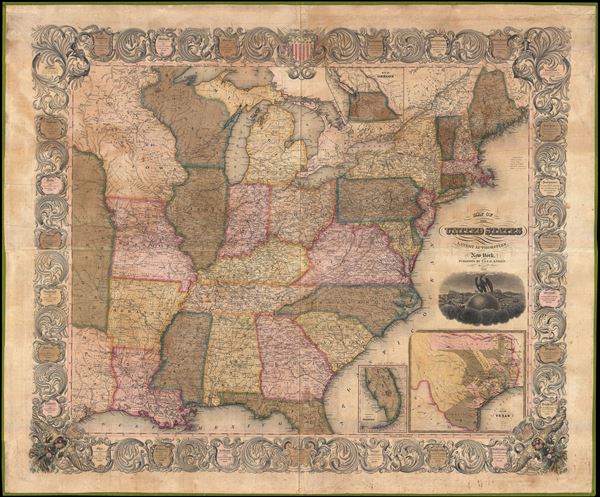
Map of the United States from the Best Authorities.
1846 (dated) 38.5 x 46 in (97.79 x 116.84 cm) 1 : 2901000
1846 (dated) 38.5 x 46 in (97.79 x 116.84 cm) 1 : 2901000
Description
A scarce 1846 wall map of the United States by Horace Thayer and Edward Ensign. This remarkable map covers the United Stated from Texas and the Upper Mississippi Valley eastward to the Atlantic and from Lake Superior to the Gulf of Mexico. Insets detail Oregon Territory and the newly admitted states of Florida and Texas. The map is surrounded by a decorative acanthus border framing miniature cartouches offering population and other details relative to each admitted state. The map is copyrighted to 1845, though we have not been able to identify any examples from that year. The date under the title cartouche is 1846, suggesting this to be the second edition, updated to reflect the December 1845 admittance of Texas and Florida into the Union.
The Texas inset in the lower left corner is notable for both its size and detail. The map presents Texas in an exceptionally ephemeral form reflecting the early Republic of Texas political geography. Here Texas extends westward off the map to include most of modern day New Mexico. Though not presented here, Texas at this time would also have included a long northern panhandle extending well into modern day Wyoming. The map offers an excellent county breakdown in eastern Texas with Austin, Galveston, San Antonio, and Houston, as well as a number of other early Texas cities, identified. The map sites the population of Texas around this time at a slight 140,000. The choice to not include the northern and western portions of Texas is suggestive of the Thomas Benton border reconfiguration plan which, though not adopted, would be formally presented to congress in 1850.
The present map is an exceptionally beautiful example and the only we are aware of to bear the 1846 imprint. The presumed third edition, which would follow in 1847, is more common. Published from offices at 36 Ann Street, New York City.
CartographerS
Edward Hooker Ensign (August 18, 1818 - July 10, 1871) was an American map and print publisher based in New York during the middle part of the 19th century. Edward was born in West Hartland, Connecticut. Little is known of Ensign's training but he may have inherited his business from his father, Timothy Ensign (1795 - 1859), who was a map publisher active in New York. Ensign seems to have had a flair for partnerships and variously published with Humphrey Phelps (1799 - 1875), Horace Thayer, Thomas C. Fanning (1805 - 1873) and Erastus C. Bridgman (1817 - 1870), among others. His various imprints include 'Phelps and Ensign' (1841-1844), 'T. and E. H. Ensign' (1844-1848), 'Ensign and Thayer' (1849), 'Ensign, Thayer, and Company' (1850-1851), 'Horace Thayer and Company' (1852), and 'Ensign, Bridgman and Fanning' (1854-1863). It appears that father and son worked together for some time as well, publishing as either 'T. and E. H. Ensign' or 'Ensigns'. At least some of these companies maintained offices in both Buffalo and New York City. More by this mapmaker...
Horace Thayer (June 29, 1811 - March 15, 1875) was a New York based publisher and lithographer active in New York City and Buffalo, New York, during the middle part of the 19th century. Thayer's publications focused on travel guides, wall, and pocket maps - many of which were based on the works of other American cartographers including J. H. Colton and S. A. Mitchell. In the 1840s, he partnered with the Hartford, Connecticut publisher Timothy Ensign (1795 - 1849) and later his son, Edward Hooker Ensign (1818 - 1871). According to map historian Walter Ristow, J. H. Colton's older son, George Washington Colton, partnered with Thayer in the late 1850s and early 1860s, possibly in order to learn Thayer's lithography techniques. Certainly a number of maps emerged bearing a 'Thayer and Colton' imprint. At various points Thayer also published with other prominent publishers and printmakers, publishing as Kelloggs and Thayer (1846 - 1847), Ensigns and Thayer (1848), Ensign and Thayer (1849 - 1850), and Ensign, Thayer, and Company (1850 - 1851), Phelps and Watson (1859), and Thayer and Colton (1859-186?). Thayer seems to have moved frequently and had offices at 50 Ann Street, 156 William Street, and at 18 Beekman Street, all in New York City. Learn More...
Condition
Very good condition. Professionally restored and stabilized. Attended by buy not attached to original wooden ferules.