
This item below is out of stock, but another example (left) is available. To view the available item, click "Details."
Details
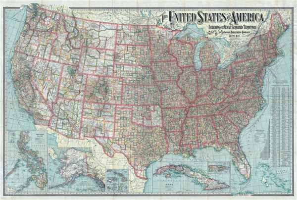
1902 National Publishing Map of the United States and Territories
1901 (dated) $550.00
1902 National Publishing Map of the United States and its Territories
UnitedStates-nationalpublishing-1902$275.00

Title
The United States of America Including All Its Newly Acquired Territory.
1902 (dated) 37 x 56 in (93.98 x 142.24 cm) 1 : 3294720
1902 (dated) 37 x 56 in (93.98 x 142.24 cm) 1 : 3294720
Description
This is a 1902 National Publishing Company map of the United States with an elaborate typograpical title. The map depicts the continental United States from the Pacific Ocean to the Atlantic Ocean and the Bahamas and from Canada to Mexico and the Gulf of Mexico. Each of the states and the territories are divided into counties, with myriad cities, towns, and villages labeled. The road network spreads across the country like a web, with major cities functioning as hubs. Shipping lanes are noted in the Atlantic and Pacific, with their destination and the company which operates on that route. Several inset maps are situated along the lower border, including Puerto Rico, Cuba, Hawaii, Wake Island, Guam, Samoa, Tutuila Island, Howland Island and Baker Island, Alaska (with a smaller inset of the western portion of the Aleutian Islands), and the Philippines. The Philippines, Cuba, and Puerto Rico are also divided into counties/districts, with each one labeled. Individual islands in the Philippine Archipelago are also labeled.
This map was published by The National Publishing Company of Boston, Massachusetts, in 1902.
This map was published by The National Publishing Company of Boston, Massachusetts, in 1902.
Condition
Very good. Wear along original fold lines. Professionally reinforced at fold separations and intersections on verso. Blank on verso
References
OCLC 24424003.