1902 National Publishing Map of the United States and Territories
UnitedStates-nationalpublishing-1901$550.00


Title
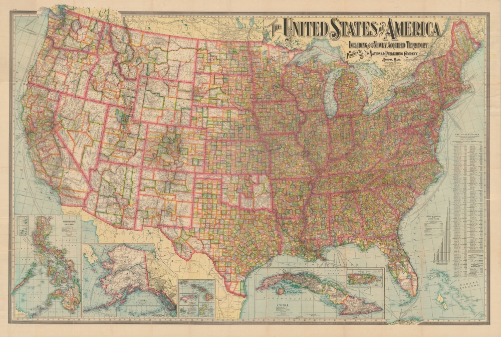
The United States of America Including All Its Newly Acquired Territory.
1901 (dated) 38.5 x 57 in (97.79 x 144.78 cm) 1 : 3294720
1901 (dated) 38.5 x 57 in (97.79 x 144.78 cm) 1 : 3294720
Description
This is a first edition 1901 National Publishing Company map of the United States that features a typographically elaborate title. It was issued in the wake of the Spanish-American War and consequently was updated to reflect American occupation of the Philippines.
A Closer Look
States and territories are divided into counties and the distinction between the developing western states, with enormous scarcely populated counties and the eastern states is made stark by the map's rich coloring. The road network spreads across the country like a web with major cities as hubs. Shipping lanes are noted in the Atlantic and Pacific, with each lane identified by destination and company. Several inset maps are situated along the lower border, including Puerto Rico, Cuba, Hawaii, Wake Island, Guam, Samoa, Tutuila Island, Howland Island and Baker Island, Alaska (with a smaller inset of the western portion of the Aleutian Islands), and the Philippines.Publication History and Census
This map was published by The National Publishing Company of Boston, Massachusetts, in 1901. A second edition was published in 1902 and on that edition the Bahamas in the lower right corner are replaced with a distance table. In 1902, the National Publishing Company merged with its sister company, the Scarborough Company. The Scarborough Company subsequently split this large map into separately published eastern and western sheets. Eight examples are cataloged in OCLC and are part of the collections at the Boston Public Library, the State Library of Massachusetts, the Library of Congress, the Osher Map Library at the University of Southern Maine, the University of Texas at Arlington, Washington State University, the Autry Museum of the American West in Los Angeles, and the University of California Berkeley.Cartographer
National Publishing Company (1897 - 1902) was an American map publishing firm founded in Portland, Maine in 1897. The founders, brothers Walter C. Scarborough (June 4, 1862 - May 9, 1904) and Howard G. Scarborough (December 23, 1867 - June 10, 1905), were also proprietors of the Scarborough Company and the Dominion Publishing Company. The National Publishing Company was intended to be managed by Howard, with Walter serving as treasurer. By 1901, the firm had relocated to Boston, where it published and sold large scale brilliantly printed road maps. In 1902, the Scarborough brothers merged their three concerns into the Boston based Scarborough Company and opened an office in Indianapolis, Indiana. Walter and Howard died in 1904 and 1905, both from tuberculous, but the Scarborough Company continued, transferring its offices to Indianapolis. In 1913 it became the Scarborough Motor Guide Company (c. 1913 - c. 1933). It does not appear to be related to the more prominent general publisher of the same name based out of Philadelphia. More by this mapmaker...
Condition
Good. Verso repairs to fold separations and at majority of fold intersections.
References
OCLC 79428085.