1942 Rand McNally / Army Information Branch Newsmap of the United States
UnitedStatesNewsmap-randmcnally-1942$250.00


Title
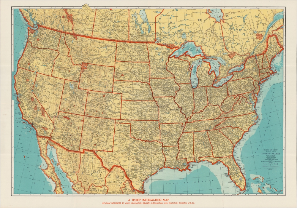
A Troop Information Map / Rand McNally Standard Map of United States.
1942 (undated) 27 x 36.75 in (68.58 x 93.345 cm) 1 : 5000000
1942 (undated) 27 x 36.75 in (68.58 x 93.345 cm) 1 : 5000000
Description
A curious, unrecorded c. 1942 Newsmap of the United States, based on an earlier Rand McNally map of the same. It is likely a very early Newsmap, distinct from the Army Information Branch's later output.
A Closer Look
The map covers the United States along with portions of Canada and Mexico, tracing state and national borders, national parks, and national monuments in red and heavily developed urban areas in black. Cities and towns, geographic features, highways, railways, canals, Indian Reservations, and other features are labeled throughout. The most interesting element of this map is the note at bottom, which indicates that this is part of the collection of Newsmaps published by the Army Information Branch during the Second World War. However, it differs significantly from other Newsmaps in the series, which were unique creations by the Army Information Branch, suggesting that this was an early production.Publication History and Census
This map was originally produced by Rand McNally in their Commercial Atlas. A map with this title appears in that atlas throughout the 1920s and 1940s, but the presentation of this map matches the 1938 edition, though this appears to be a larger format edition of that map. The map was republished by the Army Information Branch, likely in the weeks after the Pearl Harbor attack. This map, with the text at bottom, is not recorded among the holdings of any institution in the OCLC and does not appear in the Library of Congress' Newsmap collection.Cartographer
Rand, McNally and Co. (fl. 1856 - present) is an American publisher of maps, atlases and globes. The company was founded in 1856 when William H. Rand, a native of Quincy, Massachusetts, opened a print shop in Chicago. Rand hired the recent Irish immigrant Andrew McNally to assist in the shop giving him a wage of 9 USD per week. The duo landed several important contracts, including the Tribune's (later renamed the Chicago Tribune) printing operation. In 1872, Rand McNally produced its first map, a railroad guide, using a new cost effective printing technique known as wax process engraving. As Chicago developed as a railway hub, the Rand firm, now incorporated as Rand McNally, began producing a wide array of railroad maps and guides. Over time, the firm expanded into atlases, globes, educational material, and general literature. By embracing the wax engraving process, Rand McNally was able to dominate the map and atlas market, pushing more traditional American lithographic publishers like Colton, Johnson, and Mitchell out of business. Eventually Rand McNally opened an annex office in New York City headed by Caleb S. Hammond, whose name is today synonymous with maps and atlases, and who later started his own map company, C. S. Hammond & Co. Both firms remain in business. More by this mapmaker...
Source
Commercial Atlas of America, (Chicago: Rand McNally) 1938.
Newsmaps were published weekly between April 1942 and March 1946. Their content usually featured world maps, short summaries of the week’s military action, and photographs of troops and materiel. Early Newsmaps were printed on one side only, but, later in the war, they were printed on both sides, with the reverse bearing large-format maps, photographs, or other visual information. Several different versions of Newsmaps were produced: a large domestic version, a smaller overseas version, and an industrial version, which included more information about war production efforts. Two other editions appear in the United States Government Publications Monthly Catalogs, a 'Newsmap Special Edition' and a 'Newsmap Special Supplement for Special Training Units'.
Per the National Archives and Records Administration, ‘NEWSMAPS were not issued for general distribution. The posters were distributed to military installations, government and civilian groups working on War Department projects, and certain depository libraries, as designate by Congress, and one copy to Congressmen, if requested.’ The importance of the Newsmaps to the Army is related in the 1944 Basic Field Manual for The Special Service Company. The Manual states that as soon as the company reaches its destination ‘the company commander should contact the Special Service Branch in theater of operations headquarters, for copies of the weekly Newsmap.’ Also per the Manual
Per the National Archives and Records Administration, ‘NEWSMAPS were not issued for general distribution. The posters were distributed to military installations, government and civilian groups working on War Department projects, and certain depository libraries, as designate by Congress, and one copy to Congressmen, if requested.’ The importance of the Newsmaps to the Army is related in the 1944 Basic Field Manual for The Special Service Company. The Manual states that as soon as the company reaches its destination ‘the company commander should contact the Special Service Branch in theater of operations headquarters, for copies of the weekly Newsmap.’ Also per the Manual
The librarian should check the weekly Newsmap as soon as it is made available and should post it in a conspicuous place. He should take steps to see that the place where the Newsmap is posted is made known to all troops of the area in which the company or platoon is operating. This can be done effectively through notices in soldier newspapers, verbal announcements by those directly in charge of troops, and by posting announcements on bulletin boards.
Condition
Very good. Light wear along original folds.