Digital Image: 1942 Rand McNally / Army Information Branch Newsmap of the United States
UnitedStatesNewsmap-randmcnally-1942_d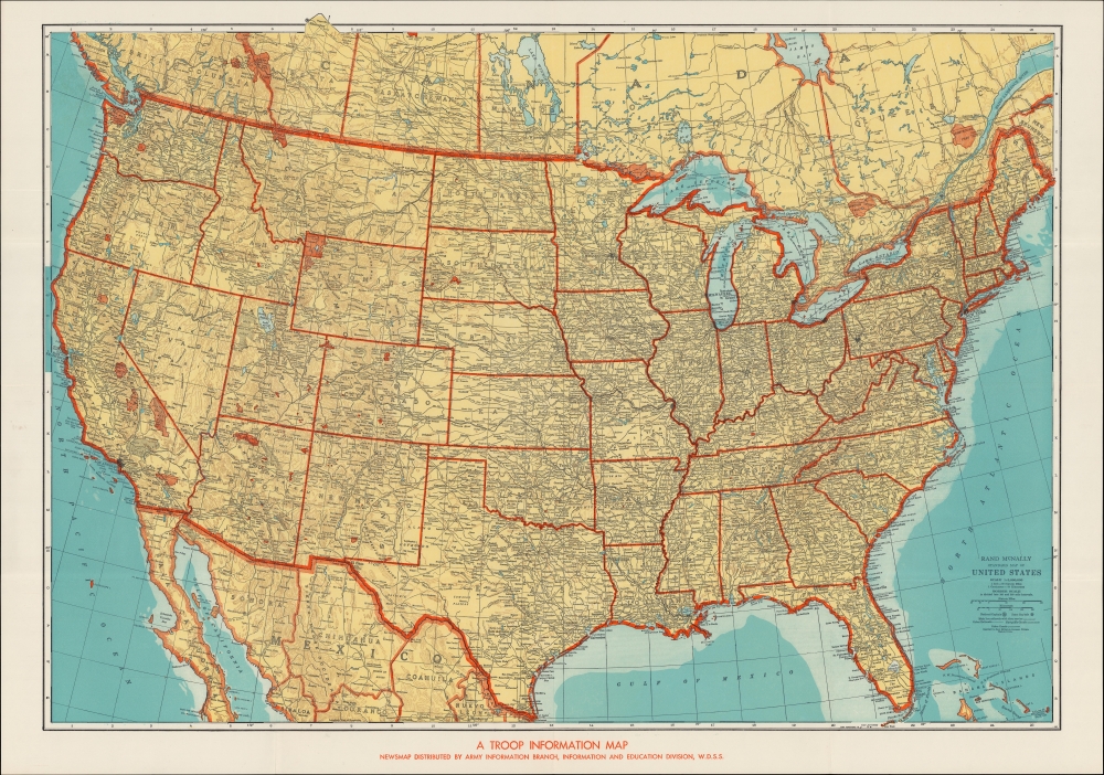


Title
A Troop Information Map / Rand McNally Standard Map of United States.
1942 (undated) 27 x 36.75 in (68.58 x 93.345 cm) 1 : 5000000
1942 (undated) 27 x 36.75 in (68.58 x 93.345 cm) 1 : 5000000
Description
FOR THE ORIGINAL ANTIQUE MAP, WITH HISTORICAL ANALYSIS, CLICK HERE.
Digital Map Information
Geographicus maintains an archive of high-resolution rare map scans. We scan our maps at 300 DPI or higher, with newer images being 600 DPI, (either TIFF or JPEG, depending on when the scan was done) which is most cases in suitable for enlargement and printing.
Delivery
Once you purchase our digital scan service, you will receive a download link via email - usually within seconds. Digital orders are delivered as ZIP files, an industry standard file compression protocol that any computer should be able to unpack. Some of our files are very large, and can take some time to download. Most files are saved into your computer's 'Downloads' folder. All delivery is electronic. No physical product is shipped.
Credit and Scope of Use
You can use your digial image any way you want! Our digital images are unrestricted by copyright and can be used, modified, and published freely. The textual description that accompanies the original antique map is not included in the sale of digital images and remains protected by copyright. That said, we put significant care and effort into scanning and editing these maps, and we’d appreciate a credit when possible. Should you wish to credit us, please use the following credit line:
Courtesy of Geographicus Rare Antique Maps (https://www.geographicus.com).
How Large Can I Print?
In general, at 300 DPI, you should at least be able to double the size of the actual image, more so with our 600 DPI images. So, if the original was 10 x 12 inches, you can print at 20 x 24 inches, without quality loss. If your display requirements can accommodate some loss in image quality, you can make it even larger. That being said, no quality of scan will allow you to blow up at 10 x 12 inch map to wall size without significant quality loss. For more information, it is best consult a printer or reprographics specialist.
Refunds
If the high resolution image you ordered is unavailable, we will fully refund your purchase. Otherwise, digital images scans are a service, not a tangible product, and cannot be returned or refunded once the download link is used.
Cartographer
Rand, McNally and Co. (fl. 1856 - present) is an American publisher of maps, atlases and globes. The company was founded in 1856 when William H. Rand, a native of Quincy, Massachusetts, opened a print shop in Chicago. Rand hired the recent Irish immigrant Andrew McNally to assist in the shop giving him a wage of 9 USD per week. The duo landed several important contracts, including the Tribune's (later renamed the Chicago Tribune) printing operation. In 1872, Rand McNally produced its first map, a railroad guide, using a new cost effective printing technique known as wax process engraving. As Chicago developed as a railway hub, the Rand firm, now incorporated as Rand McNally, began producing a wide array of railroad maps and guides. Over time, the firm expanded into atlases, globes, educational material, and general literature. By embracing the wax engraving process, Rand McNally was able to dominate the map and atlas market, pushing more traditional American lithographic publishers like Colton, Johnson, and Mitchell out of business. Eventually Rand McNally opened an annex office in New York City headed by Caleb S. Hammond, whose name is today synonymous with maps and atlases, and who later started his own map company, C. S. Hammond & Co. Both firms remain in business. More by this mapmaker...
Source
Commercial Atlas of America, (Chicago: Rand McNally) 1938.
Newsmaps were published weekly between April 1942 and March 1946. Their content usually featured world maps, short summaries of the week’s military action, and photographs of troops and materiel. Early Newsmaps were printed on one side only, but, later in the war, they were printed on both sides, with the reverse bearing large-format maps, photographs, or other visual information. Several different versions of Newsmaps were produced: a large domestic version, a smaller overseas version, and an industrial version, which included more information about war production efforts. Two other editions appear in the United States Government Publications Monthly Catalogs, a 'Newsmap Special Edition' and a 'Newsmap Special Supplement for Special Training Units'.
Per the National Archives and Records Administration, ‘NEWSMAPS were not issued for general distribution. The posters were distributed to military installations, government and civilian groups working on War Department projects, and certain depository libraries, as designate by Congress, and one copy to Congressmen, if requested.’ The importance of the Newsmaps to the Army is related in the 1944 Basic Field Manual for The Special Service Company. The Manual states that as soon as the company reaches its destination ‘the company commander should contact the Special Service Branch in theater of operations headquarters, for copies of the weekly Newsmap.’ Also per the Manual
Per the National Archives and Records Administration, ‘NEWSMAPS were not issued for general distribution. The posters were distributed to military installations, government and civilian groups working on War Department projects, and certain depository libraries, as designate by Congress, and one copy to Congressmen, if requested.’ The importance of the Newsmaps to the Army is related in the 1944 Basic Field Manual for The Special Service Company. The Manual states that as soon as the company reaches its destination ‘the company commander should contact the Special Service Branch in theater of operations headquarters, for copies of the weekly Newsmap.’ Also per the Manual
The librarian should check the weekly Newsmap as soon as it is made available and should post it in a conspicuous place. He should take steps to see that the place where the Newsmap is posted is made known to all troops of the area in which the company or platoon is operating. This can be done effectively through notices in soldier newspapers, verbal announcements by those directly in charge of troops, and by posting announcements on bulletin boards.