1846 Bradford Map of Upper Canada (Ontario)
UpperCanada-bradford-1846$275.00

Title
Upper Canada.
1846 (dated) 11.5 x 14 in (29.21 x 35.56 cm) 1 : 1980000
1846 (dated) 11.5 x 14 in (29.21 x 35.56 cm) 1 : 1980000
Description
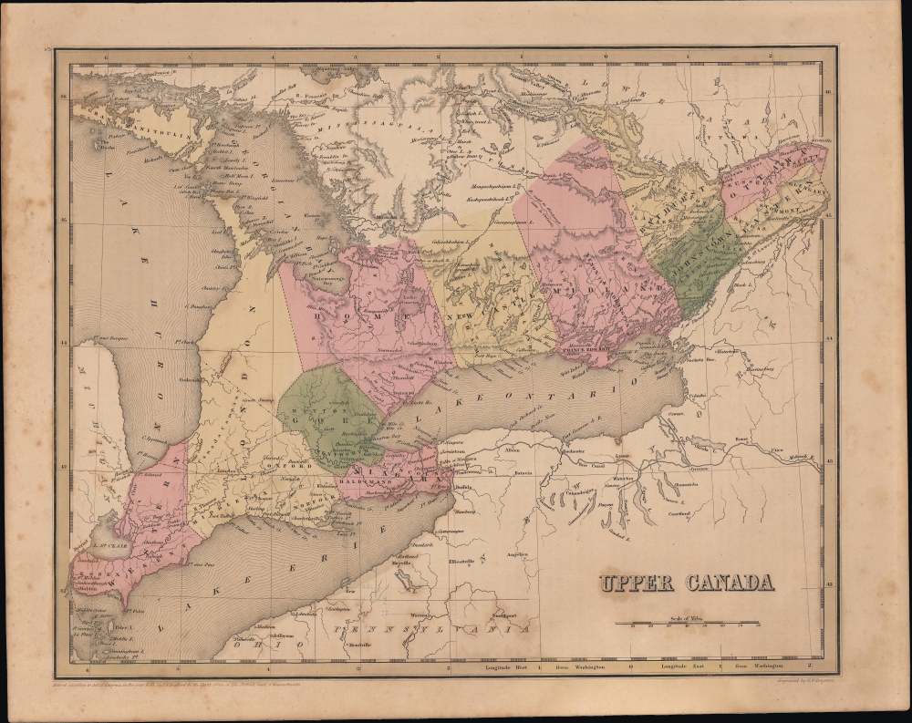
A nice example of Thomas Bradford's 1846 map of Upper Canada, concurrent with much of today's Ontario Province.
Still, intense opposition remained, with sporadic fighting by Quebecois patriotes continuing throughout the 1840s. At the same time, efforts to assuage separatist sentiment (namely the Rebellion Losses Bill) incensed British Tories, who felt they were being asked to compensate rebels for losses in a war they had initiated. The Tories group went so far as to riot and burn down the Parliament Building of the new province in Montreal in 1849, causing the government to relocate the capital of Canada to Toronto.
A Closer Look
Ranging from Lake St. Claire and the border with the United States of America at Detroit in the west to Ottawa in the east. Districts are color shaded for easy distinction, with some indicating internal administrative divisions (counties) with dashed lines. Toronto appears on the banks of Lake Ontario near center; the city was growing rapidly at this time but also suffered some of the effects of rapid urbanization, including fires (a large one in 1849), ethnic tension, and political unrest. Aside from settlements, geographic features (mountains, lakes, and rivers) are indicated throughout, with some revealing the still-uncertain geographic knowledge of the northern parts of the province (as with 'R. said to discharge into L. Ontario'). A tract of land at left along Lake Huron is noted as belonging to the Canada Company, which was chartered by the Crown and Parliament in 1826 to spur the colonization of Upper Canada.Historical Context
Canadian provinces and territories were under British and French control from the 16th century, until France gave up its claims in the Treaty of Paris in 1763. In 1791, under the Constitutional Act, the Province of Quebec was divided into Upper and Lower Canada. When this map was produced, the British were reeling from armed uprisings in both Lower Canada and Upper Canada in 1837-1838. Following the suppression of the rebellions and imposition of martial law, Lower Canada was united with Upper Canada as the Province of Canada in 1840, largely to dilute the political power of the French-speaking community. (They continued to be informally referred to as Upper and Lower Canada, or 'Canada West' and 'Canada East,' explaining the terminology used here.)Still, intense opposition remained, with sporadic fighting by Quebecois patriotes continuing throughout the 1840s. At the same time, efforts to assuage separatist sentiment (namely the Rebellion Losses Bill) incensed British Tories, who felt they were being asked to compensate rebels for losses in a war they had initiated. The Tories group went so far as to riot and burn down the Parliament Building of the new province in Montreal in 1849, causing the government to relocate the capital of Canada to Toronto.
Publication History
Despite the date of the copyright at bottom-left, this map (engraved by George Washington Boynton) was published in the 1846 edition of Bradford's Universal Illustrated Atlas.CartographerS
Thomas Gamaliel Bradford (1802 - 1887) was born in Boston, Massachusetts, where he worked as an assistant editor for the Encyclopedia Americana. Bradford's first major cartographic work was his revision and subsequent republishing of an important French geography by Adrian Balbi, Abrege de Geographie published in America as Atlas Designed to Illustrate the Abridgment of Universal Geography, Modern and Ancient. Afterwards Bradford revised and expanded this work into his own important contributions to American cartography, the 1838 An Illustrated Atlas Geographical, Statistical and Historical of the United States and Adjacent Countries. Bradford's cartographic work is significant as among the first to record Texas as an independent nation. In his long career as a map publisher Bradford worked with William Davis Ticknor of Boston, Freeman Hunt of New York, Charles De Silver of Philadelphia, John Hinton, George Washington Boynton, and others. We have been able to discover little of Bradford's personal life. More by this mapmaker...
George Washington Boynton (fl. c. 1830 - 1850) was a Boston based cartographer and map engraver active in the first half of the 19th century. Boynton engraved and compiled maps for numerous publishers including Thomas Bradford, Nathaniel Dearborn, Daniel Adams, and S. G. Goodrich. His most significant work is most likely his engraving of various maps for Bradford's Illustrated Atlas, Geographical, Statistical, and Historical, of the United States and the Adjacent Countries and Universal Illustrated Atlas. He also engraved for the Boston Almanac. In 1835, Boynton is listed as an employee of the Boston Bewick Company, an engraving, stereotype, and printing concern based at no. 47 Court Street, Boston. Little else is known of his life. Learn More...
Source
Bradford, T. G. and Goodrich, S. G., A Universal Illustrated Atlas, exhibiting a Geographical, Statistical, and Historical view of the World, (Boston: Charles D. Strong) 1846.
The Universal Illustrated Atlas is one of the great American atlases of the first half of the 19th century. The atlas was first published in 1838 under the imprint of Charles D. Strong. It replaced and superseded Bradford's earlier smaller format Illustrated Atlas, Geographical, Statistical, and Historical, of the United States and the Adjacent Countries. Numerous reissues of the Universal Illustrated Atlas followed until about 1848. Although there are minor variations between the editions, most contain about 50 maps, the majority of which focus on the United States. Bradford's atlases are significant for recording North America during the Republic of Texas Era. In later editions, particularly the 1846 edition, Bradford illustrates the boom in railroad construction, possibly with the idea that his maps would aid travelers in planning journeys by rail. It was compiled by Thomas Gamaliel Bradford and Samuel Griswold Goodrich with most of the plates engraved by George Washington Boynton (fl. c. 1830 - 1850). Other contributors include Thomas Gordon (1778 - 1848), Fielding Lucas Jr. (1781 - 1854), Samuel Edward Stiles (1844 - 1901), Sherman and Smith (fl. c. 1829 - 1855), and Horace Thayer (1811 - c. 1874).
Condition
Good. Light foxing and soiling.
References
Rumsey 4453.004 (1841 edition).