Digital Image: 1945 VIII Army Corps Unit Route Map of the VIII Corps in the European Theater During
VIIICorpsETO-viiicorps-1945_d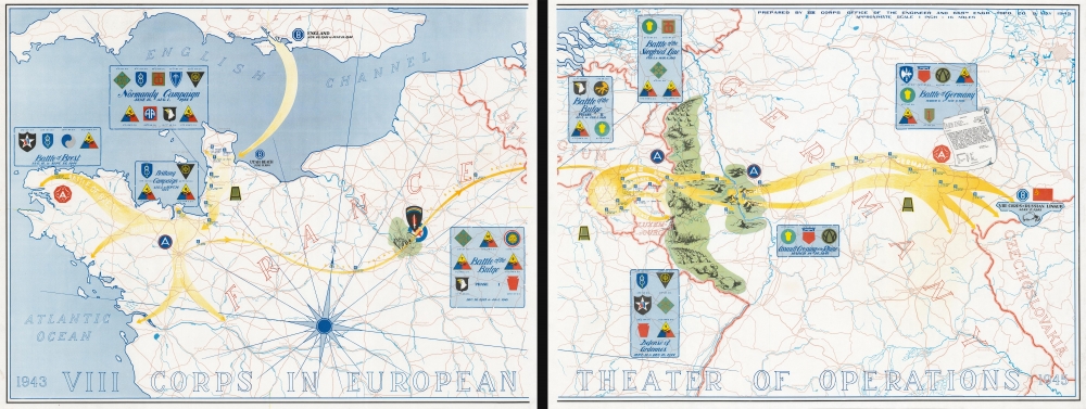


Title
1943 VIII Corps in the European Theater of Operations 1945.
1945 (dated) 21.25 x 56 in (53.975 x 142.24 cm) 1 : 1013760
1945 (dated) 21.25 x 56 in (53.975 x 142.24 cm) 1 : 1013760
Description
FOR THE ORIGINAL ANTIQUE MAP, WITH HISTORICAL ANALYSIS, CLICK HERE.
Digital Map Information
Geographicus maintains an archive of high-resolution rare map scans. We scan our maps at 300 DPI or higher, with newer images being 600 DPI, (either TIFF or JPEG, depending on when the scan was done) which is most cases in suitable for enlargement and printing.
Delivery
Once you purchase our digital scan service, you will receive a download link via email - usually within seconds. Digital orders are delivered as ZIP files, an industry standard file compression protocol that any computer should be able to unpack. Some of our files are very large, and can take some time to download. Most files are saved into your computer's 'Downloads' folder. All delivery is electronic. No physical product is shipped.
Credit and Scope of Use
You can use your digial image any way you want! Our digital images are unrestricted by copyright and can be used, modified, and published freely. The textual description that accompanies the original antique map is not included in the sale of digital images and remains protected by copyright. That said, we put significant care and effort into scanning and editing these maps, and we’d appreciate a credit when possible. Should you wish to credit us, please use the following credit line:
Courtesy of Geographicus Rare Antique Maps (https://www.geographicus.com).
How Large Can I Print?
In general, at 300 DPI, you should at least be able to double the size of the actual image, more so with our 600 DPI images. So, if the original was 10 x 12 inches, you can print at 20 x 24 inches, without quality loss. If your display requirements can accommodate some loss in image quality, you can make it even larger. That being said, no quality of scan will allow you to blow up at 10 x 12 inch map to wall size without significant quality loss. For more information, it is best consult a printer or reprographics specialist.
Refunds
If the high resolution image you ordered is unavailable, we will fully refund your purchase. Otherwise, digital images scans are a service, not a tangible product, and cannot be returned or refunded once the download link is used.
Cartographer
The 665th Engineer Topographic Battalion (December 17, 1943 - December 1946) was part of the U.S. Army during World War II and provided technical support in the form of surveying, drafting, and map production. Activated on December 17, 1943, at Fort McCoy, Wisconsin, the battalion initially consisted of twenty-eight men and an officer from the 650th Engineer Topographical Battalion, and five other officers from other units. Members of the unit had participated in the Army Specialized Training Program and had experience in topographical survey and mapping processes along with photomapping and reproduction techniques. The battalion was also supplemented with personnel who had received the necessary training as civilians. The unit spent the almost all of 1944 training in the United States, which included marksmanship drills, chemical warfare, and demolition instruction, along with winter training exercises in Wisconsin testing the army's newest winter clothing. The battalion embarked for Europe in New York City on December 8, 1944, and arrived two weeks later in Avonmouth, England. It left for the Theater of Operations from Southampton on January 30, 1945, and deployed to Belgium where it set up operations in Altembrouck, Belgium, and Castle Mheer in Mheer, Holland. Once their equipment was ready, the battalion began creating topography mapos from aerial photographs and ground survey information for the Ninth Army. It produced over 3,000,000 impressions in the first month. They moved to Hoensbroek, Holland, with map storage and distribution staying in Maastricht, Holland. Two weeks later the battalion moved to Mönchengladbach, Germany. The unit moved several more times in March and April 1945 to remain near the Ninth Army headquarters. After the war in Europe ended, the 665th continued making maps and conducting surveys for the Occupation forces. By mid-June the battalion had moved back to France in preparation for redeployment to the Pacific. However, the war in the Pacific ended before they left France. Some of the men in the unit (those with enough points) were discharged starting in October while the rest were transitioned to Occupation duty. The unit was deactivated in December 1946. More by this mapmaker...
References
OCLC 38763673, 1014003051.