Digital Image: 1725 Engelbrecht Map and View of Venice, Italy
Venetia-engelbrecht-1725_d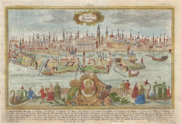

Title
Venetia Venedig.
1725 (undated) 9 x 12 in (22.86 x 30.48 cm)
1725 (undated) 9 x 12 in (22.86 x 30.48 cm)
Description
FOR THE ORIGINAL ANTIQUE MAP, WITH HISTORICAL ANALYSIS, CLICK HERE.
Digital Map Information
Geographicus maintains an archive of high-resolution rare map scans. We scan our maps at 300 DPI or higher, with newer images being 600 DPI, (either TIFF or JPEG, depending on when the scan was done) which is most cases in suitable for enlargement and printing.
Delivery
Once you purchase our digital scan service, you will receive a download link via email - usually within seconds. Digital orders are delivered as ZIP files, an industry standard file compression protocol that any computer should be able to unpack. Some of our files are very large, and can take some time to download. Most files are saved into your computer's 'Downloads' folder. All delivery is electronic. No physical product is shipped.
Credit and Scope of Use
You can use your digial image any way you want! Our digital images are unrestricted by copyright and can be used, modified, and published freely. The textual description that accompanies the original antique map is not included in the sale of digital images and remains protected by copyright. That said, we put significant care and effort into scanning and editing these maps, and we’d appreciate a credit when possible. Should you wish to credit us, please use the following credit line:
Courtesy of Geographicus Rare Antique Maps (https://www.geographicus.com).
How Large Can I Print?
In general, at 300 DPI, you should at least be able to double the size of the actual image, more so with our 600 DPI images. So, if the original was 10 x 12 inches, you can print at 20 x 24 inches, without quality loss. If your display requirements can accommodate some loss in image quality, you can make it even larger. That being said, no quality of scan will allow you to blow up at 10 x 12 inch map to wall size without significant quality loss. For more information, it is best consult a printer or reprographics specialist.
Refunds
If the high resolution image you ordered is unavailable, we will fully refund your purchase. Otherwise, digital images scans are a service, not a tangible product, and cannot be returned or refunded once the download link is used.
Cartographer S
Martin Engelbrecht (1684-1756) and his brother Christian were artists, print sellers, and engravers based in Augsburg, Germany, during the first half of the 18th Century. The Engelbrecht firm was established in 1717 and produced more than 5,000 printed. Among their work are city views issued by Friedrich Bernhard Werner and others. The duo are better known for creating miniature diorama cards which, inserted into a display box offered religious scenes from a three dimensional perspective. They are the only engravers to have been granted a royal permission to produce such scenes – which at the time seemed magical. They also produced portraits of monarchs and other local dignitaries. The work of the Engelbrecht brothers has been called "beyond compare." The Engelbrecht firm launched the careers of several other artists, including Jeremias Wachsmuht and Johann David Nessenthaler. More by this mapmaker...
Friedrich Bernhard Werner (1690-1778) was a German-born civil engineer, trained in Nice, who went on to become an accomplished copper-plate engraver, interested in subjects of cityscapes, monuments, churches, and public works. During the mid-18th century Werner travelled extensively in Central Europe documenting the architecture of its most prominent cities. Learn More...