1809 Nautical Chart or Map of the Harbor of Veracruz, Mexico
VeracruzHarbor-blunt-1809$175.00

Title
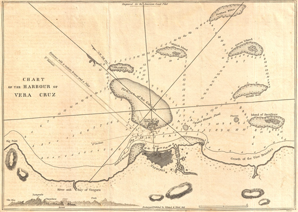
Chart of the Harbour of Vera Cruz.
1809 (dated) 8.5 x 11.75 in (21.59 x 29.845 cm)
1809 (dated) 8.5 x 11.75 in (21.59 x 29.845 cm)
Description
A fine 1809 nautical chart of the Harbor of Veracruz, Mexico by the American nautical chart publisher Eli Blunt. This map identifies the Reef of the Gallician, Island of Sacrifices, Green Island, Whitish Island, river and bay of Vergara, along with the fort of San Juan de Ulua and the city of Veracruz. Includes some depth soundings and relief shown by hachures. Issued in the 1809 edition of Blunt's American Coast Pilot.
Cartographer
Edmund March Blunt (June 20, 1770 - 1862) was an American navigator, bookseller, chartmaker, and cartographer based in Newburyport, Massachusetts. Blunt was born in Portsmouth, New Hampshire in 1770. In 1796, along with the nominal assistance of prominent navigator Captain Lawrence Furlong, Blunt published The American Coast Pilot, one of the most important published works on American navigation. Although much of the work was plagiarized from British publications, the Coast Pilot was an immediate popular success. In response to the popularity of his work, Blunt published 21 subsequent editions, each with important updates and revisions. The first edition to contain map plates was printed in 1804. Following a fire that destroyed his offices at The Sign of the Bible in 1811, Blunt moved his business to New York and opened a new shop, The Sign of the Quadrant. His sons Edmund Jr. (1799 - 1866) and George William (1802 - 1878), joined the firm in 1824 and eventually took over the family business, renaming the firm 'E. and G. W. Blunt'. They both produced their own nautical books, charts, and instruments, as well as republished their father’s work. In 1830, Edmund accepted a position under Ferdinand Hassler at the United States Office of the Coast Survey. Much of Blunt's original work eventually found its way into U.S. Coast Survey Publications. George closed the firm in 1872 and sold the plates and chart copyrights to the U.S. Coast Survey and the U.S. Navy Hydrographic Office. Due to the quality and detail of Blunt's work, revised editions of his most important charts were republished well into the 1880s. More by this mapmaker...
Source
Blunt, E., American Coast Pilot, 1809.
Condition
Very Good. Original fold lines. Text on verso. Else clean.