Digital Image: 1825 Buchon Map of Vermont
Vermont-buchon-1825_d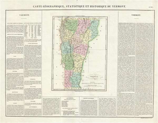

Title
Carte Géographique, Statistique et Historique du Vermont.
1825 (dated) 18.5 x 24.5 in (46.99 x 62.23 cm) 1 : 900000
1825 (dated) 18.5 x 24.5 in (46.99 x 62.23 cm) 1 : 900000
Description
FOR THE ORIGINAL ANTIQUE MAP, WITH HISTORICAL ANALYSIS, CLICK HERE.
Digital Map Information
Geographicus maintains an archive of high-resolution rare map scans. We scan our maps at 300 DPI or higher, with newer images being 600 DPI, (either TIFF or JPEG, depending on when the scan was done) which is most cases in suitable for enlargement and printing.
Delivery
Once you purchase our digital scan service, you will receive a download link via email - usually within seconds. Digital orders are delivered as ZIP files, an industry standard file compression protocol that any computer should be able to unpack. Some of our files are very large, and can take some time to download. Most files are saved into your computer's 'Downloads' folder. All delivery is electronic. No physical product is shipped.
Credit and Scope of Use
You can use your digial image any way you want! Our digital images are unrestricted by copyright and can be used, modified, and published freely. The textual description that accompanies the original antique map is not included in the sale of digital images and remains protected by copyright. That said, we put significant care and effort into scanning and editing these maps, and we’d appreciate a credit when possible. Should you wish to credit us, please use the following credit line:
Courtesy of Geographicus Rare Antique Maps (https://www.geographicus.com).
How Large Can I Print?
In general, at 300 DPI, you should at least be able to double the size of the actual image, more so with our 600 DPI images. So, if the original was 10 x 12 inches, you can print at 20 x 24 inches, without quality loss. If your display requirements can accommodate some loss in image quality, you can make it even larger. That being said, no quality of scan will allow you to blow up at 10 x 12 inch map to wall size without significant quality loss. For more information, it is best consult a printer or reprographics specialist.
Refunds
If the high resolution image you ordered is unavailable, we will fully refund your purchase. Otherwise, digital images scans are a service, not a tangible product, and cannot be returned or refunded once the download link is used.
Cartographer
Jean Alexandre Buchon (May 21, 1791 - August 29, 1849) was a French scholar, historian, and politician. Born at Menetou-Salon, he followed his family to Paris in 1813 as his father had to flee the region. Finally, his father fled to California. This left Buchon the sole provider for his six brothers and sisters. A prolific publisher, he translated numerous works from English to French and also several of his own works. An ardent liberal, he took an active role during the Restoration and was named Inspector of Archives and Libraries in 1828. Thrown out of office in 1829 due to his political opinions, he returned to government life in 1840-41 when he was charged with a diplomatic mission to Greece. During the intervening years, Buchon published most of his writings. Buchon's most important contribution to geography was the publication of the French edition of Carey and Lea's American Atlas in 1825. A highly detailed text about the state or territory depicted and a map of the area were featured on each page of the atlas. The French edition of this atlas is generally considered to be of high quality when compared with other editions, as it has quality paper and superior engraving. More by this mapmaker...
References
Rumsey 0102.015. OCLC 431762971.