This item has been sold, but you can get on the Waitlist to be notified if another example becomes available, or purchase a digital scan.
1854 Logerot City Map or Plan of Versailles, France
Versailles-logerot-1854$187.50

Title
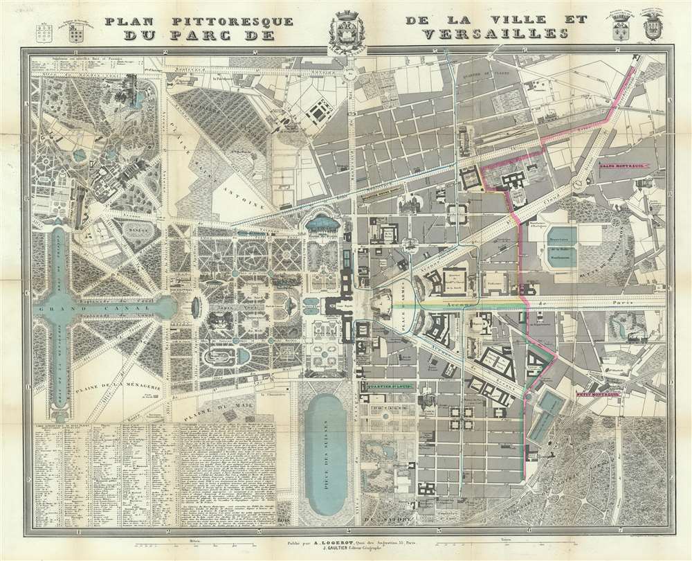
Plan Pittoresque de la Ville et du Parc du Versailles.
1854 (undated) 16 x 20 in (40.64 x 50.8 cm) 1 : 5000
1854 (undated) 16 x 20 in (40.64 x 50.8 cm) 1 : 5000
Description
This is an 1854 Auguste Logerot city map of plan of Versailles, France. The map depicts the region from the Grand Trianon to the Butte de Montbauron and from the Boulevard St. Antoine to the Bois de Satory. Highly detailed, myriad locations throughout are labeled. The Gardens of Versailles are illustrated in detail and identifies the paths, pools, and fountains, as well as the Grand and Petit Trianon. Parts of the palace are also labeled, although in not as much detail. Both the Senate and the National Museum are identified as occupying parts of the chateau itself. Outside the Domain of Versailles, the city is also shown in some detail, labeling numerous buildings, including the prefecture, the city hall, the hospital, and the market. The view of Versailles from the Place d'Armes is illustrated in profile, as is the Church of Notre-Dame and the train station that greets visitors from Paris. An index of locations throughout the map is situated in the lower left corner and lists streets, boulevards, and squares, among others.
Census and Publication History
This map was published by Auguste Logerot and J. Gaultier in 1854. Examples of this map are included in the collections of the Bibliotheque Nationale de France, Stanford University, and the Biliotheque intervuniversitaires Sainte-Genevieve in Paris. It is rare on the private market, making this a charming addition to any Francophile's collection, particularly with its wonderfully detailed depiction of the Gardens of Versailles.Cartographer
Auguste Logerot (fl. c. 1839 - c. 1880) was a French map and general interest publisher active throughout the mid to late 19th century. A. Logerot worked with other French publishers, cartographers and engravers of the period including Fremin, Dufour, Dyonnet, and Vuillemin. He published a large corpus of map and geographical atlases, though few of his map represented unique or exceptionally interesting work. This exception are his wonderful jigsaw puzzle maps - a style popular in 19th century France. Jigsaw puzzle maps are a kind of educational map printed on board and carved up in puzzle format. Logerot's imprint is frequently misprinted as Lagerot or Logeret. Logerot shared offices with several other publishers, printers and engravers at Quai des Augustins 55, Paris. Little else is known of Logerot's life and work. More by this mapmaker...
Condition
Good. Backed on archival tissue for stability. Light toning along original fold lines. Blank on verso.
References
BNF GE C-6913 (A). OCLC 494897739.