1943 Army Orientation Course Newsmap Map of the Pacific Ocean and Asia
Vol2No32-newsmap-1943$275.00


Title
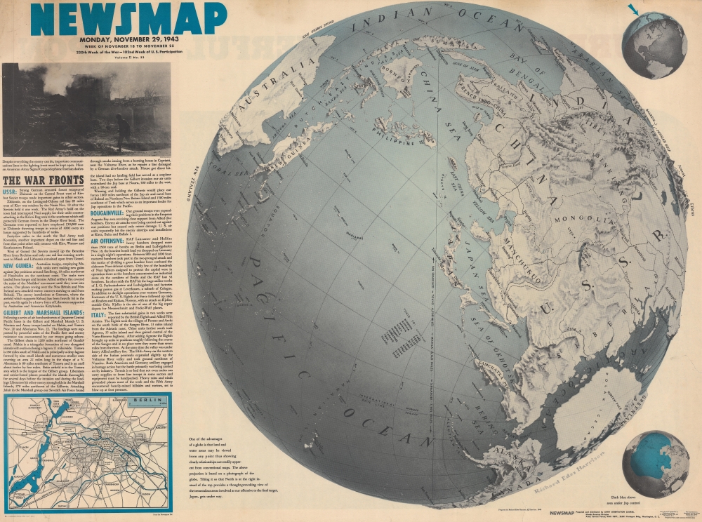
NEWSMAP. Monday, November 29, 1943. Week of November 18 to November 25. 220th Week of the War - 102nd Week of U.S. Participation.
1943 (dated) 34.5 x 46.5 in (87.63 x 118.11 cm)
1943 (dated) 34.5 x 46.5 in (87.63 x 118.11 cm)
Description
Attempting to help viewers gain a new perspective on distances involved in fighting the Pacific front, this is a 1943 Army Orientation Branch Newsmap map of the Pacific Ocean and Asia. Using a map created by Richard Edes Harrison, this Newsmap places Japan at the center of a globe.
A Closer Look
Dominating nearly all the sheet, the map created by Richard Edes Harrison depicts part of the Earth from the Indian Ocean to the west coast of the United States. Japan appears near center, with the rest of the depicted area curving away from there. Nearly all of Asia is illustrated. Moscow, the Caspian Sea, the Persian Gulf, and Arabia appear on one horizon and Samoa and New Zealand are illustrated on the other. A caption below and to the left provides insightOne of the advantages of a globe is that land and water areas may be viewed from any point thus showing clearly relationships not readily apparent from conventional maps. The above projection is based on a photograph of the globe. Tilting it so that North is at the right instead of the top provides a thought-provoking view of the tremendous areas involved as our offensive to the final target, Japan, gets under way.Harrison's maps always provide viewers with a different perspective than is prevalent, allowing them to understand the world in a different way. In this instance, by tilting the globe and putting Japan at the center, one realizes just how close and yet how far so many parts of the world are. Harrison reinforces this reality by including data concerning distances between San Francisco and Tokyo, Manila, and Singapore. Distances from Tokyo to important battlefields in the Pacific, such as Midway, Kiska, and Truk (all place names readers in the 1940s likely would have heard before) are included as well. To the right of the globe, two smaller globes highlight the area depicted by the large map and the area controlled by the Japanese.
The War Fronts
Six short paragraphs to the left of the map provide soldiers deployed around the world with updates on the fighting in other theaters. These include gains on the Eastern Front in Europe by both the Germans and the Red Army, landings in the Gilbert and Marshall Islands (Makin and Tarawa), Allied gains in Italy, and continued raids and their resulting losses in the Air War over Europe. A photo above the text captures a moment in Italy after a German dive bomber attack and below the text a map details Berlin.Publication History and Census
This map was created by Richard Edes Harrison for TIME Magazine in 1940 and repurposed by the Army Orientation Branch for publication as part of a Newsmap in November 1943. We note five examples cataloged in OCLC which are part of the collections at the Boston Athenaeum, Pennsylvania State University, Denison University, the University of Missouri Columbia, and the Denver Public Library. An example is also part of the collection at the University of North Texas.CartographerS
The Army Orientation Branch (1940 - c. 1949) created special maps for teaching the Army Orientation Course and was based at The Pentagon in Washington, D.C. The Army Orientation Branch was part of the Information and Education Division. More by this mapmaker...
Richard Edes Harrison (1902 - January 5, 1994) was an American cartographer and cartoonist active in the middle part of the 20th century. Harrison is credited with redefining cartography, especially journalistic cartography, by employing spherical perspective, bold shading, and graphic design to both make maps more publicly accessible and give them an artistic dimension. Harrison was born in Baltimore and studied design at Yale, graduating in 1923, before relocating to New York City at the height of the Great Depression. He made ends meet through industrial design work, creating everything from bottles to ashtrays. His first foray into the cartographic world was a fill-in job at Fortune magazine. The editors at Fortune must have admired his work for it launched a long-standing collaboration. His work, doubtless inspired by the age of air travel, became exceptionally popular during World War II, where his unique approach and political charged subject matter illustrated the seats of war with exceptional poignancy and clarity. After the war, Harrison continued to produce maps from his base in New York City. In his spare time he was an avid ornithologist and was commonly seen in Central Park in search of rare bird sightings. Learn More...
Condition
Good. Some edge wear. Light creasing. Closed tears extending 2.5, 3, and 4.5 inches into printed area professionally repaired on verso. Text concerning military secrecy on verso.
References
OCLC 62558330. University of North Texas W 109.207:2/32.