1753 Jonas Hanway Map of the Volga River, Russia
Volga-gibson-1753$250.00
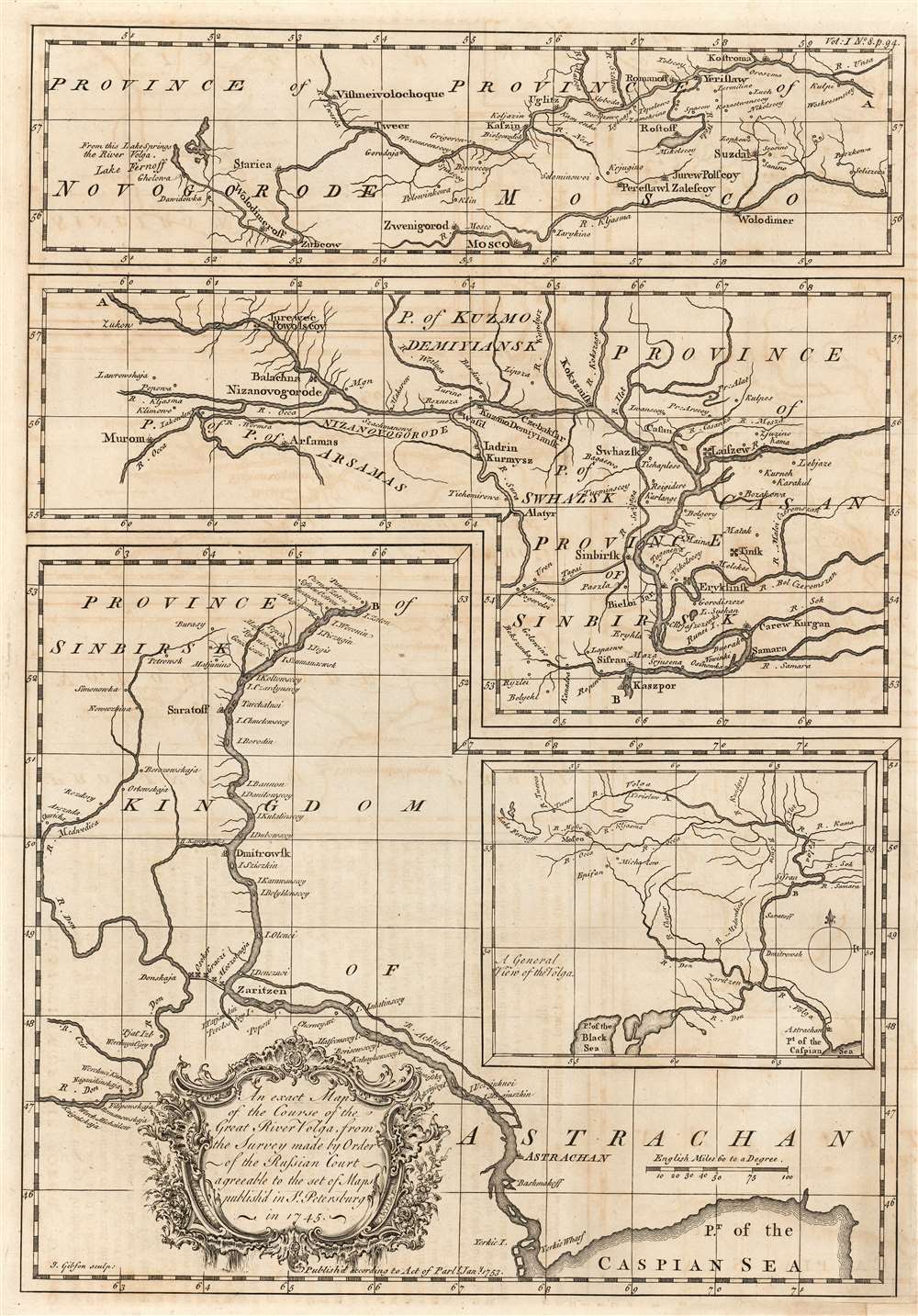

Title
An exact map of the course of the Great River Volga, from the Survey made by Order of the Russian Court agreeable to the set of Maps publish'd in St. Petersburg in 1745.
1753 (dated) 15 x 10.5 in (38.1 x 26.67 cm) 1 : 3800000
1753 (dated) 15 x 10.5 in (38.1 x 26.67 cm) 1 : 3800000
Description
This is a superbly detailed chart of the Volga River, engraved by John Gibson in 1753, produced for inclusion in Jonas Hanway's An Historical Account of the British Trade Over the Caspian Sea. It relies on details provided Hanway by sources in the Russian Academy in St. Petersburg. In composing the map, Gibson has solved the problem of displaying a long, meandering river in detail by framing the map in three sections, adding a fourth general map to indicate how the detail maps connect. A General View of the Volga, positioned in the lower right quadrant of the sheet, shows the full length of the Volga from its source to the Caspian Sea with the letters 'A' and 'B' marking the points where the corresponding positions on the detail maps connect.
Joining the Don and Volga Rivers
One fascinating detail is the clear depiction of the Don-Volga Portage and its forts, pictured connecting the River Don and the River Volga at those rivers' nearest navigable point near Tsaritsyn (Volgograd / Stalingrad). The significance of this route extends through history: settlements along the Don-Volga Portage go back more than 2400 years. The Ottoman Empire may have attempted a canal there as early as the sixteenth century, although that project was abandoned. Eventually the region fell within the borders of the expanding Russian Empire, and Peter the Great made efforts to connecting the two rivers. Abortive attempts at canalizing the portage began as early as 1696 following the Russian capture of Azov, but were abandoned following the 1711 return of that fortress to the Ottomans. Railways were be built along the Portage in the 19th century but a modern canal linking the Don and the Volga was not be completed until 1952. Peter the Great's attempt to connect the upper Don and Volga far upriver at Yepifan were impractical due to the shallowness of the rivers. (The city, spelled Epifan, appears at the uppermost reach of the Don on the 'general' inset but is too remote to be included in any of the main maps.) The Petrov Val canal between the Don and Volga tributaries Ilovlya and Kamyshinka, operated with some success from 1702 until its abandonment in 1709. It is shown here (as the Kamyshinka River) emptying into the Volga near Dmitrowsk (Kamyshin).Publication History and Census
The chart was engraved by John Gibson in 1753 for inclusion in Jonas Hanway's An Historical Account of the British Trade over the Caspian Sea. We are aware of three editions of the work, this example appeared in the third. We see eight examples of the complete work in institutional collections. We see only one example of this map catalogued in OCLC, at the National Library of Scotland.CartographerS
Jonas Hanway (August 12, 1712 - September 5, 1786), was an English philanthropist, traveller, and writer. He was apprenticed in 1729 to a merchant in Lisbon, but in 1743 he became partner to merchant and member of the British Russia Company Robert Dingley (1710 - 1780) who was based in St. Petersburg. This led to the travels in Russia, Central Asia, and Persia which would inform Hanway's (copious) writing on the topic of British trade in the Caspian Sea, which would earn him the attentions of scholar Charles Wilson who hailed him 'one of the most indefatigable and splendid bores of English history.' On his return to London his narrative brought him some fame and success, and thereafter he remained in the city devoted to good causes and good citizenship. He founded The Marine Society in 1756 (a charity supporting inland youths wishing to go to sea.) He was instrumental in the aid of various hospitals; arranged improvements in Londons's birth registration system; and in 1762 he was appointed a commissioner for victualling the navy. Hanway was an eccentric and a gadfly. He protested, voluminously, the English practice of tea drinking, both on the grounds of its effect on the health and on the balance of foreign trade. He was the first male Londoner to carry an umbrella. This shocking move drew the opprobrium of fellow Londoners who objected to the effeminate, French contraption, and the ire of hansom cab drivers who quite correctly identified the invention as a threat to their trade (rainstorms caused Londoners to flock to hansom cabs as a sheltered means of transport.) He died unmarried. A monument to his memory stands in Westminster Abbey, praising his works of charity. It discusses neither umbrellas nor tea. More by this mapmaker...
John Gibson (1724 – 1773) was an English map engraver active in London at the end of the 18th century. Gibson was the son of a locksmith. In 1739 he apprenticed to John Blundell as a stationer of Grub Street. Gibson proved a fine engraver and was much in demand by London map publishers. During his career he produced thousands of maps and was admired as a skilled engraver and sculptor. Among others, he engraved for Emanuel Bowen, Robert Sayer, Jean Palairet, John Rocque, Andrew Dury, and Benjamin Martin. His best known work was prepared in conjunction with Gentleman's Magazine. Gibson, sadly, was not as astute in his fiscal affairs as with the engravers pen and consequently spent much of his life consigned to debtor's prison. Learn More...
Source
Hanway, Jonas, An Historical Account of the British Trade over the Caspian Sea with the Author's Journal of Travels from England through Russia into Persia; and back through Russia, Germany and Holland, (London) 3rd Edition, 1762.
Condition
Very good. Margin reinstated at lower right corner with no impact on image. Faint offsetting, else very bright and sharp.
References
OCLC 316563998.