1878 Hayden Geologic Map of Grand Teton, Jackson Hole and Environs
WWyomingSEIdaho-hayden-1878-2$500.00


Title
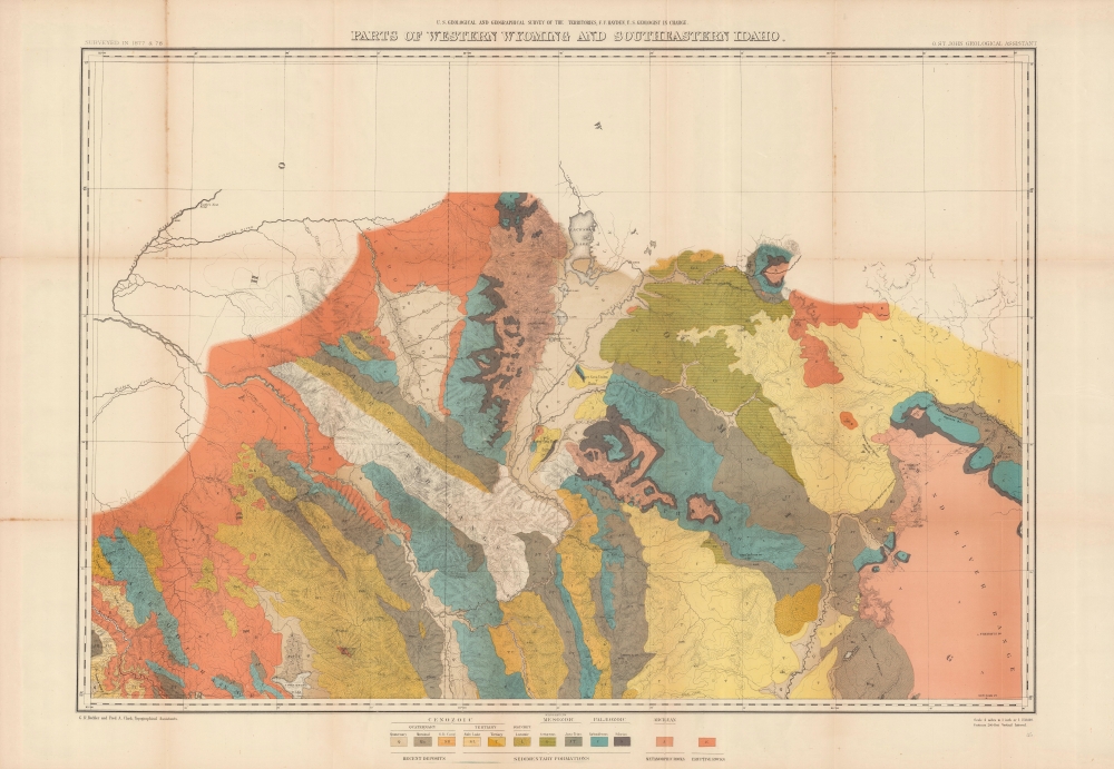
Parts of western Wyoming and southeastern Idaho.
1878 (dated) 25.75 x 34.75 in (65.405 x 88.265 cm) 1 : 253440
1878 (dated) 25.75 x 34.75 in (65.405 x 88.265 cm) 1 : 253440
Description
A brightly colored, large-format map of Grand Teton and surrounding mountains produced in 1878 by the U.S. Geological and Geographical Survey of the Territories, forerunner to the U.S. Geological Survey. It is among the earliest mappings of this region, and certainly was the most comprehensive at the time of publication.
Due to these complexities, the map appears in multiple listings in the OCLC. All told, it is cataloged among the holdings of some thirty institutions worldwide, while the entire 1878 Annual Report is somewhat more widely distributed.
A Closer Look
Taking in the Teton, Gros Ventre, and Snake River, along with portions of the Blackfoot and Wind River Ranges, this map carefully notes topography (represented with contours) along with rivers, creeks, lakes, hot springs, river fords, and mountain passes. Rocks of different geologic eras are highlighted using brilliant colors according to the system explained at bottom. The Snake River cuts prominently across the map. Mountain peaks are noted with their elevation. A small triangle near the confluence of the Snake and Gros Ventre Rivers may denote a camp site for the topographers. The valleys of Pierre's Hole and Jackson's Hole (Jackson Hole) on either side of Grand Teton are mapped for the first time in significant detail.The U.S. Geological and Geographical Survey of the Territories
The U.S. Geological and Geographical Survey of the Territories (also known as the Hayden Survey) was created under the U.S. Department of the Interior in 1870, with Hayden as its director. It operated through 1879. The first year the Survey operated in Wyoming on a budget of $25,000 with twelve assistants and eight teamsters and cooks. The following year (1871), the Survey received $40,000 and employed thirty-two individuals, including artist Thomas Moran and photographer W. H. Jackson. That year they launched from Ogden, Utah (which the Union Pacific Railroad had reached) and spent the summer in what is now Yellowstone National Park. The work conducted by the survey that year played a critical role in convincing the U.S. Senate to create Yellowstone, the first U.S. National Park. The Survey worked in Colorado from 1873 through 1876 because of hostilities between white settlers and Native Americans in Wyoming. The team returned to the Yellowstone in 1877 and 1878. Then, in 1879, the Hayden Survey, along with surveys led by John Wesley Powell (the Colorado River and the Grand Canyon) and Clarence King (Fortieth Parallel Survey), were merged to create the U.S. Geological Survey.Publication History and Census
This map was produced by the USGGST, led by Ferdinand Vandeveer Hayden, and credits Gustavus R. Bechler and Fred A. Clark as geological assistants. Though it notes that the surveying had been undertaken in 1877 and 1878, it in fact drew heavily on surveys conducted in 1872 by James Stevenson, also of the USGGST. This map appeared in the Twelfth Annual Report of the USGGST for the year 1878 (the map is also sometimes dated to 1883 as the 1878 report was not published by the Government Printing Office until 1883). There are two printings of this map, one black-and-white without the chromolithographed geological strata, and the present, colored example. Neither should be confused with the similarly titled map 'Parts of Western Wyoming, Southeastern Idaho and Northeastern Utah,' also published in the 1878 report.Due to these complexities, the map appears in multiple listings in the OCLC. All told, it is cataloged among the holdings of some thirty institutions worldwide, while the entire 1878 Annual Report is somewhat more widely distributed.
CartographerS
Ferdinand Vandeveer Hayden (September 7, 1829 - December 22, 1887) was an American geologist remembered for leading late 19th century pioneering surveying expedition in the Rocky Mountains and served as a doctor in the Union Army during the U.S. Civil War. Born in Westfield, Massachusetts, and discovered a fascination with nature and wildlife in his youth. He studied at Oberlin College and graduated in 1850, then attended the Albany Medical College and earned his degree in 1853. While at Albany, Hayden garnered the attention of Professor James Hall, then the state geologist of New York. Professor Hall convinced Hayden to join an expedition to the Nebraska Territory, where he collected fossils and studied geology. He accompanied expeditions led by Gouverneur K. Warren in 1856 and 1857 and the Raynolds Expedition of 1860 led by Captain William F. Raynolds. He served as an army surgeon during the U.S. Civil War and rose to become the chief medical officer of the Army of the Shenandoah. After the war, Hayden resumed working on geologic and geographic surveys in the Nebraska and Western Territories and was appointed geologist-in-chief of the United States Geological and Geographical Survey of the Territories in 1867. Hayden led the first federally funded geological survey into the Yellowstone Region in northwestern Wyoming in 1871 under orders from Secretary of the Interior Columbus Delano. The expedition included fifty men, including painter Thomas Moran and Civil War photographer William Henry Jackson. Hayden's report on the expedition, Preliminary Report of the United State Geological Survey of Montana and Portions of Adjacent Territories; Being a Fifth Annual Report of Progress played an instrumental role in persuading Congress to establish Yellowstone as the first U.S. National Park. More by this mapmaker...
Gustavus R. Bechler (fl. c. 1856 - 1878) was a surveyor and cartographer best known for his work with the U.S. Geological and Geographical Survey of the Territories (USGGST), led by Ferdinand Vandeveer Hayden. He appears to have gotten his start producing maps of counties in Pennsylvania, New York, and Michigan. During the U.S. Civil War, he drew several impressive, large-scale maps of highlighting battles and campaigns. Virtually nothing is known of Bechler's biographical details, despite being one of the more prolific members of USGGST, acting as chief topographer on Hayden's expedition to Yellowstone. The scant notes referring to him by other members of the survey suggest that he was skilled but difficult to work with. The Bechler River in Yellowstone National Park is named for him. Learn More...
Julius (Julien) Bien (September 27, 1826 - December 21, 1909) was a German-Jewish lithographer and engraver based in New York City. Bien was born in Naumburg, Germany. He was educated at the Academy of Fine Arts, Cassell and at Städel's Institute, Frankfurt-am-Main. Following the suppression of the anti-autocratic German Revolutions of 1848, Bien, who participated in the pan-German movement, found himself out of favor in his home country and joined the mass German immigration to the United States. Bien can be found in New York as early as 1849. He established the New York Lithographing, Engraving & Printing Company in New York that focused on the emergent chromo-lithograph process - a method of printing color using lithographic plates. His work drew the attention of the U.S. Government Printing Office which contracted him to produce countless government maps and surveys, including the Pacific Railroad Surveys, the census, numerous coast surveys, and various maps relating to the American Civil War. Bien also issued several atlases both privately and in conjunction with a relation, Joseph Bien. At the height of his career Bien was elected president of the American Lithographers Association. After his death in 1909, Bien's firm was taken over by his son who promptly ran it into insolvency. The firm was sold to Sheldon Franklin, who, as part of the deal, retained the right to publish under the Julius Bien imprint. In addition to his work as a printer, Bien was active in the New York German Jewish community. He was director of the New York Hebrew Technical Institute, the New York Hebrew Orphan Asylum, and president of the B'nai B'rith Order. Learn More...
Source
Hayden, F. V., Twelfth Annual Report of the United States Geological and Geographical Survey of the Territories: A report of progress of the exploration in Wyoming and Idaho for the year 1878, (Washington, D.C.: Government Printing Office) 1883.
Condition
Good. Creasing and toning along fold lines.
References
Rumsey 5944.000. OCLC 31091683.