Digital Image: 1945 Van Zelm Original Manuscript Political Cartoon of War Coming for Japan
WarDoesNotPay-vanzelm-1945_d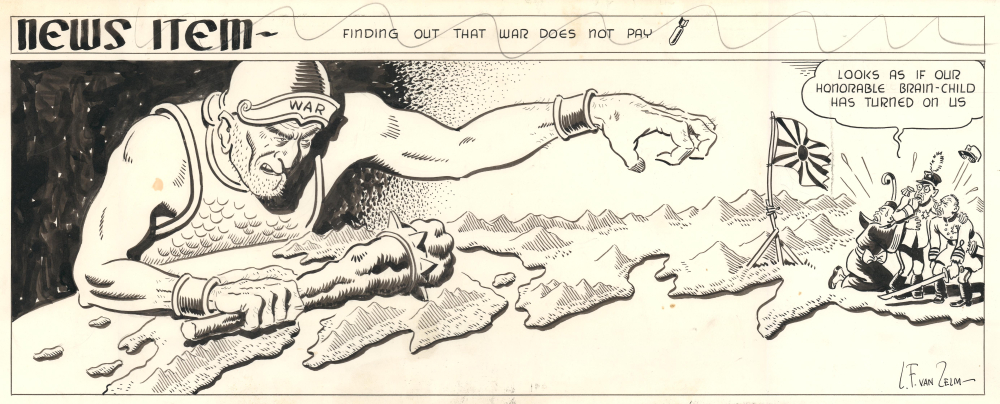


Title
Finding Out War Does Not Pay.
1945 (dated) 7.25 x 18.25 in (18.415 x 46.355 cm)
1945 (dated) 7.25 x 18.25 in (18.415 x 46.355 cm)
Description
FOR THE ORIGINAL ANTIQUE MAP, WITH HISTORICAL ANALYSIS, CLICK HERE.
Digital Map Information
Geographicus maintains an archive of high-resolution rare map scans. We scan our maps at 300 DPI or higher, with newer images being 600 DPI, (either TIFF or JPEG, depending on when the scan was done) which is most cases in suitable for enlargement and printing.
Delivery
Once you purchase our digital scan service, you will receive a download link via email - usually within seconds. Digital orders are delivered as ZIP files, an industry standard file compression protocol that any computer should be able to unpack. Some of our files are very large, and can take some time to download. Most files are saved into your computer's 'Downloads' folder. All delivery is electronic. No physical product is shipped.
Credit and Scope of Use
You can use your digial image any way you want! Our digital images are unrestricted by copyright and can be used, modified, and published freely. The textual description that accompanies the original antique map is not included in the sale of digital images and remains protected by copyright. That said, we put significant care and effort into scanning and editing these maps, and we’d appreciate a credit when possible. Should you wish to credit us, please use the following credit line:
Courtesy of Geographicus Rare Antique Maps (https://www.geographicus.com).
How Large Can I Print?
In general, at 300 DPI, you should at least be able to double the size of the actual image, more so with our 600 DPI images. So, if the original was 10 x 12 inches, you can print at 20 x 24 inches, without quality loss. If your display requirements can accommodate some loss in image quality, you can make it even larger. That being said, no quality of scan will allow you to blow up at 10 x 12 inch map to wall size without significant quality loss. For more information, it is best consult a printer or reprographics specialist.
Refunds
If the high resolution image you ordered is unavailable, we will fully refund your purchase. Otherwise, digital images scans are a service, not a tangible product, and cannot be returned or refunded once the download link is used.
Cartographer
Louis Franklin van Zelm (December 9, 1895 - March 24, 1961) was an American cartoonist. Born in New Rochelle, New York, Van Zelm graduated from the Massachusetts Institute of Technology in 1918, where he studied architecture. He had been interested in cartooning from a young age and even garnered a reputation as one of the best cartoonists at MIT while he was a student there. During the 1920s, he drew the cartoon series 'Rusty and Bub' and collaborated with J. P. McEvoy on the comic strip 'The Potters'. He also drew the strip 'Such Is Life' during this period. In 1925 an issue of The Technology Review updated fellow MIT alumni and alumnae about Van Zelm's recent career change, 'All the yellow journals through the Middle West in mid-December printed long stories to the effect that L.F. van Zelm, whom we all remember as the best little cartoonist we had during our days at the Institute, has deserted architecture for cartooning, and is now cleaning up hordes of shekels as the perpetrator of a comic strip which makes a daily appearance in the dailies throughout that section. I feel sure all the gang join me in wishing Van the greatest success.' Van Zelm gave up cartooning around the end of the 1920s and went into real estate. However, in 1941, he went back to being a cartoonist and started working for the Christian Science Monitor, where he created the comic strip the 'Van Gnomes' and worked as an editorial cartoonist for 10 years. He left the Christian Science Monitor in 1951 to go freelance, but continued contributing to that magazine off and on for the rest of his career. His last strip, 'Farnsworth', debuted in 1958. Van Zelm married three times, and it appears he never had any children. More by this mapmaker...