This item has been sold, but you can get on the Waitlist to be notified if another example becomes available, or purchase a digital scan.
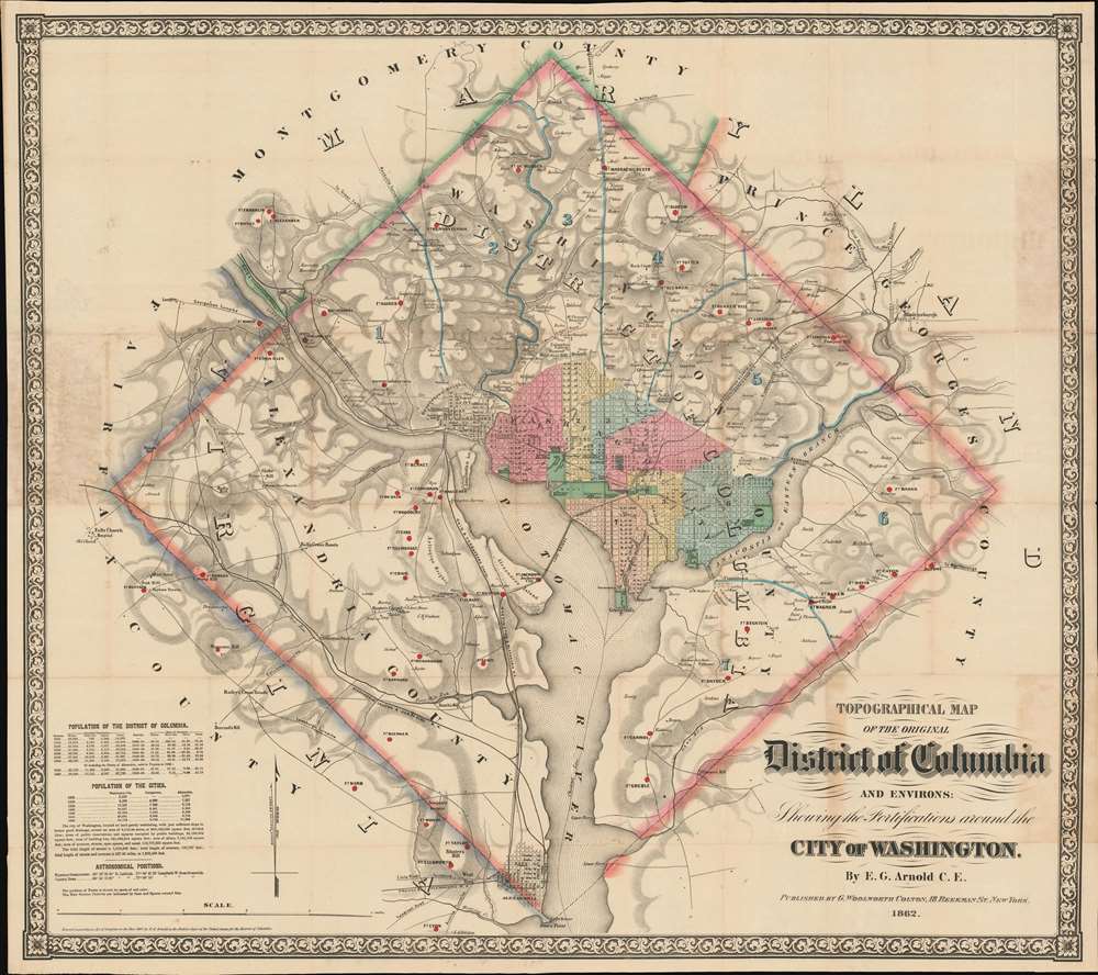
1862 Arnold Map of Washington D.C. during the Civil War
WashingtonDC-arnold-1862$14,750.00


Title
Topographical Map of the Original District of Columbia and Environs: Showing the Fortifications around the City of Washington.
1862 (dated) 30.5 x 34.5 in (77.47 x 87.63 cm) 1 : 31680
1862 (dated) 30.5 x 34.5 in (77.47 x 87.63 cm) 1 : 31680
Description
Known as 'The Arnold Map', this is the most important Civil War era map of Washington D.C. and vicinity. This map was issued by Edward Greene 'Aloha Vivarttas' Arnold and G. W. Colton in 1862, just after the Second Battle of Bull Run. Centered on the White House, the map illustrates the 'original' ten-mile-square diamond-shaped land allocation set aside for the District of Columbia. As a cartographic piece, Arnold's map exceeded in quality all previous maps of the region, noting roads, canals, turnpikes, railroads, and mills, as well offering a meticulous presentation of topography. Significantly, it illustrates the 51 fortifications, army hospitals, and dozens of small batteries - all critical wartime reconnaissance.
Seized and Destroyed
In September of 1862, the map hit the shelves of Washington bookshops and immediately caught the attention of Secretary of War, Edwin Stanton. Reeling from a defeat days earlier at the Second Battle of Bull Run (Aug 29, 1862 - Aug 30, 1862), Stanton recognized the map as a strategic asset should it fall into Confederate hands, and consequently ordered all examples confiscated and destroyed. As noted in the Washington Post, Nov. 6, 1892,…two days after the first copy had been put on sale, the rumor of its existence reached the ears of the War Department, and the officers of the law swooped down on the bookstores and gobbled every copy in stock…. Not only were all the bookstore copies taken, but the name [sic] of those who had bought copies of the map were also learned, and those individuals were promptly called upon and given the alternative of surrendering their purchase or of going to the Old Capitol, which was then the political prison of the city. The plate from which the map had been printed was confiscated as well…Continuing from Civil War Washington: Rare Images from the Albert H. Small Collection (James Goode, Washington History, Vol 15, No. 1, 2003, pp 62-79),The War Department also confiscated the copper plate in New York from which the map was printed. In compensation, Arnold received $8,000 for his loss by the U.S. government.Stanton's censorship of the Arnold Map no doubt accounts for its extreme rarity today.Washington D.C. during the Civil War
Although designated as the national capital, Washington D.C., set on swampy terrain, did not immediately catch on as a place to live or do business. In 1862, when this map was issued, the city hosted only about 60,000 inhabitants (compare to New York at 1,200,000 or Philadelphia at 600,000). When the American Civil War (1861 -1865) broke out, D.C. was at the southernmost limit of Union control, within a day's ride on horseback form the Confederate capital at Richmond. The city promptly became home to thousands of Union troops and support personnel, as well as an ever-growing bureaucracy. It served as a staging area for campaigns in the Potomac Theater as well as the site of numerous field hospitals and relief centers. Just days before this map was issued, the Second Battle of Bull Run (Aug 29, 1862 - Aug 30, 1862), fought just west of Washington, handed Union forces a resounding and devastating defeat.Arnold and His Sources
The author of this map, Edward Greene Arnold, had relocated with his large family to Washington D.C. around 1860, before the war - doubtless hoping to capitalize as architect and civil engineer on the development of the new city. Quoting Goode once again,Arnold reproduced the original 10-mile square laid out by Peter L'Enfant and surveyed by Andrew Ellicott in 1792. Arnold based his map on Boschke's map of 1861, but also included the city of Alexandria, which had been ceded back to Virginia in 1846. The seven wards within D.C. are color coded, and he showed all railroad lines and regional roads entering the city. In a chart at the lower left, Arnold listed the populations of Washington, Georgetown, and Alexandria by decade from 1800 - 1860. He also broke down the population by race into 'white,' 'free colored,' and 'slave.' To Union military authorities, the Arnold Map was important for three reasons: it showed the topography of the area, all the roads leading into the city, and the location of the then 51 forts protecting the city.It is curious that Arnold chose to illustrate the full 1790 ten-mile-square diamond-shaped cession, as Alexandria County (that land west of the Potomac River) was retroceded to Virginia in 1847. It may be that Arnold wanted to claim more Union territory at the expense of Virginia, a Confederate state. It may also be that Arnold, a dedicated Freemason and later a practicing Theosophist, found beauty and harmony in the original diamond-shaped allocation.Publication History and Census
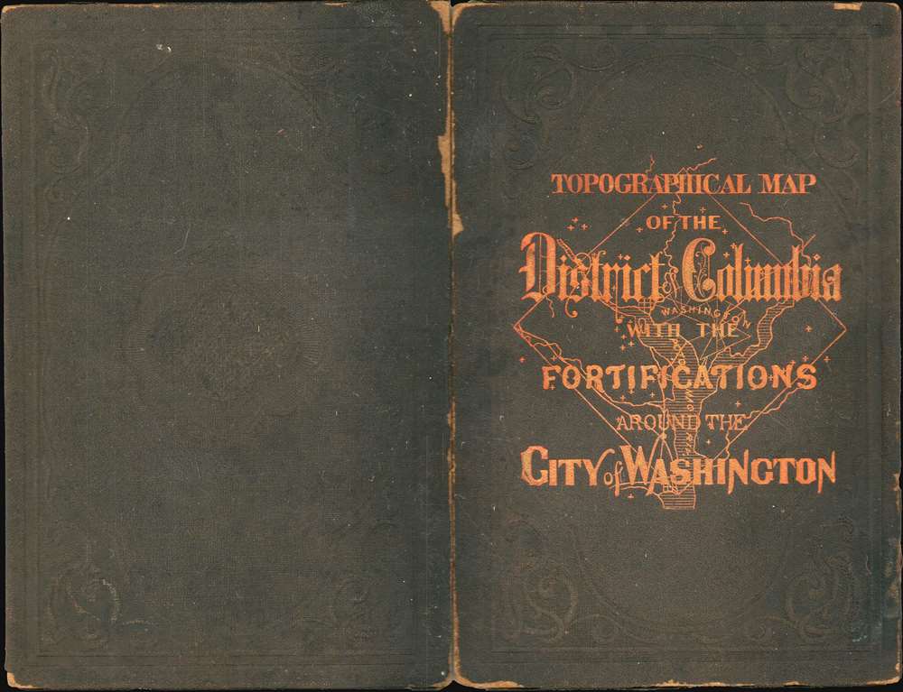
This map drawn by Edward Greene 'Aloha Vivarttas' Arnold and published by George Woolworth Colton (1827 - 1901), elder son of Joseph Hutchins Colton (1800 - 1893). It was issued in September of 1862 and was advertised for sale in Washington D.C. by at least September 10. The copper plate was subsequently destroyed by the War Department and all obtainable examples either confiscated or destroyed. There is, thus, only 1 edition. The map was reproduced in 1902 by Capitol Curio Co. for twenty-sixth annual encampment of the Grand Army of the Republic at Washington. While the 1902 Capitol Curio reproduction does appear on the market from time to time, the original 1862 edition, as here, is for all intent and purposes an otherwise unobtainable map. We have identified just 3 examples sold privately in the last 30 years. Institutional holdings are limited to the Library of Congress, Harvard, and a 60% destroyed example at the New York Public Library.
CartographerS
Edward Greene 'Aloha Vivarttas' Arnold (September 24, 1834 - August 31, 1898) was an American marine architect, civil engineer, and inventor active in Washington D.C. and New York in the middle part of the 19th century. Arnold was born in Providence, Rhode Island, the son of Aza Arnold (1788 - 1865) and Abigail Dennis (1794 - 1877). His family was old and prestigious, having come to the United States in 1663 and settling in East Greenwich, Rhode Island. He studied architecture and engineering. Sometime in the late 1850s, the entire Arnold family, including Asa, moved to Washington D.C. to participate in the building of the new capital. In 1860, he is recorded in both the New York and the Washington D.C. Federal Censuses. In 1861 he produced, in partnership with the Colton firm, an important map of Washington D.C. After the Civil War he relocated to New York City, where he lived until 1880, when he moved to Hoboken. In New York, he successfully established himself as an architect and inventor, filing multiple patents. Sometime after the Civil War, likely in the late 1870s, Edward bizarrely changed his name to 'Aloha Vivarttas', with his wife and children also adopting the 'Vivarttas' name. Vivartta is a Hindu term from Vedic tradition meaning the 'essential material of a thing.' The unusual choice suggests that the Arnold family was associated with the Theosophical Society, a quasi-religious esoteric order rooted in mysticism tenuously connected to Hindu and Buddhist scripture. The Theosophical Society was established in New York in 1874 gaining an immediate following - roughly aligning with the name change. From this point on, 'Aloha Vivarttas' is the given name for census records and other official documentation, such as patent applications, of which he had many. He also named his children 'Vivarttas', abandoning 'Arnold' altogether. Arnold / Viarttas died in Weehawken. His son Percie A. Vivarttas (Arnold), was also a prominent architect. More by this mapmaker...
Joseph Hutchins Colton (July 5, 1800 - July 29, 1893), often publishing as J. H. Colton, was an important American map and atlas publisher active from 1833 to 1897. Colton's firm arose from humble beginnings when he moved to New York in 1831 and befriended the established engraver, Samuel Stiles. He worked under Stiles as the 'Co.' in Stiles and Co. from 1833 to 1836. Colton quickly recognized an emerging market in railroad maps and immigrant guides. Not a cartographer or engraver himself, Colton's initial business practice mostly involved purchasing the copyrights of other cartographers, most notably David H. Burr, and reissuing them with updated engraving and border work. His first maps, produced in 1833, were based on earlier Burr maps and depicted New York State and New York City. Between 1833 and 1855, Colton proceeded to publish a large corpus of guidebooks and railroad maps, which proved popular. In the early 1850s, Colton brought his two sons, George Woolworth Colton (1827 - 1901) and Charles B. Colton (1832 - 1916), into the map business. G. W. Colton, trained as a cartographer and engraver, was particularly inspired by the idea of creating a large and detailed world atlas to compete with established European firms for the U.S. market. In 1855, G.W. Colton issued volume one of the impressive two-volume Colton's Atlas of the World. Volume two followed a year later. Possibly because of the expense of purchasing a two-volume atlas set, the sales of the Atlas of the World did not meet Colton's expectations, and so, in 1856, the firm also issued the atlas as a single volume. The maps contained in this superb work were all original engravings, and most bear an 1855 copyright. All of the maps were surrounded by an attractive spiral motif border that would become a hallmark of Colton's atlas maps well into the 1880s. In 1857, the slightly smaller Colton's General Atlas replaced the Atlas of the World. Most early editions of the General Atlas published from 1857 to 1859 do not have the trademark Colton spiral border, which was removed to allow the maps to fit into a smaller format volume. Their customers must have missed the border because it was reinstated in 1860 and remained in all subsequent publications of the atlas. There were also darker times ahead; in 1858, Colton was commissioned at a sum of 25,000 USD by the government of Bolivia to produce and deliver 10,000 copies of a large format map of that country. Although Colton completed the contract in good faith, delivering the maps at his own expense, he was never paid by Bolivia, which was at the time in the midst of a series of national revolutions. Colton would spend the remainder of his days fighting with the Bolivian and Peruvian governments over this payment, and in the end, after a congressional intervention, he received as much as 100,000 USD in compensation. Nonetheless, at the time, it was a disastrous blow. J. H. Colton and Company is listed as one of New York's failed companies in the postal record of 1859. This led Colton into the arms of Alvin Jewett Johnson and Ross C. Browning. The 1859 edition of Colton's General Atlas lists Johnson and Browning as the 'Successor's to J. H. Colton' suggesting an outright buyout, but given that both companies continued to publish separately, the reality is likely more complex. Whatever the case may have been, this arrangement gave Johnson and Browning access to many of Colton's map plates and gave birth to Johnson's New Illustrated (Steel Plate) Family Atlas. The Johnson's Atlas was published parallel to Colton's atlases well into the 1880s. The Colton firm itself subsequently published several other atlases including an Atlas of America, the Illustrated Cabinet Atlas, the Octavo Atlas of the Union, and Colton's Quarto Atlas of the World. They also published a large corpus of wall maps, pocket maps, and guides. The last known publications of the Colton firm date to 1897 and include a map and a view, both issued in association with the Merchant's Association of New York. Alice M. Colton married August R. Ohman (May 3, 1859 - April 22, 1934) on January 5, 1897. In 1898, Ohman joined the Colton firm, which continued to publish as Colton, Ohman & Co. until 1901. Learn More...
Condition
Very good. Some verso reinforcement along a few old fold lines, at fold intersections, and where originally attached to binder. Toning on some folds and where originally attached. Removed from but accompanied by original binder.
References
Miller, I., Washington in Maps, pp. 88-89. Phillips (America), p. 266. Stephenson, R. W., Civil War Maps; an Annotated List of Maps and Atlases in Map Collections of the Library of Congress, #674.