1582 Braun and Hogenberg View / Map of Weimar, Germany
Weimar-braunhogenberg-1582$500.00

Title
Winmaria, Fertliss. Thuringiae Urbs Praestantissima Vulgo Weinmar. Johann Wolfius Rector Gymnasii Ratisbonensis F. C.
1582 (undated) 13.5 x 18.5 in (34.29 x 46.99 cm)
1582 (undated) 13.5 x 18.5 in (34.29 x 46.99 cm)
Description
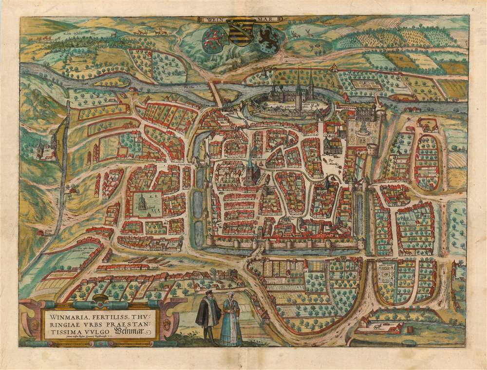
This is a superb original color example of Braun and Hogenberg's city map / view of Weimar. While not the first view of the city published in the Civitates Orbis Terrarum, in 1582 it was the first to command a full sheet. The 1574 edition of the Civitates included a view of the city which shared a sheet with Jena, Erfurt, Gotha, and Fulda. As was the case with many of the views that were similarly clustered, Braun and Hogenberg would later dedicate this full sheet to the plan.
From First-Hand Observation
Braun and Hogenberg, like their contemporary publisher Ortelius, sourced their views and plans as much as possible from scholars who could provide drawings and descriptions from first-hand experience, generally crediting them on the sheet itself or in its associated text. The present work was derived from information provided by Johann Wolf, also known as Wolfius. On the plan, he is credited as 'Rector of the Regensburg Gymnasium' (a secondary school comparable to an English grammar or American preparatory school.) He would later become rector of the gymnasium in Weimar itself, as well as a local mayor. Regensburg and Weimar are separated by 266 kilometers, a nontrivial distance in the 16th century, so it is tempting to speculate that Wolfius' associations with Weimar somehow predate his becoming rector in Regensburg and that his later positions represented a return to a town with which he was clearly familiar.Weimar's Architecture Displayed
The plan is oriented to the east, placing the walled and moat-surrounded city amongst rolling fields and meadows on the west bank of the River Ilm. Although the plan is not presented as a perspective view, the buildings are shown in partial profile, thus giving the impression of a bird's eye view of the city - as well as showcasing some of the city's architectural treasures. On the river at the upper center of the image is the Ducal seat, Hornstein Castle (with its own moat and walls). To the south of the castle stands the palace of Duke Johann Wilhelm, of Saxe-Weimar - now the site of the Herzogin Anna Amalia Bibliothek. The structure shown here, amongst its formal gardens is the so-called 'Green Castle,' built between 1562 and 1566 by architect Nikolaus Gromann. The Gothic church of Saints Peter and Paul commands the center of the view - across the street to the north of the church is shown 'Die newe schule,' possibly the same where Wolfius would in time become rector. Other palaces, gardens and towers are named throughout the plan. As is usually the case with Braun and Hogenberg's views, in the foreground a well-dressed couple display the styles of the city, while at the top center the arms of Saxony are displayed with the striped lion of Thuringia and the arms of the Margraviate of Meissen.Publication History and Census
This engraving was first included in the third volume of Braun and Hogenberg's Civitates Orbis Terrarum in 1581 or 1582 and remained in the work until its last print run of 1617. We see ten examples of the separate plan cataloged in institutional collections.CartographerS
Georg Braun (1541 – March 10, 1622) was a German deacon, viewmaker, and typo-geographer based in Cologne. Along with Franz Hogenberg (1535 - 1590), Braun is best known for his publication of the highly influential city atlas Civitates Orbis Terrarum. The six volume work, with some 546 views, was published between 1572 and 1617 and intended a companion to Abraham Ortelius' Theatrum Orbis Terrarum - thus certain obvious stylistic similarities. In compiling the Civitates Braun took on the role of editor while most of the engraving work was completed by Franz Hogenberg. Braun died, as he was born, in Cologne. More by this mapmaker...
Franz Hogenberg (1535 - 1590), often called 'Master Franz,' was a Flemish engraver active in the late 16th century. Hogenberg was born in Mechelen, the son of Nicolas Hogenberg, where he trained under the cartographer H. Terbruggen. He later relocated to Antwerp where he achieved success as an engraver, working with Abraham Ortelius, Hieronymus Cock, and others. In 1568, his name appeared on the list of those banned from the Netherlands by the Duke of Alva, forcing his family to flee to London. There he engraved for Christopher Saxon's Atlas of England and Wales. By 1570 he emigrated to Germany settling in Cologne. In Cologne he married his second wife, Agnes Lomar, with whom he had six children. In 1579 the couple were briefly imprisoned for holding illicit secret religious meetings, but were released in short order. Along with German cleric George Braun (1541 – March 10, 1622), Hogenberg issued the highly influential city atlas Civitates Orbis Terrarum. The six volume work, with some 546 views, was published between 1572 and 1617 and intended a companion to Abraham Ortelius' Thatrum Orbis Terrarum - thus certain obvious stylistic similarities. In compiling the Civitates Hogenberg took on the role of engraver while most of the editing was left to Georg Braun. Hogenberg died in Cologne, Germany, before the Civitates was completed. After his death, Hogenberg's work was continued by his son, Abraham Hogenberg, who, under the direction of Agnes, his mother, took over his father's enterprise at just 20. Learn More...
Johann Wolf or Wolfius (1524 - 1602) was a German school rector - first in Regensburg, and later rector of the grammar school in Weimar and local mayor. He was the father of Michael Wolf, a mathematician, physicist, logician and metaphysicist. His sole cartographic output appears to have been the town plan of Weimar drawn for Braun and Hogenberg's Civitates Orbis Terrarum, which appeared in that work in 1582. Learn More...
Source
Braun, G. and Hogenberg, F., Civitates Orbis Terrarum, (Antwerp) 1582.
The Civitatus Orbis Terrarum is an 6-volume atlas of cities, or town book, compiled and written by George Braun, Canon of Cologne Cathedral and Franz Hogenberg. Braun and Hogenberg gathered together vast amounts of information and draft plans to produce over 500 city views/maps published in six parts between 1572 and 1617. Most of the town views and plans were engraved by Simon van den Neuvel (Novellanus) and Frans Hogenberg, many after drawings by Joris Hoefnagel. The Civitatus Orbis Terrarum was printed in Cologne, but in the Flemish style after Abraham Ortelius, the preeminent cartographer of the period. The text throughout is the work of Braun. The work proved to be a great success, reflecting the period's greater fascination with notable metropolises than with national boundaries. After the initial publication of volume 1, the popularity of the led to a second volume. In the introduction to volume 2, Braun requests that those who live in cities not represented, sent details of their own metropolises. This led to the publication of volumes 3, 4, and 5. Volume 6, the last, did not appear until 1617 under Franz Hogenberg's son, Abraham Hogenberg. The volumes include
- Civitates orbis terrarium, first edition 1572.
- De praecipuis, totius universi urbibus, liber secundus, first edition 1575.
- Urbium praecipuarum totius mundi, liber tertius, first edition 1581.
- Urbium praecipuarum totius mundi, liber quartus, first edition 1588.
- Urbium praecipuarum mundi theatrum quintum, first edition 1596.
- Theatri praecipuarum totius mundi urbium liber sextus, first edition 1617.
Condition
Very good. Top centerfold reinforced, else excellent with full original color.
References
OCLC 698868629. Van der Krogt, P. C. J., Koeman's Atlantes Neerlandici, 4, 4792. Taschen, Braun and Hogenberg, p.245.