
Hogenberg, Franz

Franz Hogenberg (1535 - 1590), often called 'Master Franz,' was a Flemish engraver active in the late 16th century. Hogenberg was born in Mechelen, the son of Nicolas Hogenberg, where he trained under the cartographer H. Terbruggen. He later relocated to Antwerp where he achieved success as an engraver, working with Abraham Ortelius, Hieronymus Cock, and others. In 1568, his name appeared on the list of those banned from the Netherlands by the Duke of Alva, forcing his family to flee to London. There he engraved for Christopher Saxon's Atlas of England and Wales. By 1570 he emigrated to Germany settling in Cologne. In Cologne he married his second wife, Agnes Lomar, with whom he had six children. In 1579 the couple were briefly imprisoned for holding illicit secret religious meetings, but were released in short order. Along with German cleric George Braun (1541 – March 10, 1622), Hogenberg issued the highly influential city atlas Civitates Orbis Terrarum. The six volume work, with some 546 views, was published between 1572 and 1617 and intended a companion to Abraham Ortelius' Thatrum Orbis Terrarum - thus certain obvious stylistic similarities. In compiling the Civitates Hogenberg took on the role of engraver while most of the editing was left to Georg Braun. Hogenberg died in Cologne, Germany, before the Civitates was completed. After his death, Hogenberg's work was continued by his son, Abraham Hogenberg, who, under the direction of Agnes, his mother, took over his father's enterprise at just 20.
First Atlas Map of the North Parts of the World.
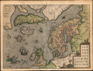
Septentrionalium Regionum Descrip.
$3,000.00
Acquire
- Digital Map Information
- Suitable for large format printing
- Full resolution TIFF file
- ICC color profile embedded
- Delivered instantly via download link
A beautiful example of one of Abraham Ortelius' most interesting maps, his 1570 map of Scandinavia and the Arctic. During the Age of Discovery, the Arctic was as remote and unfamiliar as the coasts of America, Africa, or Asia. This map played a role in propagating several cartographic fallacies, including the Zeno Fraud: Frisland, Estotiland, Drogeo. The present example, in a 1602 Vrients edition, features warm, original color. (more details)
Evocative plan of the medieval city of Weimar.
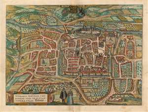
Winmaria, Fertliss. Thuringiae Urbs Praestantissima Vulgo Weinmar. Johann Wolfius Rector Gymnasii Ratisbonensis F. C.
$500.00
Acquire
- Digital Map Information
- Suitable for large format printing
- Full resolution TIFF file
- ICC color profile embedded
- Delivered instantly via download link
This is a superb original color example of Braun and Hogenberg's city map / view of Weimar. While not the first view of the city published in the Civitates Orbis Terrarum, in 1582 it was the first to command a full sheet. The 1574 edition of the Civitates included a view of the city which shared a sheet with Jena, Erfurt, Gotha, and Fulda. As was the case with many of the views that were similarly clustered, Braun and Hogenberg would later dedicate this full sheet to the plan. (more details)
Beautiful Late Medieval Town.
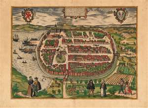
Die Fürstlich Sehestat Barth in Pommern.
$500.00
Acquire
- Digital Map Information
- Suitable for large format printing
- DPI: 600
- File Size: 49.18 MB
- File Type: ZIP / TIFF
- ICC color profile embedded
- Delivered instantly via download link
This is a scarce, beautiful, original color example of Braun and Hogenberg's 1593 bird's-eye view of the city of Barth in Germany, then the capital of the Duchy of Pomerania-Barth. (more details)
Catholic Stronghold of the Netherlands.
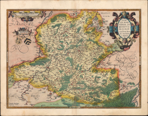
Nobilis Hannoniae Comitatus Descrip.
$275.00
Acquire
- Digital Map Information
- Suitable for large format printing
- Full resolution TIFF file
- ICC color profile embedded
- Delivered instantly via download link
This is a striking old-color example of Abraham Ortelius' 1595 map of the County of Hainaut, the westernmost part of Wallonia in today's Belgium and the eastern part of the present-day French département du Nord. Although exasperated by the tactics employed by the Habsburgs (joining the 1576 Pacification of Ghent, for instance), Hainaut was among the most faithfully Catholic parts of the Netherlands and became a stronghold for the Habsburgs during the Eighty Years' War. (more details)
Stronghold of Lutheranism.
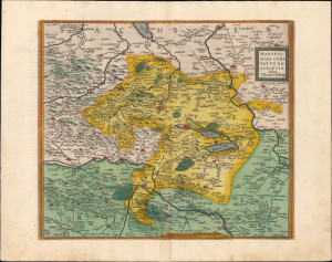
Mansfeldiae Comitatus Descriptio.
$250.00
Acquire
- Digital Map Information
- Suitable for large format printing
- Full resolution TIFF file
- ICC color profile embedded
- Delivered instantly via download link
This is an old-color 1595 map of the town of Mansfeld in central Germany and its environs, published in Abraham Ortelius' Theatrum Orbis Terrarum. It depicts the region after the early decades of the Protestant Reformation and the establishment of Lutheranism, whose founding figure was born and raised here. (more details)
Drawn firsthand by Joris Hoefnagel
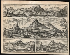
La Penna de los Enamorados. / Archidona. / Penna. / Archidona.
$750.00
Acquire
- Digital Map Information
- Suitable for large format printing
- Full resolution TIFF file
- ICC color profile embedded
- Delivered instantly via download link
These are Joris Hoefnagel's depictions of the Andalusian town of Archidona, and the distinctive peak of La Peña de los Enamorados dominating it, included in the 1596 fifth volume of Georg Braun and Franz Hogenberg's Civitatis Orbis Terrarum, the first published collection of city plans and views. (more details)
Hoefnagel's Eyewitness Views of Venice.
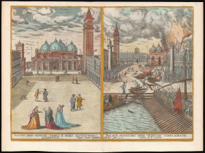
Augusti apud Venetos Templi D. Marci Accuratissima Effiguratio/ Palatii Senatorii Apud Venetos Conflagratio.
$1,100.00
Acquire
- Digital Map Information
- Suitable for large format printing
- Full resolution TIFF file
- ICC color profile embedded
- Delivered instantly via download link
These are Joris Hoefnagel's depictions of Saint Mark's Square in Venice, included in the fifth volume of Georg Braun and Franz Hogenberg's Civitatis Orbis Terrarum, the first published collection of city plans and views. (more details)
Pre-Смутное время plan of Moscow.
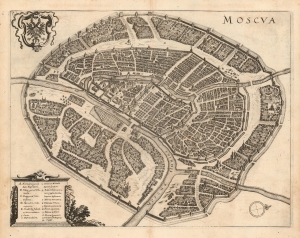
Moscva.
$1,900.00
Acquire
- Digital Map Information
- Suitable for large format printing
- DPI: 600
- File Size: 12.97 MB
- File Type: ZIP / TIFF
- ICC color profile embedded
- Delivered instantly via download link
This is a scarce 1638 Matthais Merian city plan or map of Moscow. Apart from the Braun and Hogenberg, this is the earliest full-sheet edition of the plan, which pre-dates by more than 20 years the version included by Joan Blaeu in his Atlas Maior. (more details)