
This item below is out of stock, but another example (left) is available. To view the available item, click "Details."
Details
1835 Bradford Map of West Indies
1835 (undated) $175.00
1846 Bradford Map of the West Indies
WestIndies-bradford-1846$175.00

Title
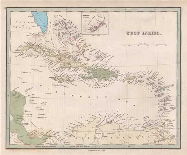
West Indies.
1846 (dated) 12 x 14.75 in (30.48 x 37.465 cm) 1 : 8500000
1846 (dated) 12 x 14.75 in (30.48 x 37.465 cm) 1 : 8500000
Description
This is an 1846 Thomas G. Bradford map of the West Indies. The map depicts the region from the Gulf of Mexico and Honduras to Barbados and the Atlantic Ocean and from Florida and the Bahamas to Colombia and Venezuela. Highly detailed, each island in both the Greater and Lesser Antilles is labeled, along with cities, towns, and villages on nearly all the islands. Coastal locations are labeled on Cuba, Hispaniola, Jamaica, and Puerto Rico. An inset map of Bermuda is situated along the top border.
The Caribbean c. 1846
Slavery was still legal in the Caribbean in at this point in history, just as it was in the United States. In fact, even in 1846, the French were still importing slaves into their Caribbean colonies. Numerous slave uprisings occurred throughout the region, with the last taking place on Cuba only three years prior to the publication of this map, in 1843. Most islands in the Caribbean were still occupied by European colonial powers as well, with Haiti being the first to gain independence from European powers in 1804. Some Caribbean islands are still administered by European countries or the United States, while those that gained independence had to wait until the mid-20th century, or later.
This map was engraved by George Boynton and published in the 1846 edition of Bradford and Goodrich's A Universal Illustrated Atlas.
CartographerS
Thomas Gamaliel Bradford (1802 - 1887) was born in Boston, Massachusetts, where he worked as an assistant editor for the Encyclopedia Americana. Bradford's first major cartographic work was his revision and subsequent republishing of an important French geography by Adrian Balbi, Abrege de Geographie published in America as Atlas Designed to Illustrate the Abridgment of Universal Geography, Modern and Ancient. Afterwards Bradford revised and expanded this work into his own important contributions to American cartography, the 1838 An Illustrated Atlas Geographical, Statistical and Historical of the United States and Adjacent Countries. Bradford's cartographic work is significant as among the first to record Texas as an independent nation. In his long career as a map publisher Bradford worked with William Davis Ticknor of Boston, Freeman Hunt of New York, Charles De Silver of Philadelphia, John Hinton, George Washington Boynton, and others. We have been able to discover little of Bradford's personal life. More by this mapmaker...
George Washington Boynton (fl. c. 1830 - 1850) was a Boston based cartographer and map engraver active in the first half of the 19th century. Boynton engraved and compiled maps for numerous publishers including Thomas Bradford, Nathaniel Dearborn, Daniel Adams, and S. G. Goodrich. His most significant work is most likely his engraving of various maps for Bradford's Illustrated Atlas, Geographical, Statistical, and Historical, of the United States and the Adjacent Countries and Universal Illustrated Atlas. He also engraved for the Boston Almanac. In 1835, Boynton is listed as an employee of the Boston Bewick Company, an engraving, stereotype, and printing concern based at no. 47 Court Street, Boston. Little else is known of his life. Learn More...
Source
Bradford, T. G. and Goodrich, S. G., A Universal Illustrated Atlas, exhibiting a Geographical, Statistical, and Historical view of the World, (Boston: Charles D. Strong) 1846.
The Universal Illustrated Atlas is one of the great American atlases of the first half of the 19th century. The atlas was first published in 1838 under the imprint of Charles D. Strong. It replaced and superseded Bradford's earlier smaller format Illustrated Atlas, Geographical, Statistical, and Historical, of the United States and the Adjacent Countries. Numerous reissues of the Universal Illustrated Atlas followed until about 1848. Although there are minor variations between the editions, most contain about 50 maps, the majority of which focus on the United States. Bradford's atlases are significant for recording North America during the Republic of Texas Era. In later editions, particularly the 1846 edition, Bradford illustrates the boom in railroad construction, possibly with the idea that his maps would aid travelers in planning journeys by rail. It was compiled by Thomas Gamaliel Bradford and Samuel Griswold Goodrich with most of the plates engraved by George Washington Boynton (fl. c. 1830 - 1850). Other contributors include Thomas Gordon (1778 - 1848), Fielding Lucas Jr. (1781 - 1854), Samuel Edward Stiles (1844 - 1901), Sherman and Smith (fl. c. 1829 - 1855), and Horace Thayer (1811 - c. 1874).
Condition
Very good. Even overall toning. Light foxing. Blank on verso.
References
Rumsey 0089.039 (1838 edition).