Digital Image: 1789 Osgood Carleton / John Norman Nautical Map of the West Indies, Florida, Gulf of
WestIndies-norman-1789_d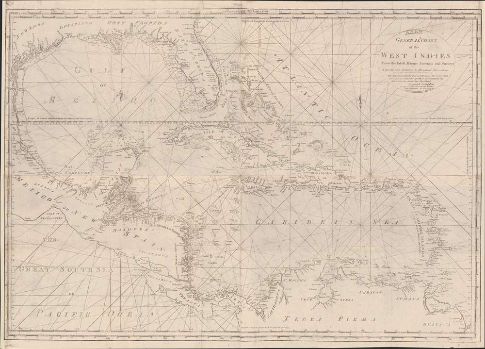

Title
General Chart of the West Indies from the latest Marine Journals and Surveys.
1789 (dated) 28.5 x 39.75 in (72.39 x 100.965 cm) 1 : 4500000
1789 (dated) 28.5 x 39.75 in (72.39 x 100.965 cm) 1 : 4500000
Description
FOR THE ORIGINAL ANTIQUE MAP, WITH HISTORICAL ANALYSIS, CLICK HERE.
Digital Map Information
Geographicus maintains an archive of high-resolution rare map scans. We scan our maps at 300 DPI or higher, with newer images being 600 DPI, (either TIFF or JPEG, depending on when the scan was done) which is most cases in suitable for enlargement and printing.
Delivery
Once you purchase our digital scan service, you will receive a download link via email - usually within seconds. Digital orders are delivered as ZIP files, an industry standard file compression protocol that any computer should be able to unpack. Some of our files are very large, and can take some time to download. Most files are saved into your computer's 'Downloads' folder. All delivery is electronic. No physical product is shipped.
Credit and Scope of Use
You can use your digial image any way you want! Our digital images are unrestricted by copyright and can be used, modified, and published freely. The textual description that accompanies the original antique map is not included in the sale of digital images and remains protected by copyright. That said, we put significant care and effort into scanning and editing these maps, and we’d appreciate a credit when possible. Should you wish to credit us, please use the following credit line:
Courtesy of Geographicus Rare Antique Maps (https://www.geographicus.com).
How Large Can I Print?
In general, at 300 DPI, you should at least be able to double the size of the actual image, more so with our 600 DPI images. So, if the original was 10 x 12 inches, you can print at 20 x 24 inches, without quality loss. If your display requirements can accommodate some loss in image quality, you can make it even larger. That being said, no quality of scan will allow you to blow up at 10 x 12 inch map to wall size without significant quality loss. For more information, it is best consult a printer or reprographics specialist.
Refunds
If the high resolution image you ordered is unavailable, we will fully refund your purchase. Otherwise, digital images scans are a service, not a tangible product, and cannot be returned or refunded once the download link is used.
Cartographer S
John Norman (1748 - June 8, 1817) was an engraver and publisher in Boston, Massachusetts. Born in England, he apprenticed as a printer under the elder William Faden, father of the mapmaker William Faden II (1749 - 1836). Norman completed his apprenticeship in October of 1773 and shortly thereafter moved to Philadelphia. There he established himself as an engraver, publishing his first map The Theatre of War in North America in 1777. He relocated to Boston in 1781. He is best known for nautical charts, many of which represent the earliest American-produced sea charts of the areas depicted, and are consequently among the most important American printed works of the 18th century. Norman had engraved two of the charts for the first American nautical atlas (Mathew Clark’s 1790 A Complete Set of Charts of the Coast of America). The success of this venture inspired Norman to publish is own atlas in 1791, The American Pilot. This is one of the most important American atlases, and loose examples of Norman’s charts are extremely rare on the market. Norman’s work includes portraits, illustrations and architectural diagrams; he also produced maps for publication in works such as Boston Magazine and Malham’s Naval Gazetteer. He died of typhoid in 1817. His son, William Norman (17?? - 1807) began working with him and fully took over publication of the The American Pilot around 1794. More by this mapmaker...
William Norman (17?? - November 18, 1807) was an American stationer, engraver, chart and map publisher active in Boston during the late 18th and early 19th centuries. He was the son and heir of the John Norman (1748 - 1817), one of the first American commercial chart publishers. Norman's imprint first replaces his father's in 1794. He issued editions of American Pilot from 1794 through 1807, when he died suddenly. Learn More...
Osgood Carleton (June 17, 1742 - June 1816) was a Massachusetts-based mapmaker, surveyor, mathematician, philosopher, astronomer, and all-around polymath, active in the late 18th and early 19th centuries. Carleton was born in Nottingham West, New Hampshire, the eldest of 7 children. His father was a farmer and in his early years Carleton had no opportunity for formal education. He joined the colonial militia and participated in the French and Indian War (1754 - 1763). During the war, he became close to the British-Swiss engineer John Henry Bastide (1700 - 1770), under whom from age 15, he served as a clerk for 5 years - likely Carleton's formal education dates to this period. Carleton's own writings suggest he traveled extensively in British circles with Bastide. He later returned to New Hampshire, establishing himself as a surveyor, completing both civil and private contracts. During the American Revolutionary War (1775 - 1783), he joined the Massachusetts Regiment, later the 16th Continental Regiment, where he served as quartermaster with the rank of sergeant. In 1777, He was promoted to lieutenant in the 15th Continental. When his health failed, he was transferred to the Invalid Corps - where he also served as quartermaster until mustered out in 1783. After the war, Carleton settled in Haverhill, Massachusetts. In the wake of the War, education in practical sciences where in high demand and in June of 1787, the Boston Board of Selectmen approved his application to open a school offering lectures in surveying, gauging, mensuration, algebra, geometry, geography, astronomy, dialing, navigation, gunnery, architecture. Around the same time Carleton took up commercial mapmaking, partnering with the chartmaker John Norman (1748 - 1817). He was involved with the publication of Norman's c. 1790 nautical atlas of the United States - the second such atlas published domestically. Carleton also received state patronage for his cartography, issuing the first official large-scale maps of Massachusetts and Maine, as well as significant maps of Connecticut and Rhode Island. He also issued a popular almanac, Carleton's Almanac, the precursor to the still published Old Farmer's Almanac. Despite renown as a cartographer, teacher, and publisher, Carleton struggled with penury, declaring bankruptcy in 1803. After his bankruptcy, he turned fully to commercial cartography, becoming one of American's first professional cartographer. He issued various coast pilots, atlas maps, and maritime guides. Even so, when he died in 1816, his estate was calculated at a meager 33.44 USD. Learn More...
Source
Norman, J., The American Pilot, containing the navigation of the sea coast of North America..., (Boston: W. Norman) 1794.