Digital Image: 1952 Lepper Pictorial Map of Southern Maine
WesternCentralEasternMaine-lepper-1952_d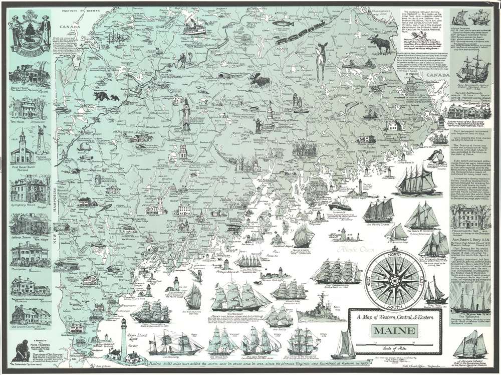

Title
A Map of Western, Central, and Eastern Maine.
1952 (undated) 21 x 27.75 in (53.34 x 70.485 cm) 1 : 950400
1952 (undated) 21 x 27.75 in (53.34 x 70.485 cm) 1 : 950400
Description
FOR THE ORIGINAL ANTIQUE MAP, WITH HISTORICAL ANALYSIS, CLICK HERE.
Digital Map Information
Geographicus maintains an archive of high-resolution rare map scans. We scan our maps at 300 DPI or higher, with newer images being 600 DPI, (either TIFF or JPEG, depending on when the scan was done) which is most cases in suitable for enlargement and printing.
Delivery
Once you purchase our digital scan service, you will receive a download link via email - usually within seconds. Digital orders are delivered as ZIP files, an industry standard file compression protocol that any computer should be able to unpack. Some of our files are very large, and can take some time to download. Most files are saved into your computer's 'Downloads' folder. All delivery is electronic. No physical product is shipped.
Credit and Scope of Use
You can use your digial image any way you want! Our digital images are unrestricted by copyright and can be used, modified, and published freely. The textual description that accompanies the original antique map is not included in the sale of digital images and remains protected by copyright. That said, we put significant care and effort into scanning and editing these maps, and we’d appreciate a credit when possible. Should you wish to credit us, please use the following credit line:
Courtesy of Geographicus Rare Antique Maps (https://www.geographicus.com).
How Large Can I Print?
In general, at 300 DPI, you should at least be able to double the size of the actual image, more so with our 600 DPI images. So, if the original was 10 x 12 inches, you can print at 20 x 24 inches, without quality loss. If your display requirements can accommodate some loss in image quality, you can make it even larger. That being said, no quality of scan will allow you to blow up at 10 x 12 inch map to wall size without significant quality loss. For more information, it is best consult a printer or reprographics specialist.
Refunds
If the high resolution image you ordered is unavailable, we will fully refund your purchase. Otherwise, digital images scans are a service, not a tangible product, and cannot be returned or refunded once the download link is used.
Cartographer
Ruth Rhoads Lepper Gardner (June 27, 1905 - April 16, 2011) was an American cartographer and artist known for her work along the coast of Maine. Born in Norwood, Massachusetts, Gardner attended Pembroke College of Brown University in Providence, Rhode Island, the Rhode Island School of Design, and the Museum School at the Museum of Fine Arts in Boston. She also received an art education from her artistic aunt, Annie L. Cox, as a young woman and had the opportunity to travel the world with her as her protégé. Gardner also lived in Greenwich Village in New York City as a young woman and remembered Wall Street financiers leaping to their deaths during the Great Depression. She served as an artist-in-residence at the Maine Sea Coast Mission in the 1940s, where she captured hundreds of scenes of life in Maine through pen-and-ink drawings while traveling aboard the Mission's ship Sunbeam III. During World War II, Gardner worked as a cartographer for the Navy, where she met her future husband, Cornelius Gardner. The couple married in 1947. It was during her time in the Navy that Gardner developed a love of cartography and, after the war, began producing pictorial maps of the Maine coast and the history of Maine. More by this mapmaker...
References
OCLC 181101087.