This item has been sold, but you can get on the Waitlist to be notified if another example becomes available, or purchase a digital scan.
1952 Lepper Pictorial Map of Southern Maine
WesternCentralEasternMaine-lepper-1952$150.00

Title
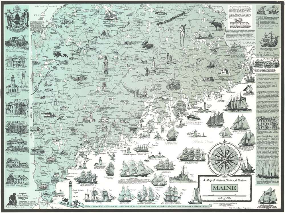
A Map of Western, Central, and Eastern Maine.
1952 (undated) 21 x 27.75 in (53.34 x 70.485 cm) 1 : 950400
1952 (undated) 21 x 27.75 in (53.34 x 70.485 cm) 1 : 950400
Description
This is a c. 1952 Ruth Rhoads Lepper Gardner pictorial map of southern Maine. The map depicts the region from the Maine - New Hampshire border and the Chaudière River in Canada to the Atlantic Ocean and from Quebec, Canada and Moosehead Lake, Maine to Isles of Shoals. Highly detailed, cities and towns throughout Maine are identified, including Augusta, Lewiston, Bangor, and Portland. Vignettes illustrated sites throughout the state, highlighting historic events and locations, as well as other points of interest, such as museums, historic houses, and the world's tallest wooden Indian. Numerous ships are drawn in profile, paying homage to Maine's long history as shipbuilders. Ship dating from as early as 1690 are present, with the most recent being a destroyer that was built in Bath in 1952. Per the map, the first six-mast ship ever built was constructed in Camden in 1900. Lighthouses all along the coast are also illustrated and labeled. A history of Maine is provided along the right border, while views of historic houses, a church, and an observatory are included along the left border.
Publication History and Census
This map was drawn and published by Ruth Rhoads Lepper c. 1952. Only one example is catalogued in the OCLC as being part of the collection at the University of Maine at Orono.Cartographer
Ruth Rhoads Lepper Gardner (June 27, 1905 - April 16, 2011) was an American cartographer and artist known for her work along the coast of Maine. Born in Norwood, Massachusetts, Gardner attended Pembroke College of Brown University in Providence, Rhode Island, the Rhode Island School of Design, and the Museum School at the Museum of Fine Arts in Boston. She also received an art education from her artistic aunt, Annie L. Cox, as a young woman and had the opportunity to travel the world with her as her protégé. Gardner also lived in Greenwich Village in New York City as a young woman and remembered Wall Street financiers leaping to their deaths during the Great Depression. She served as an artist-in-residence at the Maine Sea Coast Mission in the 1940s, where she captured hundreds of scenes of life in Maine through pen-and-ink drawings while traveling aboard the Mission's ship Sunbeam III. During World War II, Gardner worked as a cartographer for the Navy, where she met her future husband, Cornelius Gardner. The couple married in 1947. It was during her time in the Navy that Gardner developed a love of cartography and, after the war, began producing pictorial maps of the Maine coast and the history of Maine. More by this mapmaker...
Condition
Very good. Even overall toning. Top right corner reinstated. Blank on verso.
References
OCLC 181101087.