Digital Image: 1835 Las Cases (Lesage) and Renouard Map of the Western Hemisphere
WesternHemisphere-renouard-1835_d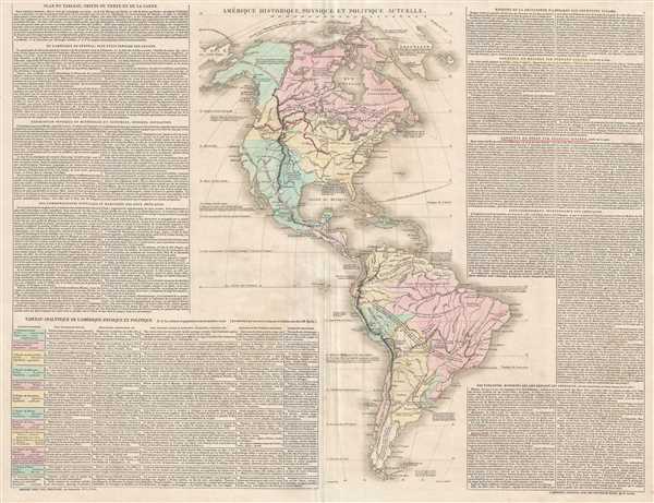

Title
Amérique Historique, Physique et Politique Actuelle.
1835 (undated) 19.75 x 26 in (50.165 x 66.04 cm) 1 : 30000000
1835 (undated) 19.75 x 26 in (50.165 x 66.04 cm) 1 : 30000000
Description
FOR THE ORIGINAL ANTIQUE MAP, WITH HISTORICAL ANALYSIS, CLICK HERE.
Digital Map Information
Geographicus maintains an archive of high-resolution rare map scans. We scan our maps at 300 DPI or higher, with newer images being 600 DPI, (either TIFF or JPEG, depending on when the scan was done) which is most cases in suitable for enlargement and printing.
Delivery
Once you purchase our digital scan service, you will receive a download link via email - usually within seconds. Digital orders are delivered as ZIP files, an industry standard file compression protocol that any computer should be able to unpack. Some of our files are very large, and can take some time to download. Most files are saved into your computer's 'Downloads' folder. All delivery is electronic. No physical product is shipped.
Credit and Scope of Use
You can use your digial image any way you want! Our digital images are unrestricted by copyright and can be used, modified, and published freely. The textual description that accompanies the original antique map is not included in the sale of digital images and remains protected by copyright. That said, we put significant care and effort into scanning and editing these maps, and we’d appreciate a credit when possible. Should you wish to credit us, please use the following credit line:
Courtesy of Geographicus Rare Antique Maps (https://www.geographicus.com).
How Large Can I Print?
In general, at 300 DPI, you should at least be able to double the size of the actual image, more so with our 600 DPI images. So, if the original was 10 x 12 inches, you can print at 20 x 24 inches, without quality loss. If your display requirements can accommodate some loss in image quality, you can make it even larger. That being said, no quality of scan will allow you to blow up at 10 x 12 inch map to wall size without significant quality loss. For more information, it is best consult a printer or reprographics specialist.
Refunds
If the high resolution image you ordered is unavailable, we will fully refund your purchase. Otherwise, digital images scans are a service, not a tangible product, and cannot be returned or refunded once the download link is used.
Cartographer S
Emmanuel-Augustin-Dieudonné-Joseph, comte de Las Cases (June 21, 1766 - May 15, 1842) was a French historian and atlas maker. Born at the family's castle near Revel in Languedoc, Las Cases was educated at military schools in Vendôme and Paris. He then entered the navy where he saw action during the years 1781-82. He was forced to flee France during the French Revolution, and spent several years in Germany and England. He took part in the Quiberon Expedition in 1795 (an invasion of France on the Quiberon peninsula by émigré ,counter-revolutionary troops in support of the Vendée Revolt) that was soundly defeated by the Republican army. Las Cases was one of the few to return to London alive. In 1801 he published the first edition of his Atlas Historique under the pseudonym A. Lesage. Upon his return to France after the Peace of Amiens in 1802, Las Cases published the first French edition of his atlas in 1803-1804 called the Atlas historique, généalogique, chronologique et géographique de A. Lesage. Las Casas returned to France during the Consulate and, with other royalists, rallied to the side of Napoleon Bonaparte. Las Cases would support Napoleon throughout his reign, and was eventually made a chamberlain and then a count of the empire. After the first abdication in 1814, Las Cases again fled to England, but returned to Napoleon's side during the Hundred Days. After the defeat at Waterloo, Las Cases was the one who suggested Napoleon throw himself at the mercy of the British Empire and later accompanied him to Saint Helena. It was on Saint Helena where Las Cases acted as Napoleon's secretary, taking detailed notes of their conversations. These notes were then published in book form following Napoleon's death as Le Mémorial de Sainte-Hélène, which is remembered as a less-than-neutral account of Napoleon's time on Saint Helena. More by this mapmaker...
Alexandre Moisy (1763 - c. 1827), also known as Claude Alexandre Moisy, was a French engraver. Born in Paris, Moisy was a prolific engraver who worked on numerous projects, several of which were books. Some of the texts that he contributed engravings to include Voyage picturesque de la Syrie, de la Phénicie de la Palestine, et de la Base Égypte by Louis Françpis Cassas and published in 1799 and Les ruined de Paestum by Claude Mathieu Delagardette published in 1798. Moisy also engraved all the plates for the book entitled Les Fontaines de Paris, Anciennes et Nouvelles, for which he drew all the engravings and also served as the editor. Learn More...
Paul Renouard (1803 - 1871) was a French printer and publisher. He was the third son of the famous Parisian bookseller Antoine-Augustin Renouard (1765 - 1853), and brother of publisher Jules Renouard (1798 - 1854). He was active in the book printing and publishing worked until 1849 when he retired and began a career in the foreign service in Asia. Learn More...
Source
Las Cases, E. Atlas historique, généalogique, chronologique, et géographique (Paris: Paul Renouard) 1827.
Originally published as the Geneaological, Chronological, Historical, and Geographical Atlas under the pseudonym A. Lesage by Emmanuel, Comte de Las Cases in 1801 during his exile from France caused by the French Revolution. Las Cases then published the first French edition, entitled Atlas historique, généalogique, chronologique, et géographique in 1803. Numerous subsequent editions were published in French, Russian, Italian, and German through approximately 1850.
References
OCLC 733693992.