This item has been sold, but you can get on the Waitlist to be notified if another example becomes available.
1940 Denoyer-Geppert Wall Map of Statehood in the Western U.S.
WesternStatehood-hart-1940$150.00

Title
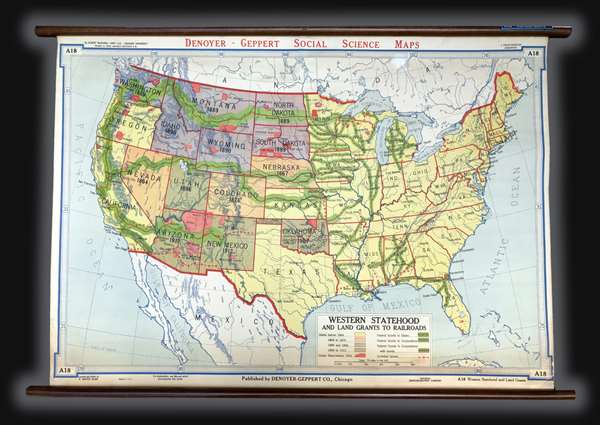
Western Statehood and Land Grants for Railroads.
1940 (undated) 30.5 x 43.5 in (77.47 x 110.49 cm) 1 : 4752000
1940 (undated) 30.5 x 43.5 in (77.47 x 110.49 cm) 1 : 4752000
Description
This is a c. 1940s Albert Bushnell Hart and Denoyer-Geppert Company wall map of the United States. The map depicts the continental United States from the Pacific Ocean to the Atlantic Ocean and from Canada to Mexico. As a means of illustrating the westward expansion of the United States, several different colors are used to differentiate between when different states achieved statehood. By employing these different colors, the piecemeal way the United States expanded from the Atlantic to the Pacific is easily distinguishable. For example, all the yellow states achieved statehood before 1864, which means that both California and Oregon, on the Pacific coast, became states long before the majority of the states in the Trans-Mississippi West. The Indian reservations that had been established by 1916 are depicted in red.
One of the major factors in the westward expansion of the United States was the railroad. Several different systems of grants were established to help foster the creation of the rail system, which are differentiated here. The Northern Pacific, Central Pacific, Union Pacific, and Southern Pacific lines are labeled and the different means by which they received the land grants is noted. Even forfeited grants are included. Regarding the general geography of the United States, the state capitals and other major cities are labeled, as well as rivers and the Great Lakes. A key is located along the bottom border.
This map was created by Albert Bushnell Hart with L. Philip Denoyer serving as geographer. The map was compiled and drawn by R. Baxter Blair and published by the Denoyer-Geppert Company of Chicago. It is number A18 in the Denoyer-Geppert Social Science map series. We have dated this map as c. 1940s due to the paper it is printed on. Several different editions of this map were printed, which allows for the possibility that this particular example could date from an earlier or later year.
CartographerS
The Denoyer-Geppert Company (1916 - 1984) was a Chicago-based publishing firm that dealt in maps, atlases, and spherical cartography (globes). For 68 years, the company played a critical role in the education of the world’s students. Founded in 1916 by Otto E. Geppert (the salesman) and L. Philip Denoyer (the cartographer/editor). Denier was born in Milwaukee in 1875 and was a high school principal by the age of 32. He was also completing graduate work at the University of Chicago at the same time. He was appointed the first Professor of Geology and Geography at the State Teacher’s College - La Crosse (University of Wisconsin) in 1909. Legend has it that Denoyer met Geppert while teaching one of his classes, when the latter came up from Chicago to sit in on one. Geppert was working as a salesman for A.J. Nystrom and Company, which today self-identifies as ‘the United States’ older publisher of wall maps and globes for classroom use.’ Geppert was there to sell Denoyer on joining the team at Nostrum, believing that his expertise could benefit the company. Three years later they founded the Denoyer-Geppert Company, and within six years had moved from a 500 square foot space into the 50,000 square foot Swedish-American Telephone Building. By 1922, their catalogue consisted of ‘1,200 maps, charts, globes, and associate aids in teaching geography and history and 800 brilliantly illuminated biological charts and anatomical models.’ In 1967, Denoyer-Geppert was contracted by NASA to build the first official and accurate ‘lunar globe’, based on information gathered by Apollo 10 astronauts. The company made 200 of these globes, the first of which was presented by the astronauts of Apollo 10 to President Nixon. Rand McNally, one of their major competitors, bought out their inventory of maps and globes in 1984. Denoyer-Geppert left the Swedish-American Telephone Building and reinvented the company as the Denoyer-Geppert Science Company, which specializes in anatomical models for classrooms. The Swedish-American Telephone Company has been named a historic landmark and was remodeled into loft apartments. More by this mapmaker...
Albert Bushnell Hart (July 1, 1854 - July 16, 1943), a member of the Harvard University faculty for 43 years, was an American historian, writer, and editor. Hart was one of the first generation of professionally trained historians in the United States and a prolific author. He graduated from Harvard in 1880 and went on to study in Paris, Berlin, and Freiburg. He received his doctorate at Freiburg in 1883. He returned to Harvard that year as the instructor of the American history course offered at the time and retired in 1926. Learn More...
Condition
Very good. Backed on linen. Attached to original rollers. Measurment is for the map itself. Since the map is attached to rods, they add an another 2 inches in height and 3.5 inches in width.
References
OCLC 317562267.