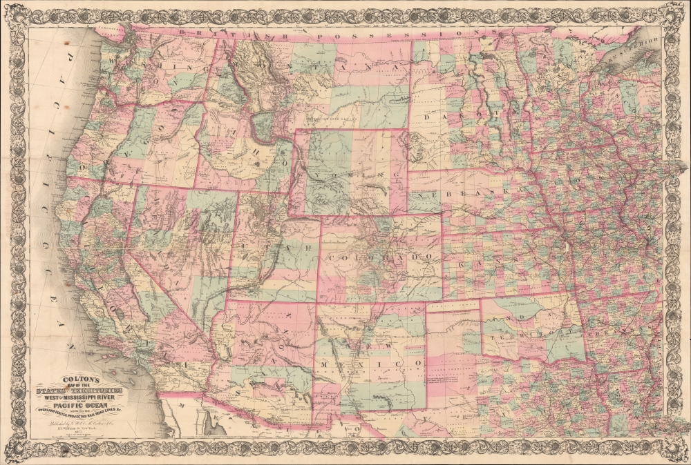
1877 Colton Map of the United States West of the Mississippi
WesternStates-colton-1877$1,000.00


Title
Colton's Map of the States and Territories West of the Mississippi River to the Pacific Ocean showing the Overland Routes, Projected Rail Road Lines etc.
1877 (dated) 29.5 x 43.5 in (74.93 x 110.49 cm) 1 : 2900000
1877 (dated) 29.5 x 43.5 in (74.93 x 110.49 cm) 1 : 2900000
Description
An impressive 1877 Colton large-scale map of the United States west of the Mississippi River. The map was issued during a period of mass westward migration, opportunity, and development. The Central Pacific Railroad was completed in 1869, and when this map was issued, both the Northern Pacific and the Southern Pacific, as well as numerous ancillary railroads, were well underway. The California Gold Rush was over, but massive gold and silver discoveries followed in Colorado, Nevada, Oregon, and Washington, driving wealth into the economy and spurring high-paced development and urbanization. New states and territories appeared annually: Colorado became a state one year before this map was issued.
A Closer Look
Coverage embraces the western United States from the Pacific to the Mississippi River - with extensions breaking the eastern border to include Chicago and New Orleans. The map focuses on political divisions and transportation, with overland routes, rivers, and, most significantly, existing and proposed railroads prominent. Numerous forts appear in New Mexico - evidence of continuous warfare with the Apache.Publication History and Census
This map was first issued in 1864, although in a smaller format with the title on the right side. That map was likely published in response to the rise of the Bancroft firm in San Francisco and their publications of similar maps. The map was expanded to roughly twice the 1864 size in 1872 when an elaborate decorative border was added, and the title moved to the lower left. The map was regularly and systematically updated as new roads, railroads, and political divisions emerged. Consequently, multiple editions appeared well into the 1880s. Well represented institutionally but scarce to the market.Cartographer
Joseph Hutchins Colton (July 5, 1800 - July 29, 1893), often publishing as J. H. Colton, was an important American map and atlas publisher active from 1833 to 1897. Colton's firm arose from humble beginnings when he moved to New York in 1831 and befriended the established engraver, Samuel Stiles. He worked under Stiles as the 'Co.' in Stiles and Co. from 1833 to 1836. Colton quickly recognized an emerging market in railroad maps and immigrant guides. Not a cartographer or engraver himself, Colton's initial business practice mostly involved purchasing the copyrights of other cartographers, most notably David H. Burr, and reissuing them with updated engraving and border work. His first maps, produced in 1833, were based on earlier Burr maps and depicted New York State and New York City. Between 1833 and 1855, Colton proceeded to publish a large corpus of guidebooks and railroad maps, which proved popular. In the early 1850s, Colton brought his two sons, George Woolworth Colton (1827 - 1901) and Charles B. Colton (1832 - 1916), into the map business. G. W. Colton, trained as a cartographer and engraver, was particularly inspired by the idea of creating a large and detailed world atlas to compete with established European firms for the U.S. market. In 1855, G.W. Colton issued volume one of the impressive two-volume Colton's Atlas of the World. Volume two followed a year later. Possibly because of the expense of purchasing a two-volume atlas set, the sales of the Atlas of the World did not meet Colton's expectations, and so, in 1856, the firm also issued the atlas as a single volume. The maps contained in this superb work were all original engravings, and most bear an 1855 copyright. All of the maps were surrounded by an attractive spiral motif border that would become a hallmark of Colton's atlas maps well into the 1880s. In 1857, the slightly smaller Colton's General Atlas replaced the Atlas of the World. Most early editions of the General Atlas published from 1857 to 1859 do not have the trademark Colton spiral border, which was removed to allow the maps to fit into a smaller format volume. Their customers must have missed the border because it was reinstated in 1860 and remained in all subsequent publications of the atlas. There were also darker times ahead; in 1858, Colton was commissioned at a sum of 25,000 USD by the government of Bolivia to produce and deliver 10,000 copies of a large format map of that country. Although Colton completed the contract in good faith, delivering the maps at his own expense, he was never paid by Bolivia, which was at the time in the midst of a series of national revolutions. Colton would spend the remainder of his days fighting with the Bolivian and Peruvian governments over this payment, and in the end, after a congressional intervention, he received as much as 100,000 USD in compensation. Nonetheless, at the time, it was a disastrous blow. J. H. Colton and Company is listed as one of New York's failed companies in the postal record of 1859. This led Colton into the arms of Alvin Jewett Johnson and Ross C. Browning. The 1859 edition of Colton's General Atlas lists Johnson and Browning as the 'Successor's to J. H. Colton' suggesting an outright buyout, but given that both companies continued to publish separately, the reality is likely more complex. Whatever the case may have been, this arrangement gave Johnson and Browning access to many of Colton's map plates and gave birth to Johnson's New Illustrated (Steel Plate) Family Atlas. The Johnson's Atlas was published parallel to Colton's atlases well into the 1880s. The Colton firm itself subsequently published several other atlases including an Atlas of America, the Illustrated Cabinet Atlas, the Octavo Atlas of the Union, and Colton's Quarto Atlas of the World. They also published a large corpus of wall maps, pocket maps, and guides. The last known publications of the Colton firm date to 1897 and include a map and a view, both issued in association with the Merchant's Association of New York. Alice M. Colton married August R. Ohman (May 3, 1859 - April 22, 1934) on January 5, 1897. In 1898, Ohman joined the Colton firm, which continued to publish as Colton, Ohman & Co. until 1901. More by this mapmaker...
Condition
Good. Stabilized on archival tissue. Multiple repaired and stabilized splits along original fold lines. Slight loss at some fold intersections.
References
OCLC 1113869417. Wheat, C. I., Mapping of the Transmississippi West, 1540 – 1861, #1099.