Digital Image: 1888 Leavitt Pictorial Map of the White Mountains
WhiteMountains-leavitt-1888-2_d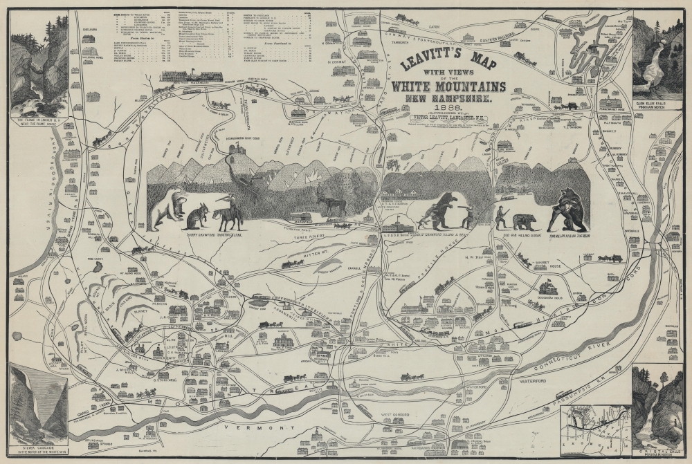


Title
Leavitt's Map with Views of the White Mountains, New Hampshire.
1888 (dated) 21 x 31 in (53.34 x 78.74 cm)
1888 (dated) 21 x 31 in (53.34 x 78.74 cm)
Description
FOR THE ORIGINAL ANTIQUE MAP, WITH HISTORICAL ANALYSIS, CLICK HERE.
Digital Map Information
Geographicus maintains an archive of high-resolution rare map scans. We scan our maps at 300 DPI or higher, with newer images being 600 DPI, (either TIFF or JPEG, depending on when the scan was done) which is most cases in suitable for enlargement and printing.
Delivery
Once you purchase our digital scan service, you will receive a download link via email - usually within seconds. Digital orders are delivered as ZIP files, an industry standard file compression protocol that any computer should be able to unpack. Some of our files are very large, and can take some time to download. Most files are saved into your computer's 'Downloads' folder. All delivery is electronic. No physical product is shipped.
Credit and Scope of Use
You can use your digial image any way you want! Our digital images are unrestricted by copyright and can be used, modified, and published freely. The textual description that accompanies the original antique map is not included in the sale of digital images and remains protected by copyright. That said, we put significant care and effort into scanning and editing these maps, and we’d appreciate a credit when possible. Should you wish to credit us, please use the following credit line:
Courtesy of Geographicus Rare Antique Maps (https://www.geographicus.com).
How Large Can I Print?
In general, at 300 DPI, you should at least be able to double the size of the actual image, more so with our 600 DPI images. So, if the original was 10 x 12 inches, you can print at 20 x 24 inches, without quality loss. If your display requirements can accommodate some loss in image quality, you can make it even larger. That being said, no quality of scan will allow you to blow up at 10 x 12 inch map to wall size without significant quality loss. For more information, it is best consult a printer or reprographics specialist.
Refunds
If the high resolution image you ordered is unavailable, we will fully refund your purchase. Otherwise, digital images scans are a service, not a tangible product, and cannot be returned or refunded once the download link is used.
Cartographer
Franklin Leavitt (1824 - 1898) was an American 'jack-of-all-trades' who held jobs as a guide, hotelier, and contractor, and also aspired to be an artist and poet. Born in or near Lancaster, New Hampshire, Leavitt worked in the Notch House, an inn near Crawford Notch, as a young man, and also helped build trails and the Carriage Road (now the Auto Road). With the advent of a rail connection into the White Mountains, Leavitt apparently came to the conclusion that tourists would soon follow, and would create a market for a souvenir tourist map. He drew one and took it to one of the best printers in Boston to be printed. Leavitt then sold the maps himself in hotels and train stations throughout the region. By the time of his death, Leavitt had created six different pictorial tourist maps of the White Mountains. More by this mapmaker...