1943 Chapin Map of Eastern Europe during World War II
WinterProjectionPoland-chapin-1943$400.00

Title
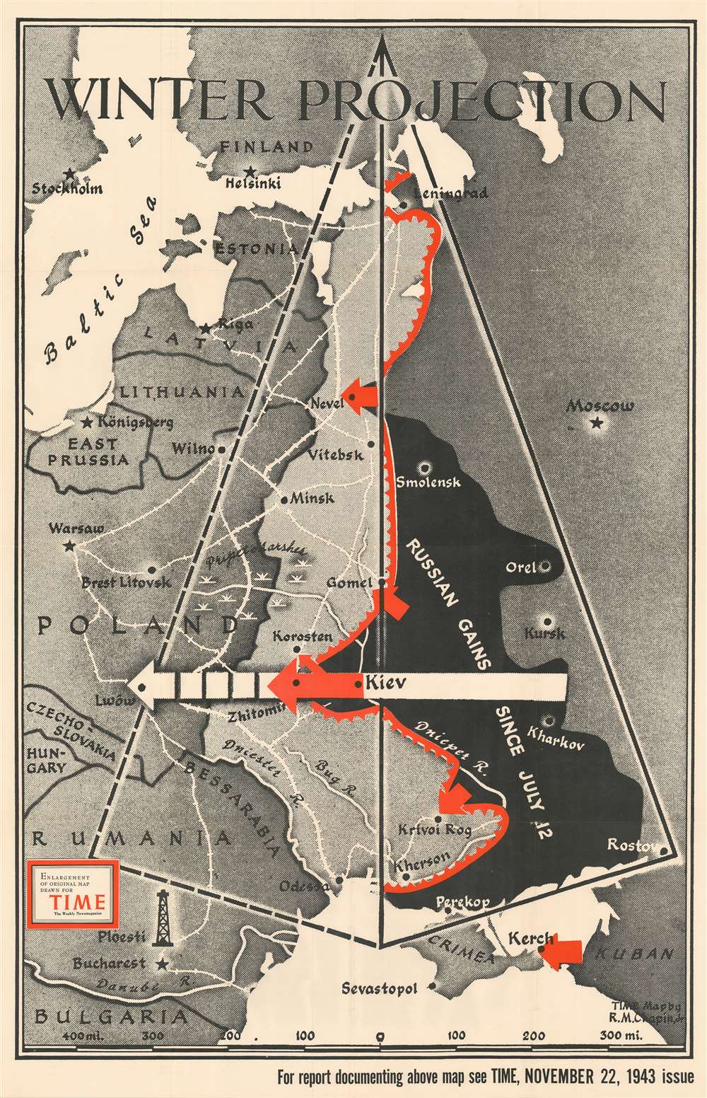
Winter Projection.
1943 (dated) 44 x 28.5 in (111.76 x 72.39 cm) 1 : 2000000
1943 (dated) 44 x 28.5 in (111.76 x 72.39 cm) 1 : 2000000
Description
This separately-issued large-format 1943 Robert M. Chapin map of Eastern Europe during World War II celebrates Russian victories on the Eastern Front in the late summer and fall of that year. When this map was published, the Soviets were on the cusp of pushing the Wehrmacht out of Russia's pre-1939 borders. Territory shaded black highlights the ground regained by the Russians, while red arrows bring the viewer's focus to areas of renewed offensives. Chapin employs geometry to 'project' just how far the Red Army could push the Germans in the coming months as the hearty Russian army choose to ignore the onset of winter and keep attacking the retreating Germans.
Publication History and Census
This map was initially drawn by Robert M. Chapin, Jr. for publication in the November 22, 1943 issue of TIME Magazine. The present example is an enlargement of that map and was published separately. It also bears a collection stamp from the Ashtabula Public Library in Ohio on verso. We have contacted the library and confirmed that it was legally deaccessioned. Two examples are cataloged in OCLC and are part of the institutional collections at Franklin and Marshall College and Wichita State University.Cartographer
Robert M. Chapin Jr. (fl. 1933 - 1970) was a prominent architect, cartographer and illustrator active during World War II and the Cold War. Chapin graduated from the University of Pennsylvania in 1933 with a degree in architecture. Since this was the height of the Great Depression, and architects in low demand, he instead took work as a staff cartographer at Newsweek. Catching the attention of Manfred Gottfried of Time, Chapin was offered an accepted a position at the head of Time's cartography department. He remained with Time for some 33 years, from 1937 to 1970, often drawn 2 - 3 new thematic maps weekly. With an architect's gift visualizing information, Chapin became a skilled informational cartographer, heading the cartography department at Time Magazine. Chapin, like Fortune Magazine chief cartographer, Richard Edes Harrison, Chapin was at the forefront of infographic propaganda cartography, a genre that matured during the World War II Era and remains popular today. Working for Time Magazine, Chapin developed a signature style for his long run of 'War Maps.' Chapin was known for his maverick airbrush technique which lead to strong color splashes and intense shading. He also incorporated celluloid stencils to illustrate bomb explosions, flags, sinking ships, and more - generating a instantly recognizable standardized style. Chapin's Time war maps were further distinctive for their use of strong bold reds as a universal symbol of hostility. Chapin graduated from the University of Pennsylvania in 1933 with a degree in architecture. Since this was the height of the Great Depression, an d architects in low demand, he instead took work as a staff cartographer at Newsweek. Catching the attention of Manfred Gottfried of Time, Chapin was offered an accepted a position at the head of Time's cartography department. He remained with Time for some 33 years, from 1937 to 1970, often drawn 2 - 3 new thematic maps weekly. Chapin live in Sharon Connecticut. More by this mapmaker...
Condition
Very good. Light wear along original fold lines. Bears collection stamp from the Ashtabula Public Library in Ohio on verso. We have contacted the library and confirmed that it was legally deaccessioned.
References
OCLC 47735423.