1849 Greenleaf Map of Wisconsin and Iowa
WisconsinIowa-greenleaf-1849$1,400.00

Title
Wisconsin and Iowa.
1849 (undated) 11 x 14 in (27.94 x 35.56 cm) 1 : 4000000
1849 (undated) 11 x 14 in (27.94 x 35.56 cm) 1 : 4000000
Description
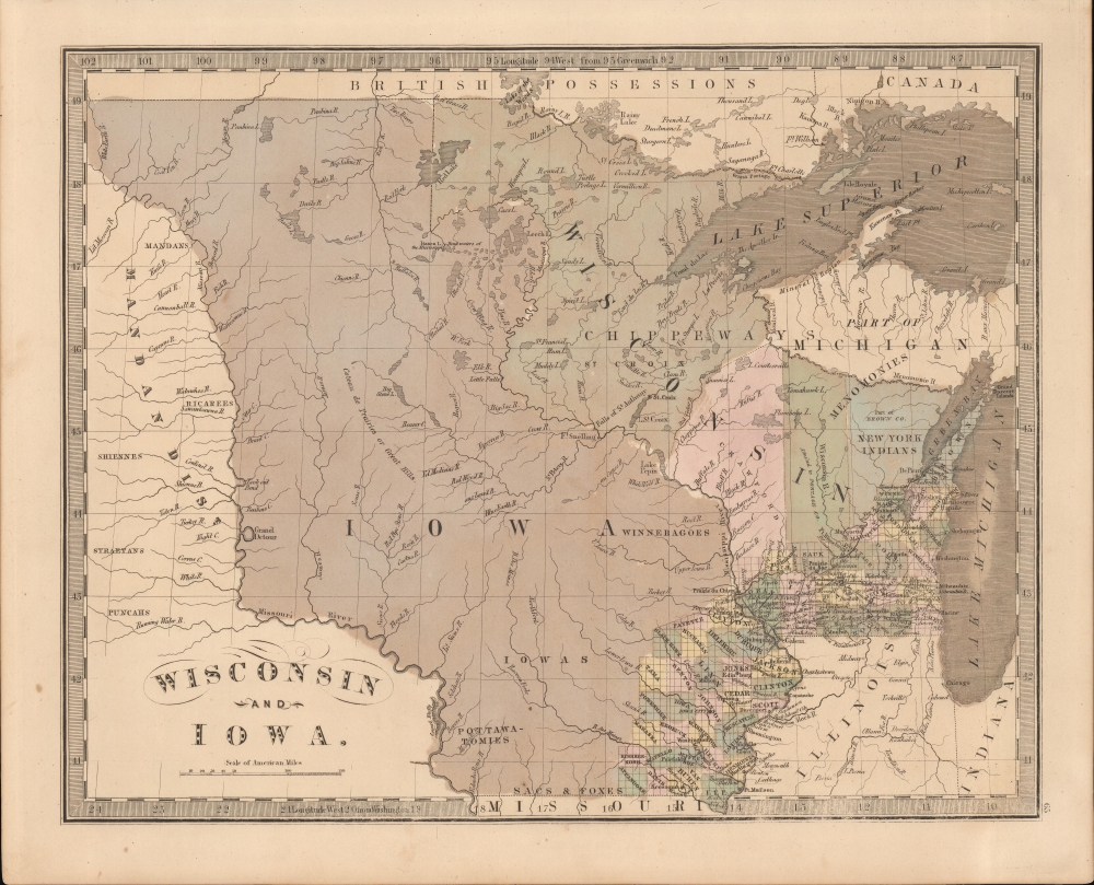
This is the 1849 J. Greenleaf map of Iowa Territory (Minnesota) and Wisconsin. The map reveals early border disagreements relating to the western limits of Iowa and Wisconsin and a pre-Minnesota Territory (March 3, 1849) configuration.
Borders in Conflict
Although Iowa was incorporated as a state in 1846 and Wisconsin in 1848, this map depicts both in their territorial configuration and reflects the prior four years of congressional debate as to where the borders should fall. When Iowa was carved out of Iowa Territory, the northern border was set at 43º 30′ N, leaving the northern part of Iowa Territory, a vast tract extending from Lake Superior to the Missouri River, to become the Minnesota Territory. Wisconsin at the time was lobbying to extend its own western borders in accordance with the 1787 Northwest Ordnance as far as the source of the Mississippi (Lake Itasca), and it is here so settled at 96º W, well west of the current boundaries.A Rare Revision
This map was a new addition to the Greenleaf atlas, appearing for the first time in 1842 and here revised in a third edition. Major revisions include the removal of the fraudulent Carver Tract in Wisconsin and the introduction of Crawford and St. Croix Counties. The map notes the 'New York Indians' near Green Bay, a reference to relocated Oneida, Stockbridge, Munsee, and Brothertown tribes. Of note is that the U.S.-Canada border has moved south to follow Grand Portage to Rainy Lake. The Lake of the Woods correctly appears as the northern boundary of the United States according to the 1846 Oregon Treaty. There has been considerable revision in the Iowa territory, including the naming of Pottawatomie and Winnebago lands. Council Bluffs appear for the first time just west of the Missouri River.Publication History and Census
The present example is from the 1849 edition of the Greenleaf atlas, the last and final, which was extensively revised over the 1848 issue. The map first appeared in 1842, again in 1848, and, as here in 1849, making this the third state. We note an example in the David Rumsey Map Collection, which has been populated digitally throughout OCLC, making a comprehensive survey of existing physical examples nearly impossible. Nonetheless, the 1849 edition of the atlas is rare, and Rumsey correctly noted that it is not in Karpinski. However, we do note an example in Phillips.Cartographer
Jeremiah Greenleaf (1791 - 1864) is a little known but highly admired American cartographer of the early 19th century. He published from roughly 1830 to 1850. His most important work is A New Universal Atlas; Comprising of all the Principal Empires, Kingdoms, and States Throughout the World and Forming a distinct Atlas of the United States, published in several editions in the 1840s. Many of his maps are reformatted versions of his contemporary David Burr's much admired cartographic works. Greenleaf's maps are extremely rare and admired for their stunningly vivid pastel color washes. More by this mapmaker...
Source
Greenleaf, J., New Universal Atlas, (Brattleboro, Vermont: Greenleaf) 1849.
Condition
Very good.
References
Rumsey 15176.069.