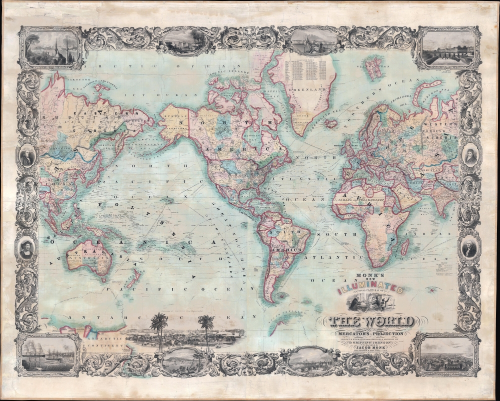
1860 Monk / Johnson Wall Map of the World
World-johnsonmonk-1860$4,750.00


Title
Monk's New Illuminated Steel Plate Map of The World Embracing all the Latest Discoveries and Exploration on Mercator's Projection.
1860 (dated) 52 x 64.75 in (132.08 x 164.465 cm) 1 : 29860000
1860 (dated) 52 x 64.75 in (132.08 x 164.465 cm) 1 : 29860000
Description
This is a magnificent 1860 wall map of the world issued by Jacob Monk and David Griffing Johnson. The map is subtitled 'illuminated' and is a lavish production, rich with detail and graphic content.
In the United States, note the ephemeral territorial configuration in the Transmississippi, with outsized Utah, New Mexico, Nebraska, Washington, and Oregon territories. The presumptive Territory of Arizona appears in southern New Mexico - a request was submitted to Congress to create this territory just before this map was made, but it was denied. Shortly thereafter, at the outbreak of the American Civil War, the Confederacy recognized it as a Confederate State. The tracks of significant voyages are noted throughout. In Africa, much of central Africa remains 'unexplored.' Some of the great lakes of the Rift Valley are beginning to take form, with ephemeral Lakes Victoria (Ukerewe) and Tanganyika (Uyiyi), based upon the 1858 voyages of Speke, recognizable.
A Closer Look
It is centered on the Americas and extends west to Burma and east to the Bay of Bengal. The whole is surrounded by an elaborate decorative border showcasing Johnson's masterful engraving, featuring illustrations of Constantinople, Bombay, St. Petersburg, Paris, New York, Quebec, London, and New Orleans. Decorating the panels are portraits of Benjamin Franklin, Columbus, Robert Fulton, and George Washington. At the bottom, just to the left of the center, is a large vignette view of Havana.In the United States, note the ephemeral territorial configuration in the Transmississippi, with outsized Utah, New Mexico, Nebraska, Washington, and Oregon territories. The presumptive Territory of Arizona appears in southern New Mexico - a request was submitted to Congress to create this territory just before this map was made, but it was denied. Shortly thereafter, at the outbreak of the American Civil War, the Confederacy recognized it as a Confederate State. The tracks of significant voyages are noted throughout. In Africa, much of central Africa remains 'unexplored.' Some of the great lakes of the Rift Valley are beginning to take form, with ephemeral Lakes Victoria (Ukerewe) and Tanganyika (Uyiyi), based upon the 1858 voyages of Speke, recognizable.
Curious Pitcairn's Island Annotation
In the South Pacific, there is a curious note reading, 'Descendants of mutineers of ship Bounty removed from here from Pitcairns I. in 1856.' This refers to Norfolk Island, New Zealand, and mainland Australia, where, as a result of overcrowding on Pitcairn's Island, in 1856, all 194 Pitkerners immigrated to Norfolk Island. Later, in 1858, some 16 of these returned to Pitcairn, followed by a further 4 families in 1864.Publication History and Census
This map was engraved by David Griffing Johnson and published in collaboration with Jacob Monk. Some have pointed out its resemblance to D. G. Johnson's 1847 world map, but this is an entirely separate publication, with no relation to the earlier work other than its author. This is the only collaboration we are aware of between D. G. Johnson and Monk. It is also Monk's only world map. The map is copyrighted to D. G. Johnson in 1859, but there appears to have been but one edition, 1860. Rare. We note no examples in the OCLC or in any institutional collections.CartographerS
Jacob Monk (August 25, 1805 - October 8, 1893) was a Baltimore and Philadelphia based American publisher of wall, pocket, and case format maps active in the mid-19th century. Monk was born in Stoughton, Massachusetts. It is not clear when he moved to Philadelphia, but he was active there from about 1850, when he began a lucrative publishing career, to 1857, or so. By the standards of American map publishers, Monk was exceedingly successful due to his strategy of employing a national network of door-to-door salesmen to promote and sell his wall map. Monk maps, thus, are in general more widely distributed than those of his competitors. He married New Yorker Charlotte M. French (Monk; 1823 - 1903) around 1851. He is also the founder, in 1856, of the Mount Vernon Cemetery. Sometime in the 1860s, Monk acquired some 44 acres of land on the Schuylkill River, just outside of Philadelphia, setting himself up as a gentleman farmer. More by this mapmaker...
David Griffing Johnson (1808 - April 9, 1863), aka 'Griffin', is a mysterious but significant American engraver and mapmaker active in Portland, Maine, New Orleans, and New York City in the decades preceding the American Civil War (1861 - 1865). Our knowledge of him is scant. He was likely born in Connecticut. We believe him one and the same with David G. Johnson, a map engraver, who first appears in Portland, Maine in 1824, where he had an office at No. 4, Market Square in Gilbert’s Block. He was not a native to that city, instead arriving in 1824 with the intent to establish himself as the city's premier engraver. This seems not to have worked out, but he did produce a few maps, portraits, nautical charts, and novelties. He left Portland in 1830, eventually settling in New York, where we can place him in 1831. In New York he promoted himself as a portrait painter and engraver from 1831 to 1835. He appears to have had little success during this period, but did engrave the plates for the 1833 A Treatise on Topographical Anatomy. Shortly thereafter, he relocated to New Orleans. He was in New Orleans from at least 1838 to 1843, where he set up an engraving and daguerreotype studio. While there, he engraved E. H. Springbett and L. I. Pilié's 1839 Topographical Map of the City and Environs of New Orleans, of which we can frustratingly find no surviving examples but several references. We note correspondence in 1840 between Johnson and Samuel F. B. Morse (inventor of the telegraph and daguerreotype pioneer) asking for advice on daguerreotyping, suggesting that Johnson had difficulty with the process. He returned to New York in 1843, remaining until about 1847, when he issued a map with J. H. Colton. At some point, likely in 1848, D. Griffing Johnson headed west. His 1853 world map and his 1857 North America map both feature a large view of Sutter's Mill with the note, 'Drawn on the spot by D. G. Johnson in 1849'. It is thus believed he was at Sutter’s Mill when gold was discovered or shortly thereafter. There is record of a D. G. Johnson arriving in New York in 1849 on a ship from Jamaica - possibly a transit point having sailed around South America? He was in New York throughout the 1850s to about 1862 or 1863, producing several maps, including a large world wall map in 1853, a North America map in 1853 with 'Thayer, Bridgman and Fanning', and an 1854 North America map with A. J. Johnson, an 1860 world map with Jacob Monk, and an 1862 map of Maine with Henry Francis Walling and Jacob Chace Jr. In 1855 he had an office at 7 Nassau Street, New York. In 1859 he successfully defended himself in New York courts on charges of copyright violation by fellow mapmaker Robert Persall Smith. Regarding D. G. Johnson’s disappearance sometime after 1863, we can only speculate. If our reasoning stands, when was active in Maine in 1824 he would have been at least in his early 20s. Thus by 1863, he would have been in his late 60s, so it is likely he died, but records have been elusive. References: Groce, G.C,. and Wallace, D. H., The New-York Historical Society's Dictionary of Artists in America, 1864 - 1860, p. 353. Smith, M.G., and Tucker, M. L., Photography in New Orleans: The Early Year, 1840 - 1865, p 21-22. Palmquist, P. and Kailbourn, T. R., Pioneer Photographers from Mississippi to the Continental Divide, p. 357. Shettleworth, Earle G., 'Portland, Maine, Engravers of the 1820s', part II, 105 - 109, in Old-Time New England, Volume 61, Number 224 (Spring, 1971). Fales, Marthaq Gandy, 'An Unrecorded Portland Engraver', pages 77-79 in Old-Time New England, Volume 57, Number 207 (Winter, 1967). Learn More...
Condition
Very good. Full professional restoration. Some toning remains.