Digital Image: 1655 Scolari carte-à-figures Double-Hemisphere World
World-scolari-1655_d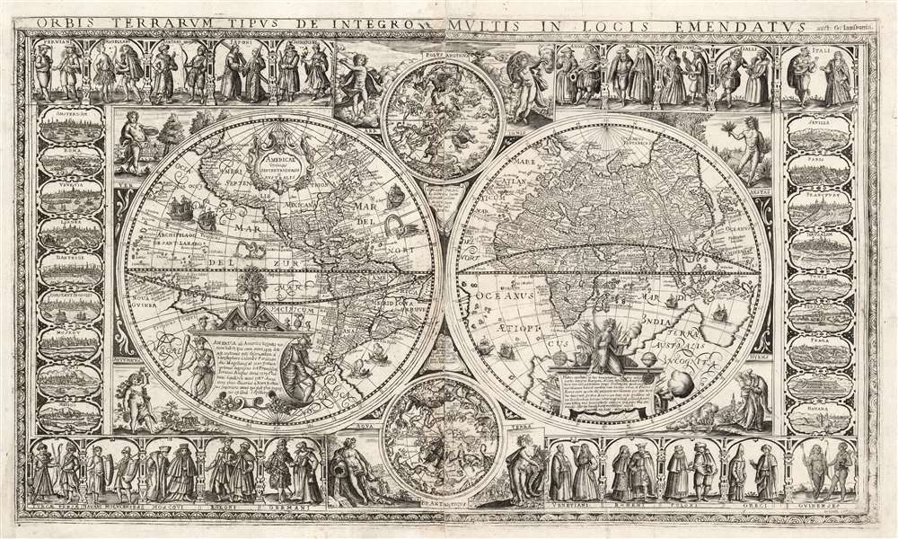

Title
Orbis Terrarum Tipus de Integro Multis in Locis Emendatus.
1655 (dated) 17.25 x 29.5 in (43.815 x 74.93 cm)
1655 (dated) 17.25 x 29.5 in (43.815 x 74.93 cm)
Description
FOR THE ORIGINAL ANTIQUE MAP, WITH HISTORICAL ANALYSIS, CLICK HERE.
Digital Map Information
Geographicus maintains an archive of high-resolution rare map scans. We scan our maps at 300 DPI or higher, with newer images being 600 DPI, (either TIFF or JPEG, depending on when the scan was done) which is most cases in suitable for enlargement and printing.
Delivery
Once you purchase our digital scan service, you will receive a download link via email - usually within seconds. Digital orders are delivered as ZIP files, an industry standard file compression protocol that any computer should be able to unpack. Some of our files are very large, and can take some time to download. Most files are saved into your computer's 'Downloads' folder. All delivery is electronic. No physical product is shipped.
Credit and Scope of Use
You can use your digial image any way you want! Our digital images are unrestricted by copyright and can be used, modified, and published freely. The textual description that accompanies the original antique map is not included in the sale of digital images and remains protected by copyright. That said, we put significant care and effort into scanning and editing these maps, and we’d appreciate a credit when possible. Should you wish to credit us, please use the following credit line:
Courtesy of Geographicus Rare Antique Maps (https://www.geographicus.com).
How Large Can I Print?
In general, at 300 DPI, you should at least be able to double the size of the actual image, more so with our 600 DPI images. So, if the original was 10 x 12 inches, you can print at 20 x 24 inches, without quality loss. If your display requirements can accommodate some loss in image quality, you can make it even larger. That being said, no quality of scan will allow you to blow up at 10 x 12 inch map to wall size without significant quality loss. For more information, it is best consult a printer or reprographics specialist.
Refunds
If the high resolution image you ordered is unavailable, we will fully refund your purchase. Otherwise, digital images scans are a service, not a tangible product, and cannot be returned or refunded once the download link is used.
Cartographer S
Stefano Mozzi Scolari (c. 1612 - 1691) was a Venetian engraver and printer active between 1644 and 1687. He was known primarily as an illustrator and would be among the first engravers to devote his activity entirely to illustrated editions. His work included pieces entirely drawn and engraved by himself, images produced in collaboration with other artists and editors, and the reproduction of already published copperplates. This latter area appears to have been the reproduction of maps by other authors - for example his 1657 edition of Greuter's 1630 map of Italy - including the production of maps incorporating elements of various authors in a single work. He is most associated with his work from the vicinity of the Venetian parish church of San Zulian, where he also probably had lived since 1642, but Stefano Bifolco has asserted that he was also connected to the printers' shop at Santa Fosca. He was a member of the Venetian painters' guild between 1660 and 1683; his wills reflect his status as a well-off craftsman and owner of a printer shop. More by this mapmaker...
Nicolaes van Geelkercken (ca. 1585 - 1656) was a Dutch surveyor, cartographer and publisher active in the early 17th century. He is thought to have begun his work as a cartographer, engraver, and colorist in the shop of Jodocus Hondius. Starting in 1610, he began producing maps to illustrate current conflicts of interest. In order to ensure that his news maps were up to date and accurate, Geelkercken was known to accompany the Dutch army on campaign. He was succeeded in his trade by his sons Isaac van Geelkercken, Jacob van Geelkercken and Arnold van Geelkercken. Learn More...
Jan Jansson or Johannes Janssonius (1588 - 1664) was born in Arnhem, Holland. He was the son of a printer and bookseller and in 1612 married into the cartographically prominent Hondius family. Following his marriage he moved to Amsterdam where he worked as a book publisher. It was not until 1616 that Jansson produced his first maps, most of which were heavily influenced by Blaeu. In the mid 1630s Jansson partnered with his brother-in-law, Henricus Hondius, to produce his important work, the eleven volume Atlas Major. About this time, Jansson's name also begins to appear on Hondius reissues of notable Mercator/Hondius atlases. Jansson's last major work was his issue of the 1646 full edition of Jansson's English Country Maps. Following Jansson's death in 1664 the company was taken over by Jansson's brother-in-law Johannes Waesberger. Waesberger adopted the name of Jansonius and published a new Atlas Contractus in two volumes with Jansson's other son-in-law Elizée Weyerstraet with the imprint 'Joannis Janssonii haeredes' in 1666. These maps also refer to the firm of Janssonius-Waesbergius. The name of Moses Pitt, an English map publisher, was added to the Janssonius-Waesbergius imprint for maps printed in England for use in Pitt's English Atlas. Learn More...
Claes Jansz Visscher (1587 - 1652) established the Visscher family publishing firm, which were prominent Dutch map publishers for nearly a century. The Visscher cartographic story beings with Claes Jansz Visscher who established the firm in Amsterdam near the offices of Pieter van den Keer and Jadocus Hondius. Many hypothesize that Visscher may have been one of Hondius's pupils and, under examination, this seems logical. The first Visscher maps appear around 1620 and include numerous individual maps as well as an atlas compiled of maps by various cartographers including Visscher himself. Upon the death of Claes, the firm fell into the hands of his son Nicholas Visscher I (1618 - 1679), who in 1677 received a privilege to publish from the States of Holland and West Friesland. The firm would in turn be passed on to his son, Nicholas Visscher II (1649 - 1702). Visscher II applied for his own privilege, receiving it in 1682. Most of the maps bearing the Visscher imprint were produced by these two men. Many Visscher maps also bear the imprint Piscator (a Latinized version of Visscher) and often feature the image of an elderly fisherman - an allusion to the family name. Upon the death of Nicholas Visscher II, the business was carried on by the widowed Elizabeth Verseyl Visscher (16?? - 1726). After her death, the firm and all of its plates was liquidated to Peter Schenk. Learn More...
References
cf.OCLC 50784513. Compare with Shirley, Rodney W., The Mapping of the World: Early Printed World Maps 1472-1700, #295, #333 and #346. cf. Klaus Stopp, ‘Drei Karten von Francesco Sabatini', Mappae Antiquae Liber Amicorum.